Property Record
3610 N Main St, Paris, TX 75460
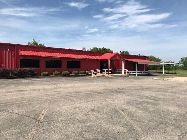


Property Detail
3610 N Main St
Paris, TX
TYLER'S PIZZERIA ADDITION, LOT 1, 3180 N MAIN, ACRES 2.79 3180 N MAIN
108707
LAMAR
Commercialnec
Texas
B and X Area of moderate flood hazard, usually the area between the limits of the 100-year and 500-year floods.
1
2024
2.79 AC
2025
Texas East Area
000500
Other Market Areas
9,261 SF
NEARBY LISTINGS FOR SALE OR LEASE
DEMOGRAPHICS near 3610 N Main St
1 mile
3 mile
5 mile
2025 Total Population
803
11,695
29,409
2030 Population
833
12,145
30,189
Pop Growth 2025-2030
+ 3.74%
+ 3.85%
+ 2.65%
Average Age
39
40
41
2025 Total Households
308
4,902
12,096
HH Growth 2025-2030
+ 3.25%
+ 3.79%
+ 2.64%
Median Household Inc
$21,643
$39,621
$48,432
Avg Household Size
2.20
2.30
2.30
2025 Avg HH Vehicles
1.00
1.00
2.00
Median Home Value
$291,666
$140,171
$179,190
Median Year Built
1978
1978
1978
Nearby Places
Map Layers
Map Styles
 Street
 Aerial
Layers
 Traffic
 Biking
Places
Listings with unknown addresses are not visible on the map
- Restaurants
- Banks
- Shops
- Fitness
- Groceries
SALE & LEASE HISTORY
LISTING DATE
SALE/LEASE

May 25, 2018
For Sale
Nearby Properties
Address
Land Use
TOTAL SIZE
Lot Size
Zoning
Address
Land Use
TOTAL SIZE
Lot Size
Zoning
54.04 AC
Address
Land Use
TOTAL SIZE
Lot Size
Zoning
70,291 SF
27.90 AC
Address
Land Use
TOTAL SIZE
Lot Size
Zoning
33.27 AC
Address
Land Use
TOTAL SIZE
Lot Size
Zoning
205.04 AC
Address
Land Use
TOTAL SIZE
Lot Size
Zoning
Address
Land Use
TOTAL SIZE
Lot Size
Zoning
66,163 SF
3.87 AC
Address
Land Use
TOTAL SIZE
Lot Size
Zoning
40,503 SF
18.46 AC
Address
Land Use
TOTAL SIZE
Lot Size
Zoning
50,783 SF
3 AC
Address
Land Use
TOTAL SIZE
Lot Size
Zoning
5,472 SF
10.08 AC
Address
Land Use
TOTAL SIZE
Lot Size
Zoning
53,032 SF
35 AC
Address
Land Use
TOTAL SIZE
Lot Size
Zoning
57,468 SF
1.37 AC
Address
Land Use
TOTAL SIZE
Lot Size
Zoning
Address
Land Use
TOTAL SIZE
Lot Size
Zoning
70,510 SF
4.60 AC
Address
Land Use
TOTAL SIZE
Lot Size
Zoning
20,000 SF
6.27 AC
Address
Land Use
TOTAL SIZE
Lot Size
Zoning
132,419 SF
13.08 AC
Address
Land Use
TOTAL SIZE
Lot Size
Zoning
5,376 SF
6.48 AC
Address
Land Use
TOTAL SIZE
Lot Size
Zoning
8,772 SF
4.50 AC
Address
Land Use
TOTAL SIZE
Lot Size
Zoning
84,680 SF
15 AC
Address
Land Use
TOTAL SIZE
Lot Size
Zoning
8,908 SF
6.78 AC
Address
Land Use
TOTAL SIZE
Lot Size
Zoning
41,352 SF
9.52 AC
Address
Land Use
TOTAL SIZE
Lot Size
Zoning
29,090 SF
5.57 AC
Address
Land Use
TOTAL SIZE
Lot Size
Zoning
5,616 SF
31.08 AC
Address
Land Use
TOTAL SIZE
Lot Size
Zoning
42,092 SF
6.57 AC
Address
Land Use
TOTAL SIZE
Lot Size
Zoning
11,608 SF
3.39 AC
Address
Land Use
TOTAL SIZE
Lot Size
Zoning
36,889 SF
1.08 AC
Address
Land Use
TOTAL SIZE
Lot Size
Zoning
89,799 SF
8.13 AC
Address
Land Use
TOTAL SIZE
Lot Size
Zoning
39,000 SF
Address
Land Use
TOTAL SIZE
Lot Size
Zoning
7.37 AC
Address
Land Use
TOTAL SIZE
Lot Size
Zoning
35,913 SF
6.04 AC
Address
Land Use
TOTAL SIZE
Lot Size
Zoning
25.85 AC
The World's #1 Commercial Real Estate Marketplace
Connect with us
© 2026 CoStar Group
The information above has been obtained from sources believed reliable. While we do not doubt its accuracy we have not verified it and make no guarantee, warranty or representation about it. It is your responsibility to independently confirm its accuracy and completeness. Any projections, opinions, assumptions, or estimates used are for example only and do not represent the current or future performance of the property. The value of this transaction to you depends on tax and other factors which should be evaluated by your tax, financial, and legal advisors. You and your advisors should conduct a careful, independent investigation of the property to determine to your satisfaction the suitability of the property for your needs.