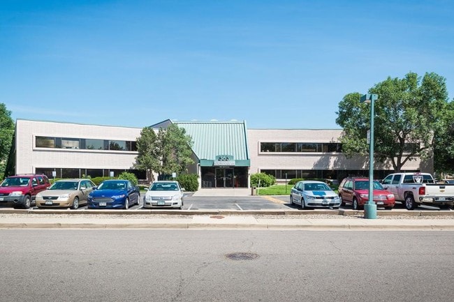
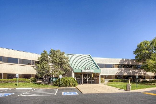
Property Record
363 S Harlan St, Lakewood, CO 80226

Current Lease Availabilities
NEARBY LISTINGS FOR SALE OR LEASE
Property Detail
363 S Harlan St
Denver-Aurora-Lakewood, CO
Alameda Acres Flg #2
49-132-01-029
SECTION 13 TOWNSHIP 04 RANGE 69 QTR NW SUBDIVISIONCD 011000 SUBDIVISIONNAME ALAMEDA ACRES FLG #2 LOT 0001 SIZE: 61155 VALUE: 1.404
Commercialnec
Jefferson
AE
Colorado
08059C0304G
1
2021
1.40 AC
2024
Southwest Denver
011806
Denver
29,471 SF
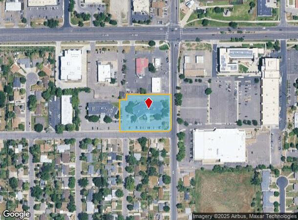
DEMOGRAPHICS near 363 S Harlan St
1 Mile
3 Mile
5 Mile
2024 Total Population
20,240
162,450
442,879
2029 Population
20,110
162,376
444,853
Pop Growth 2024-2029
(0.64%)
(0.05%)
+ 0.45%
Average Age
38
38
39
2024 Total Households
8,335
62,554
201,724
HH Growth 2024-2029
(0.64%)
(0.05%)
+ 0.61%
Median Household Inc
$57,835
$66,089
$77,738
Avg Household Size
2.30
2.40
2.10
2024 Avg HH Vehicles
2.00
2.00
2.00
Median Home Value
$416,840
$443,754
$516,291
Median Year Built
1972
1964
1971
Nearby Places
Map Layers
Map Styles
 Street
 Aerial
- Restaurants
- Banks
- Shops
- Fitness
- Groceries
PUBLIC TRANSPORTATION
COMMUTER RAIL
Union Station: LoDo-Coors Field-16th Street Mall (C Line - Denver Regional Transportation District Light Rail (TheRide), E Line - Denver Regional Transportation District Light Rail (TheRide), W Line - Denver Regional Transportation District Light Rail (TheRide))
DRIVE
WALK
Distance
Union Station: LoDo-Coors Field-16th Street Mall (C Line - Denver Regional Transportation District Light Rail (TheRide), E Line - Denver Regional Transportation District Light Rail (TheRide), W Line - Denver Regional Transportation District Light Rail (TheRide))
13 min
6.3 mi
DRIVE
WALK
Distance
13 min
6.3 mi
AIRPORT
Denver International
DRIVE
WALK
Distance
Denver International
42 min
30.4 mi
Nearby Properties
Address
Land Use
TOTAL SIZE
Lot Size
Zoning
Address
Land Use
TOTAL SIZE
Lot Size
Zoning
113,932 SF
9.60 AC
I-B
Address
Land Use
TOTAL SIZE
Lot Size
Zoning
333,925 SF
3.34 AC
C-MX-5
Address
Land Use
TOTAL SIZE
Lot Size
Zoning
232,678 SF
27.50 AC
Address
Land Use
TOTAL SIZE
Lot Size
Zoning
175,000 SF
2.99 AC
C-MX
Address
Land Use
TOTAL SIZE
Lot Size
Zoning
233,688 SF
22.37 AC
Address
Land Use
TOTAL SIZE
Lot Size
Zoning
325,844 SF
4.08 AC
C-MX-12
Address
Land Use
TOTAL SIZE
Lot Size
Zoning
199,685 SF
27.73 AC
Address
Land Use
TOTAL SIZE
Lot Size
Zoning
368,527 SF
18.71 AC
S-SU-D
Address
Land Use
TOTAL SIZE
Lot Size
Zoning
247,459 SF
2.31 AC
C-MX-8
Address
Land Use
TOTAL SIZE
Lot Size
Zoning
202,867 SF
2.28 AC
C-MX
Address
Land Use
TOTAL SIZE
Lot Size
Zoning
238,452 SF
8.03 AC
Address
Land Use
TOTAL SIZE
Lot Size
Zoning
339,907 SF
11.18 AC
I-A
Address
Land Use
TOTAL SIZE
Lot Size
Zoning
135,372 SF
11.66 AC
Address
Land Use
TOTAL SIZE
Lot Size
Zoning
100,615 SF
2.28 AC
Address
Land Use
TOTAL SIZE
Lot Size
Zoning
82,756 SF
14.95 AC
Address
Land Use
TOTAL SIZE
Lot Size
Zoning
319,365 SF
11.60 AC
Address
Land Use
TOTAL SIZE
Lot Size
Zoning
86,431 SF
6.48 AC
G-MU-3
Address
Land Use
TOTAL SIZE
Lot Size
Zoning
311,200 SF
0.85 AC
Address
Land Use
TOTAL SIZE
Lot Size
Zoning
174,060 SF
2.24 AC
U-SU-C
Address
Land Use
TOTAL SIZE
Lot Size
Zoning
138,204 SF
3.68 AC
Address
Land Use
TOTAL SIZE
Lot Size
Zoning
146,133 SF
3.75 AC
Address
Land Use
TOTAL SIZE
Lot Size
Zoning
153,093 SF
9.02 AC
R-1
Address
Land Use
TOTAL SIZE
Lot Size
Zoning
227,321 SF
5.65 AC
R-3
Address
Land Use
TOTAL SIZE
Lot Size
Zoning
342,370 SF
2.52 AC
C-MX-5
Address
Land Use
TOTAL SIZE
Lot Size
Zoning
245,760 SF
1.48 AC
C-MS
Address
Land Use
TOTAL SIZE
Lot Size
Zoning
7,826 SF
0.48 AC
Address
Land Use
TOTAL SIZE
Lot Size
Zoning
80,616 SF
2.21 AC
Address
Land Use
TOTAL SIZE
Lot Size
Zoning
54,353 SF
2.73 AC
Address
Land Use
TOTAL SIZE
Lot Size
Zoning
157,469 SF
13.02 AC
S-SU-D
Address
Land Use
TOTAL SIZE
Lot Size
Zoning
68,758 SF
8.15 AC
E-SU-D1X
The World's #1 Commercial Real Estate Marketplace
Connect with us
© 2026 CoStar Group
The information above has been obtained from sources believed reliable. While we do not doubt its accuracy we have not verified it and make no guarantee, warranty or representation about it. It is your responsibility to independently confirm its accuracy and completeness. Any projections, opinions, assumptions, or estimates used are for example only and do not represent the current or future performance of the property. The value of this transaction to you depends on tax and other factors which should be evaluated by your tax, financial, and legal advisors. You and your advisors should conduct a careful, independent investigation of the property to determine to your satisfaction the suitability of the property for your needs.