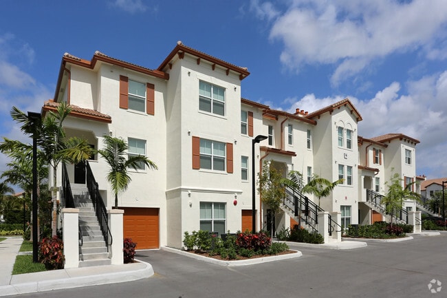
Property Record
3645 W 98Th St, Hialeah, FL 33018


Save to a Folder
{{folder.Name}}
{{folder.ListingIds.length}} Properties
{{folder.ListingIds.length}} Property
Create a New Folder
Property Detail
3645 W 98Th St
04-2021-031-8630
BONTERRA PB 171-064 T-23557 TR E LOT SIZE 610570 SQ FT M/L FAU 04 2021 001 0335 & 0337
Apartmenthouse5plusunits
MIAMI/DADE
8000
Florida
AE The base floodplain where base flood elevations are provided. AE Zones are now used on new format FIRMs instead of A1-A30 Zones.
14.02 AC
2025
Outlying Miami-Dade County
2025
South Florida
012701
Miami-Miami Beach-Kendall, FL
399,805 SF
NEARBY LISTINGS FOR SALE OR LEASE
DEMOGRAPHICS near 3645 W 98Th St
1 mile
3 mile
5 mile
2025 Total Population
15,168
124,113
328,087
2030 Population
16,553
132,134
349,867
Pop Growth 2025-2030
+ 9.13%
+ 6.46%
+ 6.64%
Average Age
37
41
41
2025 Total Households
4,448
39,355
106,277
HH Growth 2025-2030
+ 8.90%
+ 6.35%
+ 6.56%
Median Household Inc
$124,777
$88,080
$75,740
Avg Household Size
3.30
3.10
3.00
2025 Avg HH Vehicles
2.00
2.00
2.00
Median Home Value
$654,715
$463,229
$464,193
Median Year Built
2011
1992
1988
Nearby Places
Map Layers
Map Styles
 Street
 Aerial
Layers
 Traffic
 Biking
Places
Listings with unknown addresses are not visible on the map
- Restaurants
- Banks
- Shops
- Fitness
- Groceries
PUBLIC TRANSPORTATION
COMMUTER RAIL
Palmetto (Metrorail Green Line - Miami-Dade Transit (Metrorail/Metromover))
Drive
Walk
Distance
Palmetto (Metrorail Green Line - Miami-Dade Transit (Metrorail/Metromover))
12 min
6.5 mi
Okeechobee (Metrorail Green Line - Miami-Dade Transit (Metrorail/Metromover))
Drive
Walk
Distance
Okeechobee (Metrorail Green Line - Miami-Dade Transit (Metrorail/Metromover))
14 min
7.4 mi
AIRPORT
Miami International
Drive
Walk
Distance
Miami International
24 min
12.2 mi
Fort Lauderdale/Hollywood International
Drive
Walk
Distance
Fort Lauderdale/Hollywood International
35 min
24.1 mi
Freight Ports
Port of Miami
Drive
Walk
Distance
Port of Miami
35 min
20.4 mi
Nearby Properties
Address
Land Use
TOTAL SIZE
Lot Size
Zoning
Address
Land Use
TOTAL SIZE
Lot Size
Zoning
636,721 SF
52.61 AC
2800
Address
Land Use
TOTAL SIZE
Lot Size
Zoning
483,328 SF
63.80 AC
7701
Address
Land Use
TOTAL SIZE
Lot Size
Zoning
507,170 SF
23.13 AC
7100
Address
Land Use
TOTAL SIZE
Lot Size
Zoning
724,587 SF
48.54 AC
7701
Address
Land Use
TOTAL SIZE
Lot Size
Zoning
572,062 SF
38.15 AC
9400
Address
Land Use
TOTAL SIZE
Lot Size
Zoning
439,520 SF
20.20 AC
9400
Address
Land Use
TOTAL SIZE
Lot Size
Zoning
595,768 SF
33.42 AC
7600
Address
Land Use
TOTAL SIZE
Lot Size
Zoning
725,624 SF
34.80 AC
7300
Address
Land Use
TOTAL SIZE
Lot Size
Zoning
526,059 SF
18.99 AC
6407
Address
Land Use
TOTAL SIZE
Lot Size
Zoning
469,837 SF
26 AC
7600
Address
Land Use
TOTAL SIZE
Lot Size
Zoning
812,314 SF
44 AC
7600
Address
Land Use
TOTAL SIZE
Lot Size
Zoning
509,271 SF
28.69 AC
7701
Address
Land Use
TOTAL SIZE
Lot Size
Zoning
374,816 SF
21.41 AC
7701
Address
Land Use
TOTAL SIZE
Lot Size
Zoning
359,483 SF
11.34 AC
8000
Address
Land Use
TOTAL SIZE
Lot Size
Zoning
223,543 SF
39.40 AC
6407
Address
Land Use
TOTAL SIZE
Lot Size
Zoning
307,032 SF
20.08 AC
7701
Address
Land Use
TOTAL SIZE
Lot Size
Zoning
537,862 SF
22.21 AC
7701
Address
Land Use
TOTAL SIZE
Lot Size
Zoning
333,414 SF
24.20 AC
7701
Address
Land Use
TOTAL SIZE
Lot Size
Zoning
345,413 SF
10.48 AC
9000
Address
Land Use
TOTAL SIZE
Lot Size
Zoning
298,578 SF
15.95 AC
7701
Address
Land Use
TOTAL SIZE
Lot Size
Zoning
382,421 SF
19.66 AC
3700
Address
Land Use
TOTAL SIZE
Lot Size
Zoning
672,678 SF
38.88 AC
7100
Address
Land Use
TOTAL SIZE
Lot Size
Zoning
627,014 SF
48.58 AC
7100
Address
Land Use
TOTAL SIZE
Lot Size
Zoning
400,062 SF
33.33 AC
0101
Address
Land Use
TOTAL SIZE
Lot Size
Zoning
315,033 SF
11.48 AC
6109
Address
Land Use
TOTAL SIZE
Lot Size
Zoning
267,601 SF
16.81 AC
7100
Address
Land Use
TOTAL SIZE
Lot Size
Zoning
235,248 SF
12.31 AC
7600
Address
Land Use
TOTAL SIZE
Lot Size
Zoning
230,147 SF
15 AC
7701
Address
Land Use
TOTAL SIZE
Lot Size
Zoning
230,169 SF
10.62 AC
7600
The World's #1 Commercial Real Estate Marketplace
Connect with us
© 2026 CoStar Group
The information above has been obtained from sources believed reliable. While we do not doubt its accuracy we have not verified it and make no guarantee, warranty or representation about it. It is your responsibility to independently confirm its accuracy and completeness. Any projections, opinions, assumptions, or estimates used are for example only and do not represent the current or future performance of the property. The value of this transaction to you depends on tax and other factors which should be evaluated by your tax, financial, and legal advisors. You and your advisors should conduct a careful, independent investigation of the property to determine to your satisfaction the suitability of the property for your needs.