Property Record
365 5Th St, San Francisco, CA 94107
NEARBY LISTINGS FOR SALE OR LEASE
Property Detail
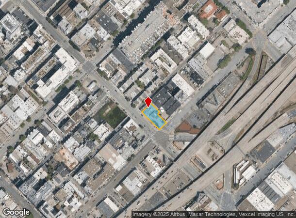
365 5Th St
San Francisco-Redwood City-South San Francisco, CA
San Francisco
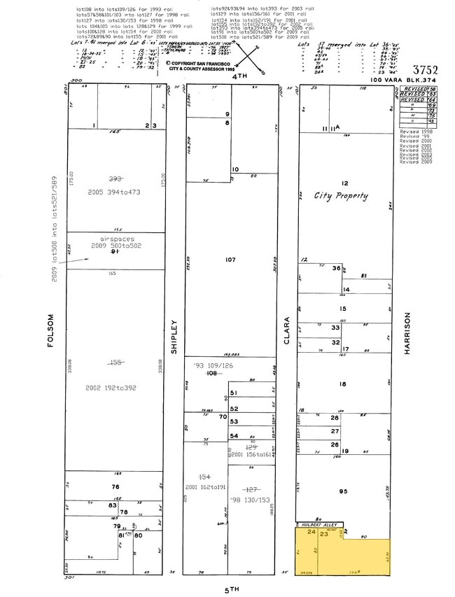
3752-590
California
Residentialacreage
590
2024
0.26 AC
2025
Yerba Buena
060701
San Francisco
DEMOGRAPHICS near 365 5Th St
1 Mile
3 Mile
5 Mile
2024 Total Population
110,807
434,379
682,384
2029 Population
104,238
405,290
631,800
Pop Growth 2024-2029
(5.93%)
(6.70%)
(7.41%)
Average Age
41
42
42
2024 Total Households
55,955
210,706
298,557
HH Growth 2024-2029
(6.59%)
(7.24%)
(7.77%)
Median Household Inc
$95,819
$130,780
$128,516
Avg Household Size
1.70
1.90
2.10
2024 Avg HH Vehicles
1.00
1.00
1.00
Median Home Value
$1,068,894
$1,101,244
$1,099,320
Median Year Built
1992
1949
1949
Nearby Places
Map Layers
Map Styles
 Street
 Aerial
- Restaurants
- Banks
- Shops
- Fitness
- Groceries
PUBLIC TRANSPORTATION
TRANSIT/SUBWAY
Market and 5th (F Market - San Francisco Municipal Railway (MUNI Metro))
DRIVE
WALK
Distance
Market and 5th (F Market - San Francisco Municipal Railway (MUNI Metro))
3 min
9 min
0.5 mi
Powell Station (J Church - San Francisco Municipal Railway (MUNI Metro), K Ingleside - San Francisco Municipal Railway (MUNI Metro), L Taraval - San Francisco Municipal Railway (MUNI Metro), M Ocean View - San Francisco Municipal Railway (MUNI Metro), N Judah - San Francisco Municipal Railway (MUNI Metro), S Castro Shuttle - San Francisco Municipal Railway (MUNI Metro), T Third Street - San Francisco Municipal Railway (MUNI Metro))
DRIVE
WALK
Distance
Powell Station (J Church - San Francisco Municipal Railway (MUNI Metro), K Ingleside - San Francisco Municipal Railway (MUNI Metro), L Taraval - San Francisco Municipal Railway (MUNI Metro), M Ocean View - San Francisco Municipal Railway (MUNI Metro), N Judah - San Francisco Municipal Railway (MUNI Metro), S Castro Shuttle - San Francisco Municipal Railway (MUNI Metro), T Third Street - San Francisco Municipal Railway (MUNI Metro))
3 min
11 min
0.5 mi
San Francisco 4th & King (Caltrain - Caltrain (Caltrain))
DRIVE
WALK
Distance
San Francisco 4th & King (Caltrain - Caltrain (Caltrain))
2 min
12 min
0.6 mi
Market and 4th/Stockton (F Market - San Francisco Municipal Railway (MUNI Metro))
DRIVE
WALK
Distance
Market and 4th/Stockton (F Market - San Francisco Municipal Railway (MUNI Metro))
4 min
12 min
0.6 mi
4th and King (N Line) (N Judah - San Francisco Municipal Railway (MUNI Metro))
DRIVE
WALK
Distance
4th and King (N Line) (N Judah - San Francisco Municipal Railway (MUNI Metro))
2 min
13 min
0.7 mi
COMMUTER RAIL
San Francisco 4th & King (Caltrain - Caltrain (Caltrain))
DRIVE
WALK
Distance
San Francisco 4th & King (Caltrain - Caltrain (Caltrain))
2 min
11 min
0.6 mi
DRIVE
WALK
Distance
2 min
12 min
0.6 mi
AIRPORT
San Francisco International
DRIVE
WALK
Distance
San Francisco International
21 min
13.3 mi
Metro Oakland International
DRIVE
WALK
Distance
Metro Oakland International
29 min
19.1 mi
Norman Y Mineta San Jose International
DRIVE
WALK
Distance
Norman Y Mineta San Jose International
56 min
44.9 mi
Freight Ports
Port of San Francisco
DRIVE
WALK
Distance
Port of San Francisco
6 min
2.2 mi
Nearby Properties
Address
Land Use
TOTAL SIZE
Lot Size
Zoning
Address
Land Use
TOTAL SIZE
Lot Size
Zoning
1,015,000 SF
2.43 AC
RC4
Address
Land Use
TOTAL SIZE
Lot Size
Zoning
764,661 SF
0.67 AC
C3OSD
Address
Land Use
TOTAL SIZE
Lot Size
Zoning
750,370 SF
3.25 AC
MBR3
Address
Land Use
TOTAL SIZE
Lot Size
Zoning
1,471,929 SF
1.93 AC
C3O
Address
Land Use
TOTAL SIZE
Lot Size
Zoning
1,300,000 SF
1.74 AC
C3O
Address
Land Use
TOTAL SIZE
Lot Size
Zoning
1,420,430 SF
1.16 AC
C3OSD
Address
Land Use
TOTAL SIZE
Lot Size
Zoning
1,534,312 SF
2.60 AC
C3O
Address
Land Use
TOTAL SIZE
Lot Size
Zoning
914,037 SF
1.36 AC
C3O
Address
Land Use
TOTAL SIZE
Lot Size
Zoning
248,303 SF
4.35 AC
Address
Land Use
TOTAL SIZE
Lot Size
Zoning
717,234 SF
3.47 AC
UMU
Address
Land Use
TOTAL SIZE
Lot Size
Zoning
605,459 SF
0.63 AC
C3O
Address
Land Use
TOTAL SIZE
Lot Size
Zoning
475,791 SF
0.55 AC
C3OSD
Address
Land Use
TOTAL SIZE
Lot Size
Zoning
690,442 SF
0.79 AC
C3O
Address
Land Use
TOTAL SIZE
Lot Size
Zoning
10.92 AC
Address
Land Use
TOTAL SIZE
Lot Size
Zoning
750,491 SF
0.51 AC
C3O
Address
Land Use
TOTAL SIZE
Lot Size
Zoning
432,000 SF
0.35 AC
C3OSD
Address
Land Use
TOTAL SIZE
Lot Size
Zoning
266,143 SF
4 AC
C-3-R
Address
Land Use
TOTAL SIZE
Lot Size
Zoning
885,581 SF
5.20 AC
M2
Address
Land Use
TOTAL SIZE
Lot Size
Zoning
512,395 SF
1.24 AC
C3O
Address
Land Use
TOTAL SIZE
Lot Size
Zoning
508,714 SF
1.29 AC
C3R
Address
Land Use
TOTAL SIZE
Lot Size
Zoning
1,084,662 SF
1.67 AC
C3O
Address
Land Use
TOTAL SIZE
Lot Size
Zoning
505,120 SF
0.41 AC
C3O
Address
Land Use
TOTAL SIZE
Lot Size
Zoning
694,334 SF
1.01 AC
C3O
Address
Land Use
TOTAL SIZE
Lot Size
Zoning
696,431 SF
0.97 AC
C3G
Address
Land Use
TOTAL SIZE
Lot Size
Zoning
139,070 SF
0.64 AC
C3O
Address
Land Use
TOTAL SIZE
Lot Size
Zoning
1.52 AC
C3G
Address
Land Use
TOTAL SIZE
Lot Size
Zoning
1,424,230 SF
2.60 AC
C3G
Address
Land Use
TOTAL SIZE
Lot Size
Zoning
614,740 SF
1.74 AC
C3OSD
Address
Land Use
TOTAL SIZE
Lot Size
Zoning
615,957 SF
0.63 AC
C3O
Address
Land Use
TOTAL SIZE
Lot Size
Zoning
492,980 SF
0.43 AC
C3O
The World's #1 Commercial Real Estate Marketplace
Connect with us
© 2026 CoStar Group
The information above has been obtained from sources believed reliable. While we do not doubt its accuracy we have not verified it and make no guarantee, warranty or representation about it. It is your responsibility to independently confirm its accuracy and completeness. Any projections, opinions, assumptions, or estimates used are for example only and do not represent the current or future performance of the property. The value of this transaction to you depends on tax and other factors which should be evaluated by your tax, financial, and legal advisors. You and your advisors should conduct a careful, independent investigation of the property to determine to your satisfaction the suitability of the property for your needs.