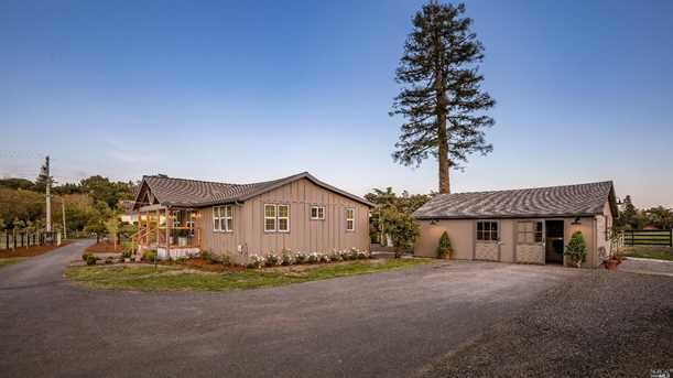
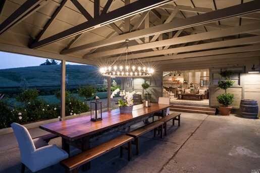
Property Record
365 King Rd, Petaluma, CA 94952
Property Detail
365 King Rd
113-090-031
81 FORM PT OF 113-090-07 PM 6786, PCL 4
Multifamilydwelling
Sonoma
AR3
California
B and X Area of moderate flood hazard, usually the area between the limits of the 100-year and 500-year floods.
8 AC
2025
Petaluma/Cotati/Rohnert
2025
North Bay/Santa Rosa
151100
Santa Rosa-Petaluma, CA
720 SF
NEARBY LISTINGS FOR SALE OR LEASE
-
-
View all Petaluma listings for sale on LoopNet.com
DEMOGRAPHICS near 365 King Rd
1 mile
3 mile
5 mile
2025 Total Population
834
5,061
63,115
2030 Population
773
4,730
62,593
Pop Growth 2025-2030
(7.31%)
(6.54%)
(0.83%)
Average Age
47
46
42
2025 Total Households
328
2,024
24,207
HH Growth 2025-2030
(7.32%)
(6.67%)
(0.87%)
Median Household Inc
$143,055
$108,116
$105,174
Avg Household Size
2.50
2.40
2.50
2025 Avg HH Vehicles
3.00
2.00
2.00
Median Home Value
$1,119,841
$1,077,878
$810,386
Median Year Built
1972
1972
1980
Nearby Places
Map Layers
Map Styles
 Street
 Aerial
Layers
 Traffic
 Biking
Places
Listings with unknown addresses are not visible on the map
- Restaurants
- Banks
- Shops
- Fitness
- Groceries
PUBLIC TRANSPORTATION
COMMUTER RAIL
Smart Petaluma North (Main Line - Sonoma Marin Area Rail Transit)
Drive
Walk
Distance
Smart Petaluma North (Main Line - Sonoma Marin Area Rail Transit)
11 min
5.1 mi
Smart Cotati (Main Line - Sonoma Marin Area Rail Transit)
Drive
Walk
Distance
Smart Cotati (Main Line - Sonoma Marin Area Rail Transit)
13 min
5.7 mi
AIRPORT
Charles M Schulz - Sonoma County
Drive
Walk
Distance
Charles M Schulz - Sonoma County
32 min
20.6 mi
Freight Ports
Port of Richmond
Drive
Walk
Distance
Port of Richmond
54 min
39.3 mi
SALE & LEASE HISTORY
LISTING DATE
SALE/LEASE

Jul 09, 2018
For Sale
Nearby Properties
Address
Land Use
TOTAL SIZE
Lot Size
Zoning
Address
Land Use
TOTAL SIZE
Lot Size
Zoning
389.05 AC
Address
Land Use
TOTAL SIZE
Lot Size
Zoning
83,653 SF
1.18 AC
Address
Land Use
TOTAL SIZE
Lot Size
Zoning
88,482 SF
7.29 AC
Address
Land Use
TOTAL SIZE
Lot Size
Zoning
32,288 SF
2.59 AC
CITYPE
Address
Land Use
TOTAL SIZE
Lot Size
Zoning
71,884 SF
0.65 AC
Address
Land Use
TOTAL SIZE
Lot Size
Zoning
141,168 SF
9.44 AC
18
Address
Land Use
TOTAL SIZE
Lot Size
Zoning
54,637 SF
0.66 AC
Address
Land Use
TOTAL SIZE
Lot Size
Zoning
58,299 SF
0.72 AC
Address
Land Use
TOTAL SIZE
Lot Size
Zoning
44,244 SF
3.44 AC
Address
Land Use
TOTAL SIZE
Lot Size
Zoning
Address
Land Use
TOTAL SIZE
Lot Size
Zoning
1,260 SF
66.88 AC
LEA60
Address
Land Use
TOTAL SIZE
Lot Size
Zoning
42,388 SF
1.11 AC
CITYPE
Address
Land Use
TOTAL SIZE
Lot Size
Zoning
57,340 SF
3.82 AC
CITYPE
Address
Land Use
TOTAL SIZE
Lot Size
Zoning
42,000 SF
2.24 AC
Address
Land Use
TOTAL SIZE
Lot Size
Zoning
7,104 SF
1 AC
CITYPE
Address
Land Use
TOTAL SIZE
Lot Size
Zoning
41,722 SF
3.08 AC
CITYPE
Address
Land Use
TOTAL SIZE
Lot Size
Zoning
15,038 SF
3.58 AC
PCD
Address
Land Use
TOTAL SIZE
Lot Size
Zoning
25,404 SF
4.39 AC
Address
Land Use
TOTAL SIZE
Lot Size
Zoning
41,440 SF
0.48 AC
Address
Land Use
TOTAL SIZE
Lot Size
Zoning
24,000 SF
2.50 AC
CITYPE
Address
Land Use
TOTAL SIZE
Lot Size
Zoning
16,342 SF
3.09 AC
Address
Land Use
TOTAL SIZE
Lot Size
Zoning
39,924 SF
1.96 AC
Address
Land Use
TOTAL SIZE
Lot Size
Zoning
29,900 SF
0.69 AC
Address
Land Use
TOTAL SIZE
Lot Size
Zoning
24,132 SF
2.63 AC
Address
Land Use
TOTAL SIZE
Lot Size
Zoning
1,440 SF
25.21 AC
Address
Land Use
TOTAL SIZE
Lot Size
Zoning
66,656 SF
0.37 AC
Address
Land Use
TOTAL SIZE
Lot Size
Zoning
71,884 SF
0.59 AC
Address
Land Use
TOTAL SIZE
Lot Size
Zoning
7,800 SF
12.18 AC
Address
Land Use
TOTAL SIZE
Lot Size
Zoning
57,937 SF
1.02 AC
CITYPE
Address
Land Use
TOTAL SIZE
Lot Size
Zoning
15,600 SF
0.98 AC
The World's #1 Commercial Real Estate Marketplace
Connect with us
© 2026 CoStar Group
The information above has been obtained from sources believed reliable. While we do not doubt its accuracy we have not verified it and make no guarantee, warranty or representation about it. It is your responsibility to independently confirm its accuracy and completeness. Any projections, opinions, assumptions, or estimates used are for example only and do not represent the current or future performance of the property. The value of this transaction to you depends on tax and other factors which should be evaluated by your tax, financial, and legal advisors. You and your advisors should conduct a careful, independent investigation of the property to determine to your satisfaction the suitability of the property for your needs.