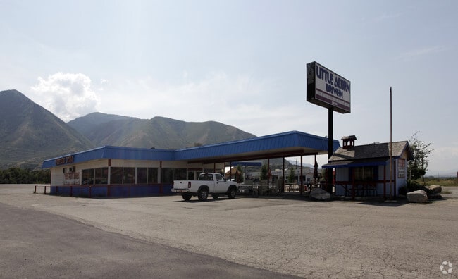
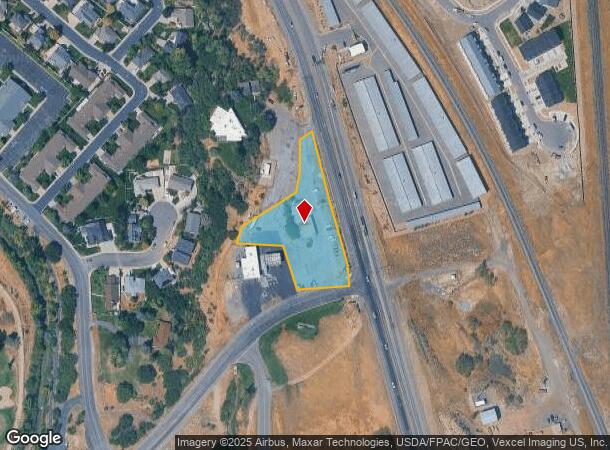
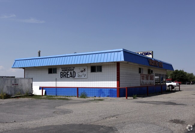
Property Record
3660 E Highway 6 Hwy, Spanish Fork, UT 84660
NEARBY LISTINGS FOR SALE OR LEASE
Property Detail
3660 E Highway 6 Hwy
Provo-Orem, UT
COM N 200.666 FT & E 1206.233 FT FR SW COR SEC 27, T8S, R3E, SLM; S 15 DEG 2131E 206.944 FT; S 4 DEG 4926E 62.578 FT; S 84 DEG 5401W 158.39 FT; N 17 DEG 1820W 139.59 FT; N 87 DEG 1015W 137.98 FT; N 25 DEG 5129E 6.69 FT; N 15 DEG 5738E 45.95 FT; N 57
27-037-0044
Utah
Commercialnec
Utah
2024
1.58 AC
2025
Utah County
003204
Salt Lake City
2,447 SF
DEMOGRAPHICS near 3660 E Highway 6 Hwy
1 Mile
3 Mile
5 Mile
2024 Total Population
4,046
33,958
81,436
2029 Population
4,729
39,825
95,493
Pop Growth 2024-2029
+ 16.88%
+ 17.28%
+ 17.26%
Average Age
32
31
32
2024 Total Households
1,051
8,628
21,816
HH Growth 2024-2029
+ 17.32%
+ 17.70%
+ 17.60%
Median Household Inc
$89,923
$107,478
$98,566
Avg Household Size
3.90
3.90
3.70
2024 Avg HH Vehicles
3.00
3.00
3.00
Median Home Value
$390,058
$463,958
$461,841
Median Year Built
2004
2005
2001
Nearby Places
Map Layers
Map Styles
 Street
 Aerial
- Restaurants
- Banks
- Shops
- Fitness
- Groceries
PUBLIC TRANSPORTATION
AIRPORT
Provo Municipal
DRIVE
WALK
Distance
Provo Municipal
19 min
13.4 mi
Freight Ports
Port of Stockton
DRIVE
WALK
Distance
Port of Stockton
768 min
750.0 mi
SALE & LEASE HISTORY
LISTING DATE
SALE/LEASE

Apr 11, 2024
For Lease
Nearby Properties
Address
Land Use
TOTAL SIZE
Lot Size
Zoning
Address
Land Use
TOTAL SIZE
Lot Size
Zoning
10,479 SF
69.93 AC
RA5
Address
Land Use
TOTAL SIZE
Lot Size
Zoning
49,436 SF
6.30 AC
Address
Land Use
TOTAL SIZE
Lot Size
Zoning
88,763 SF
5.89 AC
Address
Land Use
TOTAL SIZE
Lot Size
Zoning
54,208 SF
20.51 AC
Address
Land Use
TOTAL SIZE
Lot Size
Zoning
83,171 SF
2.85 AC
Address
Land Use
TOTAL SIZE
Lot Size
Zoning
49,722 SF
1.60 AC
Address
Land Use
TOTAL SIZE
Lot Size
Zoning
36,021 SF
1.54 AC
Address
Land Use
TOTAL SIZE
Lot Size
Zoning
67,146 SF
4.26 AC
Address
Land Use
TOTAL SIZE
Lot Size
Zoning
75,796 SF
3.07 AC
Address
Land Use
TOTAL SIZE
Lot Size
Zoning
5,758 SF
3.08 AC
Address
Land Use
TOTAL SIZE
Lot Size
Zoning
11,487 SF
1.30 AC
Address
Land Use
TOTAL SIZE
Lot Size
Zoning
4,540 SF
1.48 AC
Address
Land Use
TOTAL SIZE
Lot Size
Zoning
15.97 AC
Address
Land Use
TOTAL SIZE
Lot Size
Zoning
27,916 SF
1.37 AC
Address
Land Use
TOTAL SIZE
Lot Size
Zoning
16.07 AC
Address
Land Use
TOTAL SIZE
Lot Size
Zoning
18,698 SF
1.65 AC
Address
Land Use
TOTAL SIZE
Lot Size
Zoning
11,384 SF
5 AC
Address
Land Use
TOTAL SIZE
Lot Size
Zoning
20,659 SF
0.28 AC
Address
Land Use
TOTAL SIZE
Lot Size
Zoning
11,642 SF
0.22 AC
Address
Land Use
TOTAL SIZE
Lot Size
Zoning
17,864 SF
1.54 AC
Address
Land Use
TOTAL SIZE
Lot Size
Zoning
10 AC
RA5
Address
Land Use
TOTAL SIZE
Lot Size
Zoning
8,734 SF
0.99 AC
Address
Land Use
TOTAL SIZE
Lot Size
Zoning
19,616 SF
5 AC
Address
Land Use
TOTAL SIZE
Lot Size
Zoning
21,323 SF
1.70 AC
Address
Land Use
TOTAL SIZE
Lot Size
Zoning
12,040 SF
2.53 AC
Address
Land Use
TOTAL SIZE
Lot Size
Zoning
3,837 SF
1.14 AC
Address
Land Use
TOTAL SIZE
Lot Size
Zoning
11,552 SF
5.32 AC
RR5
Address
Land Use
TOTAL SIZE
Lot Size
Zoning
12,201 SF
4.82 AC
Address
Land Use
TOTAL SIZE
Lot Size
Zoning
9,218 SF
8.64 AC
RA5
Address
Land Use
TOTAL SIZE
Lot Size
Zoning
5,048 SF
3.65 AC
RA5
The World's #1 Commercial Real Estate Marketplace
Connect with us
© 2025 CoStar Group
The information above has been obtained from sources believed reliable. While we do not doubt its accuracy we have not verified it and make no guarantee, warranty or representation about it. It is your responsibility to independently confirm its accuracy and completeness. Any projections, opinions, assumptions, or estimates used are for example only and do not represent the current or future performance of the property. The value of this transaction to you depends on tax and other factors which should be evaluated by your tax, financial, and legal advisors. You and your advisors should conduct a careful, independent investigation of the property to determine to your satisfaction the suitability of the property for your needs.