Property Record
375 W Highway 78, Temple, GA 30179

NEARBY LISTINGS FOR SALE OR LEASE
Property Detail
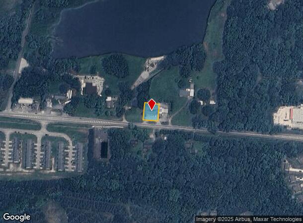
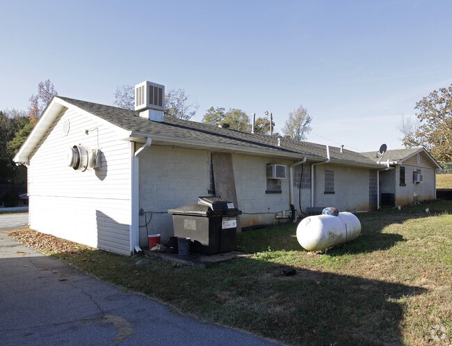
375 W Highway 78
T02-0050029
COMM BLDG/.24AC/HWY 78 W T2
Restaurantbuilding
Carroll
X
Georgia
13143C0260B
0.24 AC
2025
W Carroll County
2025
Atlanta
910201
Atlanta-Sandy Springs-Roswell, GA
2,242 SF
DEMOGRAPHICS near 375 W Highway 78
1 Mile
3 Mile
5 Mile
2024 Total Population
2,625
11,855
22,489
2029 Population
2,963
13,299
25,121
Pop Growth 2024-2029
+ 12.88%
+ 12.18%
+ 11.70%
Average Age
37
37
38
2024 Total Households
909
4,119
7,859
HH Growth 2024-2029
+ 12.98%
+ 12.26%
+ 11.80%
Median Household Inc
$73,369
$70,327
$67,835
Avg Household Size
2.80
2.80
2.80
2024 Avg HH Vehicles
2.00
2.00
2.00
Median Home Value
$194,244
$201,210
$213,609
Median Year Built
1995
1997
1995
Nearby Places
Map Layers
Map Styles
 Street
 Aerial
- Restaurants
- Banks
- Shops
- Fitness
- Groceries
Nearby Properties
Address
Land Use
TOTAL SIZE
Lot Size
Zoning
Address
Land Use
TOTAL SIZE
Lot Size
Zoning
228,640 SF
17.27 AC
I
Address
Land Use
TOTAL SIZE
Lot Size
Zoning
280,118 SF
22.72 AC
I
Address
Land Use
TOTAL SIZE
Lot Size
Zoning
83,083 SF
11.21 AC
GC
Address
Land Use
TOTAL SIZE
Lot Size
Zoning
138,953 SF
18.97 AC
RD
Address
Land Use
TOTAL SIZE
Lot Size
Zoning
25,562 SF
7.81 AC
R14
Address
Land Use
TOTAL SIZE
Lot Size
Zoning
102,856 SF
13.13 AC
I
Address
Land Use
TOTAL SIZE
Lot Size
Zoning
17,182 SF
27.39 AC
GC
Address
Land Use
TOTAL SIZE
Lot Size
Zoning
138.26 AC
A
Address
Land Use
TOTAL SIZE
Lot Size
Zoning
24,904 SF
9.93 AC
GC
Address
Land Use
TOTAL SIZE
Lot Size
Zoning
86,167 SF
6.90 AC
RD
Address
Land Use
TOTAL SIZE
Lot Size
Zoning
37,169 SF
3.18 AC
I
Address
Land Use
TOTAL SIZE
Lot Size
Zoning
3,096 SF
6.86 AC
GC
Address
Land Use
TOTAL SIZE
Lot Size
Zoning
2,220 SF
8.88 AC
C
Address
Land Use
TOTAL SIZE
Lot Size
Zoning
15.18 AC
001
Address
Land Use
TOTAL SIZE
Lot Size
Zoning
4,345 SF
1.75 AC
GC
Address
Land Use
TOTAL SIZE
Lot Size
Zoning
4,328 SF
5.76 AC
C
Address
Land Use
TOTAL SIZE
Lot Size
Zoning
13,614 SF
2.24 AC
R14
Address
Land Use
TOTAL SIZE
Lot Size
Zoning
27,834 SF
15.28 AC
001
Address
Land Use
TOTAL SIZE
Lot Size
Zoning
53.40 AC
A
Address
Land Use
TOTAL SIZE
Lot Size
Zoning
4,098 SF
1.06 AC
GC
Address
Land Use
TOTAL SIZE
Lot Size
Zoning
10,584 SF
2.99 AC
DCD
Address
Land Use
TOTAL SIZE
Lot Size
Zoning
17,500 SF
8.93 AC
I
Address
Land Use
TOTAL SIZE
Lot Size
Zoning
27,150 SF
3.71 AC
LI
Address
Land Use
TOTAL SIZE
Lot Size
Zoning
3,709 SF
1.06 AC
DCD
Address
Land Use
TOTAL SIZE
Lot Size
Zoning
14,400 SF
2.48 AC
CG
Address
Land Use
TOTAL SIZE
Lot Size
Zoning
26.26 AC
I
Address
Land Use
TOTAL SIZE
Lot Size
Zoning
2,928 SF
0.98 AC
GC
Address
Land Use
TOTAL SIZE
Lot Size
Zoning
40,215 SF
21.92 AC
I
Address
Land Use
TOTAL SIZE
Lot Size
Zoning
1,456 SF
3.55 AC
C
Address
Land Use
TOTAL SIZE
Lot Size
Zoning
21,546 SF
6 AC
I
The World's #1 Commercial Real Estate Marketplace
Connect with us
© 2025 CoStar Group
The information above has been obtained from sources believed reliable. While we do not doubt its accuracy we have not verified it and make no guarantee, warranty or representation about it. It is your responsibility to independently confirm its accuracy and completeness. Any projections, opinions, assumptions, or estimates used are for example only and do not represent the current or future performance of the property. The value of this transaction to you depends on tax and other factors which should be evaluated by your tax, financial, and legal advisors. You and your advisors should conduct a careful, independent investigation of the property to determine to your satisfaction the suitability of the property for your needs.