Property Record
3770/3585 Piazza Dr, Fort Myers, FL 33916

NEARBY LISTINGS FOR SALE OR LEASE
Property Detail
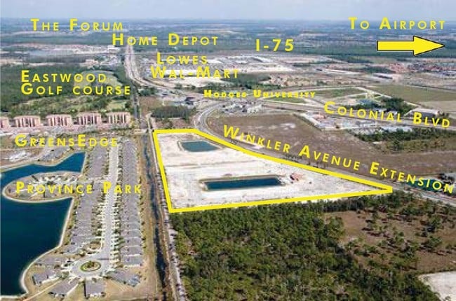
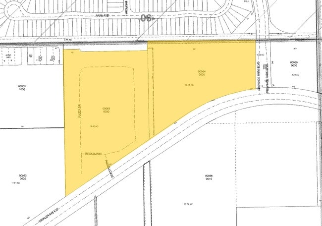
3770/3585 Piazza Dr
Cape Coral-Fort Myers, FL
Colonial Corridor
32-44-25-P2-00063.0030
E 1/2 OF NW 1/4 OF NE 1/4 OF SECT LYING N OF COLONIAL BLVD LESS OR 2383/3971 + NW 1/4 OF NE 1/4 OF NE 1/4 + 3205/4052 LESS N 50 FT R/W + W 40 FT R/W
Orphanage
Lee
AE
Florida
12071C0427G
1-24
2024
24.13 AC
2025
City of Ft Myers
000600
Southwest Florida
275,753 SF
DEMOGRAPHICS near 3770/3585 Piazza Dr
1 Mile
3 Mile
5 Mile
2024 Total Population
9,853
61,548
146,794
2029 Population
11,865
73,761
174,467
Pop Growth 2024-2029
+ 20.42%
+ 19.84%
+ 18.85%
Average Age
37
41
42
2024 Total Households
4,486
24,746
60,465
HH Growth 2024-2029
+ 19.88%
+ 19.82%
+ 18.73%
Median Household Inc
$58,266
$52,750
$57,818
Avg Household Size
2.20
2.30
2.30
2024 Avg HH Vehicles
2.00
1.00
1.00
Median Home Value
$285,765
$279,190
$287,657
Median Year Built
2009
2002
1995
Nearby Places
Map Layers
Map Styles
 Street
 Aerial
- Restaurants
- Banks
- Shops
- Fitness
- Groceries
PUBLIC TRANSPORTATION
AIRPORT
Southwest Florida International
DRIVE
WALK
Distance
Southwest Florida International
17 min
9.7 mi
Punta Gorda
DRIVE
WALK
Distance
Punta Gorda
35 min
28.5 mi
Freight Ports
Port Manatee
DRIVE
WALK
Distance
Port Manatee
115 min
100.2 mi
Nearby Properties
Address
Land Use
TOTAL SIZE
Lot Size
Zoning
Address
Land Use
TOTAL SIZE
Lot Size
Zoning
608,522 SF
38.57 AC
CG
Address
Land Use
TOTAL SIZE
Lot Size
Zoning
438,839 SF
66.95 AC
MU
Address
Land Use
TOTAL SIZE
Lot Size
Zoning
463,722 SF
23.85 AC
C-1
Address
Land Use
TOTAL SIZE
Lot Size
Zoning
689,351 SF
42.34 AC
RM-16/
Address
Land Use
TOTAL SIZE
Lot Size
Zoning
425,522 SF
380.73 AC
IL
Address
Land Use
TOTAL SIZE
Lot Size
Zoning
429,703 SF
16.24 AC
PUD
Address
Land Use
TOTAL SIZE
Lot Size
Zoning
362,391 SF
12.80 AC
SDA
Address
Land Use
TOTAL SIZE
Lot Size
Zoning
475,045 SF
30.22 AC
PUD
Address
Land Use
TOTAL SIZE
Lot Size
Zoning
432,890 SF
18.88 AC
SDA
Address
Land Use
TOTAL SIZE
Lot Size
Zoning
422,099 SF
1.10 AC
CG
Address
Land Use
TOTAL SIZE
Lot Size
Zoning
286,629 SF
13.01 AC
SDA
Address
Land Use
TOTAL SIZE
Lot Size
Zoning
16.13 AC
Address
Land Use
TOTAL SIZE
Lot Size
Zoning
425,658 SF
25.61 AC
CG
Address
Land Use
TOTAL SIZE
Lot Size
Zoning
98,242 SF
17.43 AC
RS-7
Address
Land Use
TOTAL SIZE
Lot Size
Zoning
749,922 SF
41.78 AC
C1
Address
Land Use
TOTAL SIZE
Lot Size
Zoning
304,258 SF
12.20 AC
CG
Address
Land Use
TOTAL SIZE
Lot Size
Zoning
368,722 SF
18.09 AC
CG
Address
Land Use
TOTAL SIZE
Lot Size
Zoning
305,224 SF
17.11 AC
CG
Address
Land Use
TOTAL SIZE
Lot Size
Zoning
694,188 SF
22.43 AC
PUD
Address
Land Use
TOTAL SIZE
Lot Size
Zoning
364,206 SF
106.76 AC
PUD
Address
Land Use
TOTAL SIZE
Lot Size
Zoning
324,346 SF
20 AC
C1
Address
Land Use
TOTAL SIZE
Lot Size
Zoning
9.07 AC
SDA
Address
Land Use
TOTAL SIZE
Lot Size
Zoning
284,371 SF
12.61 AC
CG
Address
Land Use
TOTAL SIZE
Lot Size
Zoning
260,320 SF
8.81 AC
SDA
Address
Land Use
TOTAL SIZE
Lot Size
Zoning
261,340 SF
9.07 AC
CG
Address
Land Use
TOTAL SIZE
Lot Size
Zoning
376,949 SF
49.70 AC
RM16
Address
Land Use
TOTAL SIZE
Lot Size
Zoning
6.99 AC
C-1
Address
Land Use
TOTAL SIZE
Lot Size
Zoning
281,781 SF
12.60 AC
C1
Address
Land Use
TOTAL SIZE
Lot Size
Zoning
13.71 AC
The World's #1 Commercial Real Estate Marketplace
Connect with us
© 2025 CoStar Group
The information above has been obtained from sources believed reliable. While we do not doubt its accuracy we have not verified it and make no guarantee, warranty or representation about it. It is your responsibility to independently confirm its accuracy and completeness. Any projections, opinions, assumptions, or estimates used are for example only and do not represent the current or future performance of the property. The value of this transaction to you depends on tax and other factors which should be evaluated by your tax, financial, and legal advisors. You and your advisors should conduct a careful, independent investigation of the property to determine to your satisfaction the suitability of the property for your needs.