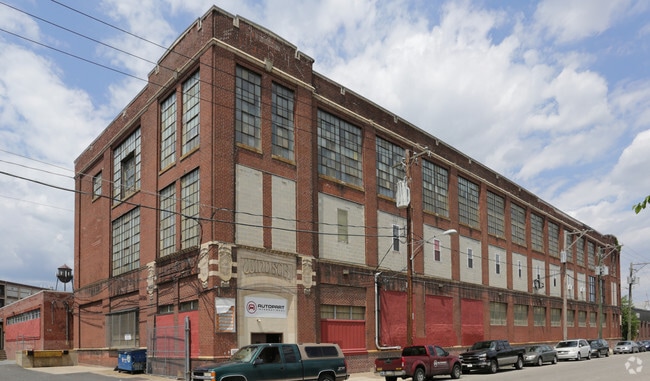
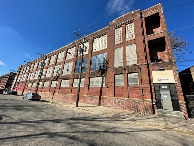
Property Record
3800 Jasper St, Philadelphia, PA 19124

Current Lease Availabilities
NEARBY LISTINGS FOR SALE OR LEASE
Property Detail
3800 Jasper St
884847405
76.479 E KENSINGTON
Warehouse
Philadelphia
X
Pennsylvania
4207570113G
2.02 AC
2024
Kensington
2026
Philadelphia
038200
Philadelphia-Camden-Wilmington, PA-NJ-DE-MD
81,355 SF
DEMOGRAPHICS near 3800 Jasper St
1 Mile
3 Mile
5 Mile
2024 Total Population
35,928
331,022
879,964
2029 Population
34,375
318,374
856,999
Pop Growth 2024-2029
(4.32%)
(3.82%)
(2.61%)
Average Age
35
36
37
2024 Total Households
11,988
118,907
337,858
HH Growth 2024-2029
(4.57%)
(3.95%)
(2.73%)
Median Household Inc
$34,313
$40,526
$48,564
Avg Household Size
2.90
2.70
2.50
2024 Avg HH Vehicles
1.00
1.00
1.00
Median Home Value
$111,933
$149,152
$181,879
Median Year Built
1946
1947
1949
Nearby Places
Map Layers
Map Styles
 Street
 Aerial
- Restaurants
- Banks
- Shops
- Fitness
- Groceries
PUBLIC TRANSPORTATION
TRANSIT/SUBWAY
Erie-Torresdale (Market-Frankford Line - Southeastern Pennsylvania Transportation Authority Rapid Transit (SEPTA Subway & Trolley))
DRIVE
WALK
Distance
Erie-Torresdale (Market-Frankford Line - Southeastern Pennsylvania Transportation Authority Rapid Transit (SEPTA Subway & Trolley))
0 min
3 min
0.2 mi
Tioga (Market-Frankford Line - Southeastern Pennsylvania Transportation Authority Rapid Transit (SEPTA Subway & Trolley))
DRIVE
WALK
Distance
Tioga (Market-Frankford Line - Southeastern Pennsylvania Transportation Authority Rapid Transit (SEPTA Subway & Trolley))
2 min
14 min
0.6 mi
Church (Market-Frankford Line - Southeastern Pennsylvania Transportation Authority Rapid Transit (SEPTA Subway & Trolley))
DRIVE
WALK
Distance
Church (Market-Frankford Line - Southeastern Pennsylvania Transportation Authority Rapid Transit (SEPTA Subway & Trolley))
1 min
14 min
0.7 mi
Allegheny - Mfl (Market-Frankford Line - SEPTA)
DRIVE
WALK
Distance
Allegheny - Mfl (Market-Frankford Line - SEPTA)
3 min
20 min
1.1 mi
Allegheny (Mfl) (Market-Frankford Line - Southeastern Pennsylvania Transportation Authority Rapid Transit (SEPTA Subway & Trolley))
DRIVE
WALK
Distance
Allegheny (Mfl) (Market-Frankford Line - Southeastern Pennsylvania Transportation Authority Rapid Transit (SEPTA Subway & Trolley))
3 min
20 min
1.1 mi
COMMUTER RAIL
Bridesburg (R7 - Southeastern Pennsylvania Transportation Authority Regional Rail (SEPTA Regional Rail))
DRIVE
WALK
Distance
Bridesburg (R7 - Southeastern Pennsylvania Transportation Authority Regional Rail (SEPTA Regional Rail))
4 min
1.8 mi
Olney (R8 - Southeastern Pennsylvania Transportation Authority Regional Rail (SEPTA Regional Rail))
DRIVE
WALK
Distance
Olney (R8 - Southeastern Pennsylvania Transportation Authority Regional Rail (SEPTA Regional Rail))
8 min
3.6 mi
AIRPORT
Philadelphia International
DRIVE
WALK
Distance
Philadelphia International
28 min
16.6 mi
Trenton Mercer
DRIVE
WALK
Distance
Trenton Mercer
43 min
28.6 mi
Freight Ports
Port of Philadelphia
DRIVE
WALK
Distance
Port of Philadelphia
5 min
2.3 mi
Nearby Properties
Address
Land Use
TOTAL SIZE
Lot Size
Zoning
Address
Land Use
TOTAL SIZE
Lot Size
Zoning
740,701 SF
47.70 AC
I2
Address
Land Use
TOTAL SIZE
Lot Size
Zoning
485,616 SF
8.96 AC
CMX3
Address
Land Use
TOTAL SIZE
Lot Size
Zoning
242,655 SF
3.29 AC
CMX3
Address
Land Use
TOTAL SIZE
Lot Size
Zoning
17,886 SF
80 AC
SPPOA
Address
Land Use
TOTAL SIZE
Lot Size
Zoning
470,871 SF
41.87 AC
I3
Address
Land Use
TOTAL SIZE
Lot Size
Zoning
425,128 SF
23 AC
RSA5
Address
Land Use
TOTAL SIZE
Lot Size
Zoning
504,972 SF
16.30 AC
RM2
Address
Land Use
TOTAL SIZE
Lot Size
Zoning
500,000 SF
2.30 AC
CMX3
Address
Land Use
TOTAL SIZE
Lot Size
Zoning
238,378 SF
18 AC
CA1
Address
Land Use
TOTAL SIZE
Lot Size
Zoning
2,500,000 SF
134.14 AC
I2
Address
Land Use
TOTAL SIZE
Lot Size
Zoning
561,600 SF
11.28 AC
CMX3
Address
Land Use
TOTAL SIZE
Lot Size
Zoning
75,358 SF
24.98 AC
I2
Address
Land Use
TOTAL SIZE
Lot Size
Zoning
237,834 SF
0.96 AC
CMX3
Address
Land Use
TOTAL SIZE
Lot Size
Zoning
172,844 SF
1.04 AC
CMX2.5
Address
Land Use
TOTAL SIZE
Lot Size
Zoning
1,316,610 SF
46.73 AC
I2
Address
Land Use
TOTAL SIZE
Lot Size
Zoning
208,620 SF
19.71 AC
I2
Address
Land Use
TOTAL SIZE
Lot Size
Zoning
227,844 SF
19.82 AC
I2
Address
Land Use
TOTAL SIZE
Lot Size
Zoning
210,964 SF
21.28 AC
CMX3
Address
Land Use
TOTAL SIZE
Lot Size
Zoning
5.37 AC
I2
Address
Land Use
TOTAL SIZE
Lot Size
Zoning
251,657 SF
0.99 AC
ICMX
Address
Land Use
TOTAL SIZE
Lot Size
Zoning
253,800 SF
0.61 AC
RM1
Address
Land Use
TOTAL SIZE
Lot Size
Zoning
329,300 SF
6.98 AC
RSA5
Address
Land Use
TOTAL SIZE
Lot Size
Zoning
356,056 SF
1.91 AC
CMX3
Address
Land Use
TOTAL SIZE
Lot Size
Zoning
1,488 SF
0.02 AC
ICMX
Address
Land Use
TOTAL SIZE
Lot Size
Zoning
217,800 SF
0.31 AC
ICMX
Address
Land Use
TOTAL SIZE
Lot Size
Zoning
184,281 SF
0.45 AC
CMX3
Address
Land Use
TOTAL SIZE
Lot Size
Zoning
9,300 SF
1.30 AC
I3
Address
Land Use
TOTAL SIZE
Lot Size
Zoning
174,819 SF
0.86 AC
CMX3
Address
Land Use
TOTAL SIZE
Lot Size
Zoning
1,488 SF
0.02 AC
ICMX
Address
Land Use
TOTAL SIZE
Lot Size
Zoning
133,044 SF
0.73 AC
IRMX
The World's #1 Commercial Real Estate Marketplace
Connect with us
© 2026 CoStar Group
The information above has been obtained from sources believed reliable. While we do not doubt its accuracy we have not verified it and make no guarantee, warranty or representation about it. It is your responsibility to independently confirm its accuracy and completeness. Any projections, opinions, assumptions, or estimates used are for example only and do not represent the current or future performance of the property. The value of this transaction to you depends on tax and other factors which should be evaluated by your tax, financial, and legal advisors. You and your advisors should conduct a careful, independent investigation of the property to determine to your satisfaction the suitability of the property for your needs.