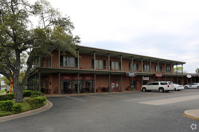
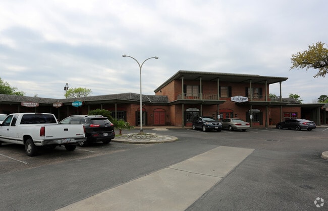
Property Record
3801 S Alameda St, Corpus Christi, TX 78411

Save to a Folder
{{folder.Name}}
{{folder.ListingIds.length}} Properties
{{folder.ListingIds.length}} Property
Create a New Folder
Property Detail
3801 S Alameda St
200051847
THE VILLAGE BK A
Commercialnec
NUECES
B1
Texas
B and X Area of moderate flood hazard, usually the area between the limits of the 100-year and 500-year floods.
1
2024
2.61 AC
2025
Mid-City
002500
Corpus Christi
33,562 SF
Corpus Christi, TX
NEARBY LISTINGS FOR SALE OR LEASE
DEMOGRAPHICS near 3801 S Alameda St
1 mile
3 mile
5 mile
2025 Total Population
11,849
89,937
194,968
2030 Population
11,626
88,459
192,475
Pop Growth 2025-2030
(1.88%)
(1.64%)
(1.28%)
Average Age
41
40
39
2025 Total Households
4,810
34,378
73,434
HH Growth 2025-2030
(1.93%)
(1.60%)
(1.34%)
Median Household Inc
$69,158
$57,190
$58,548
Avg Household Size
2.40
2.50
2.50
2025 Avg HH Vehicles
2.00
2.00
2.00
Median Home Value
$236,591
$165,643
$173,014
Median Year Built
1955
1960
1972
Nearby Places
Map Layers
Map Styles
 Street
 Aerial
Layers
 Traffic
 Biking
Places
Listings with unknown addresses are not visible on the map
- Restaurants
- Banks
- Shops
- Fitness
- Groceries
PUBLIC TRANSPORTATION
AIRPORT
Corpus Christi International
Drive
Walk
Distance
Corpus Christi International
19 min
11.3 mi
Freight Ports
Port of Corpus Christi
Drive
Walk
Distance
Port of Corpus Christi
8 min
4.9 mi
SALE & LEASE HISTORY
LISTING DATE
SALE/LEASE

Sep 08, 2017
For Lease
May 03, 2017
For Lease
Mar 10, 2017
For Lease
Jan 12, 2025
For Lease
Nearby Properties
Address
Land Use
TOTAL SIZE
Lot Size
Zoning
Address
Land Use
TOTAL SIZE
Lot Size
Zoning
567,638 SF
18.37 AC
B4
Address
Land Use
TOTAL SIZE
Lot Size
Zoning
674,927 SF
10.54 AC
B4
Address
Land Use
TOTAL SIZE
Lot Size
Zoning
747,956 SF
39.67 AC
B-4
Address
Land Use
TOTAL SIZE
Lot Size
Zoning
1 SF
62.73 AC
III
Address
Land Use
TOTAL SIZE
Lot Size
Zoning
176,076 SF
19.84 AC
R1B
Address
Land Use
TOTAL SIZE
Lot Size
Zoning
251,402 SF
7.17 AC
Address
Land Use
TOTAL SIZE
Lot Size
Zoning
117,000 SF
19.20 AC
R1B
Address
Land Use
TOTAL SIZE
Lot Size
Zoning
10,000 SF
35.96 AC
R1B
Address
Land Use
TOTAL SIZE
Lot Size
Zoning
245,114 SF
16.86 AC
Address
Land Use
TOTAL SIZE
Lot Size
Zoning
212,125 SF
16.55 AC
Address
Land Use
TOTAL SIZE
Lot Size
Zoning
104,851 SF
18.71 AC
R1B
Address
Land Use
TOTAL SIZE
Lot Size
Zoning
78,000 SF
6.92 AC
R1B
Address
Land Use
TOTAL SIZE
Lot Size
Zoning
1 SF
40.02 AC
R1B
Address
Land Use
TOTAL SIZE
Lot Size
Zoning
80,354 SF
7.11 AC
R1B
Address
Land Use
TOTAL SIZE
Lot Size
Zoning
65,301 SF
7.37 AC
B-4
Address
Land Use
TOTAL SIZE
Lot Size
Zoning
177,545 SF
7.75 AC
B2
Address
Land Use
TOTAL SIZE
Lot Size
Zoning
108,420 SF
20 AC
R1B
Address
Land Use
TOTAL SIZE
Lot Size
Zoning
13,773 SF
28.82 AC
R1B
Address
Land Use
TOTAL SIZE
Lot Size
Zoning
213,050 SF
34.44 AC
R1B
Address
Land Use
TOTAL SIZE
Lot Size
Zoning
114,121 SF
2.64 AC
B-4
Address
Land Use
TOTAL SIZE
Lot Size
Zoning
186,106 SF
6.54 AC
B1
Address
Land Use
TOTAL SIZE
Lot Size
Zoning
94,600 SF
9.29 AC
R2
Address
Land Use
TOTAL SIZE
Lot Size
Zoning
108,064 SF
6.09 AC
R1A
Address
Land Use
TOTAL SIZE
Lot Size
Zoning
192,450 SF
6.45 AC
Address
Land Use
TOTAL SIZE
Lot Size
Zoning
123,098 SF
2.39 AC
A2
Address
Land Use
TOTAL SIZE
Lot Size
Zoning
71,556 SF
4.11 AC
R1B
Address
Land Use
TOTAL SIZE
Lot Size
Zoning
60,934 SF
12.20 AC
R1B
Address
Land Use
TOTAL SIZE
Lot Size
Zoning
95,860 SF
10.80 AC
R1B
Address
Land Use
TOTAL SIZE
Lot Size
Zoning
73,559 SF
11.05 AC
R1B
Address
Land Use
TOTAL SIZE
Lot Size
Zoning
43,680 SF
1.37 AC
B4
The World's #1 Commercial Real Estate Marketplace
Connect with us
© 2026 CoStar Group
The information above has been obtained from sources believed reliable. While we do not doubt its accuracy we have not verified it and make no guarantee, warranty or representation about it. It is your responsibility to independently confirm its accuracy and completeness. Any projections, opinions, assumptions, or estimates used are for example only and do not represent the current or future performance of the property. The value of this transaction to you depends on tax and other factors which should be evaluated by your tax, financial, and legal advisors. You and your advisors should conduct a careful, independent investigation of the property to determine to your satisfaction the suitability of the property for your needs.