Property Record
382 N 1100 W, Payson, UT 84651

Save to a Folder
{{folder.Name}}
{{folder.ListingIds.length}} Properties
{{folder.ListingIds.length}} Property
Create a New Folder
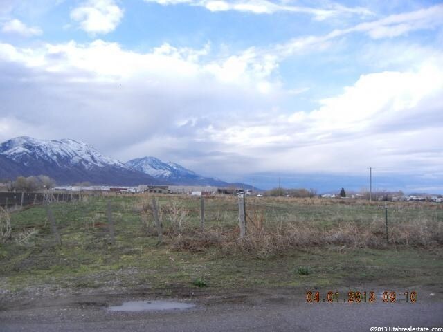
Property Detail
382 N 1100 W
Provo-Orem-Lehi, UT
PART LOT 1, PLAT A, HANKS SUB DESCRIBED AS FOLLOWS; COM S 3.2 FT & W 498.61 FT FR E 1/4 COR. SEC. 7, T9S, R2E, SLB&M.; S 0 DEG 9 17 W 301.85 FT; N 88 DEG 59 59 W 166.85 FT; N 2 DEG 50 34 E 281.95 FT; ALONG A CURVE TO R (CHORD BEARS: N 46 DEG 34 33 E
41-745-0005
Utah
Autorepair
Utah
2025
1
2026
1.10 AC
010504
Utah County
18,936 SF
Salt Lake City
NEARBY LISTINGS FOR SALE OR LEASE
DEMOGRAPHICS near 382 N 1100 W
1 mile
3 mile
5 mile
2025 Total Population
5,691
40,139
51,798
2030 Population
6,235
44,298
57,299
Pop Growth 2025-2030
+ 9.56%
+ 10.36%
+ 10.62%
Average Age
35
34
34
2025 Total Households
1,667
11,182
14,324
HH Growth 2025-2030
+ 10.26%
+ 11.07%
+ 11.34%
Median Household Inc
$90,219
$104,080
$106,440
Avg Household Size
3.40
3.60
3.60
2025 Avg HH Vehicles
2.00
3.00
3.00
Median Home Value
$466,133
$554,620
$585,613
Median Year Built
1990
2000
2001
Nearby Places
Map Layers
Map Styles
 Street
 Aerial
Layers
 Traffic
 Biking
Places
Listings with unknown addresses are not visible on the map
- Restaurants
- Banks
- Shops
- Fitness
- Groceries
PUBLIC TRANSPORTATION
AIRPORT
Provo Municipal
Drive
Walk
Distance
Provo Municipal
26 min
17.5 mi
SALE & LEASE HISTORY
LISTING DATE
SALE/LEASE

Nov 22, 2017
For Sale
Nearby Properties
Address
Land Use
TOTAL SIZE
Lot Size
Zoning
Address
Land Use
TOTAL SIZE
Lot Size
Zoning
182,965 SF
8.96 AC
Address
Land Use
TOTAL SIZE
Lot Size
Zoning
91,942 SF
13.34 AC
Address
Land Use
TOTAL SIZE
Lot Size
Zoning
356,234 SF
22.12 AC
Address
Land Use
TOTAL SIZE
Lot Size
Zoning
324,996 SF
23.15 AC
Address
Land Use
TOTAL SIZE
Lot Size
Zoning
332,095 SF
8.44 AC
Address
Land Use
TOTAL SIZE
Lot Size
Zoning
285,374 SF
10.98 AC
Address
Land Use
TOTAL SIZE
Lot Size
Zoning
184,314 SF
22.67 AC
Address
Land Use
TOTAL SIZE
Lot Size
Zoning
163,147 SF
8 AC
Address
Land Use
TOTAL SIZE
Lot Size
Zoning
64,375 SF
25.19 AC
Address
Land Use
TOTAL SIZE
Lot Size
Zoning
235,844 SF
6.57 AC
Address
Land Use
TOTAL SIZE
Lot Size
Zoning
185,917 SF
11.19 AC
Address
Land Use
TOTAL SIZE
Lot Size
Zoning
194,159 SF
14.47 AC
Address
Land Use
TOTAL SIZE
Lot Size
Zoning
95,684 SF
5.90 AC
Address
Land Use
TOTAL SIZE
Lot Size
Zoning
150,427 SF
44.48 AC
RA5
Address
Land Use
TOTAL SIZE
Lot Size
Zoning
95,684 SF
6.14 AC
Address
Land Use
TOTAL SIZE
Lot Size
Zoning
107,284 SF
Address
Land Use
TOTAL SIZE
Lot Size
Zoning
99,114 SF
3.67 AC
Address
Land Use
TOTAL SIZE
Lot Size
Zoning
122,808 SF
6.61 AC
Address
Land Use
TOTAL SIZE
Lot Size
Zoning
32,028 SF
5 AC
Address
Land Use
TOTAL SIZE
Lot Size
Zoning
125,459 SF
10 AC
Address
Land Use
TOTAL SIZE
Lot Size
Zoning
95,818 SF
4.04 AC
Address
Land Use
TOTAL SIZE
Lot Size
Zoning
47,405 SF
3.96 AC
Address
Land Use
TOTAL SIZE
Lot Size
Zoning
39,168 SF
3.54 AC
Address
Land Use
TOTAL SIZE
Lot Size
Zoning
81,217 SF
5.74 AC
Address
Land Use
TOTAL SIZE
Lot Size
Zoning
58,152 SF
1.47 AC
Address
Land Use
TOTAL SIZE
Lot Size
Zoning
54,940 SF
3.08 AC
Address
Land Use
TOTAL SIZE
Lot Size
Zoning
35,180 SF
2 AC
Address
Land Use
TOTAL SIZE
Lot Size
Zoning
51,755 SF
4.76 AC
Address
Land Use
TOTAL SIZE
Lot Size
Zoning
90,004 SF
5.64 AC
The World's #1 Commercial Real Estate Marketplace
Connect with us
© 2026 CoStar Group
The information above has been obtained from sources believed reliable. While we do not doubt its accuracy we have not verified it and make no guarantee, warranty or representation about it. It is your responsibility to independently confirm its accuracy and completeness. Any projections, opinions, assumptions, or estimates used are for example only and do not represent the current or future performance of the property. The value of this transaction to you depends on tax and other factors which should be evaluated by your tax, financial, and legal advisors. You and your advisors should conduct a careful, independent investigation of the property to determine to your satisfaction the suitability of the property for your needs.