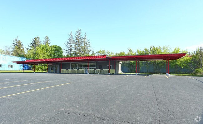
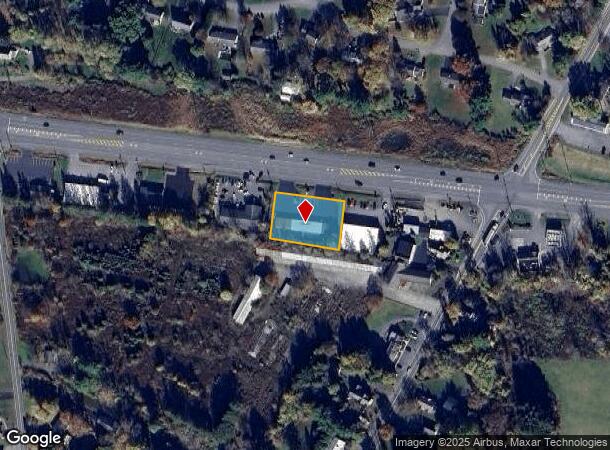
Property Record
384 Quaker Rd, Queensbury, NY 12804
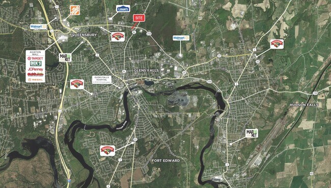

NEARBY LISTINGS FOR SALE OR LEASE
Property Detail
384 Quaker Rd
Glens Falls, NY
JIMMY'S RESTAURANT 200'RF 59.-5-5
523400-303-005-0001-083-000-0000
Warren
Restaurantbuilding
New York
2025
83.000
2024
0.62 AC
070701
Warren County
1,608 SF
Albany/Schenectady/Troy
DEMOGRAPHICS near 384 Quaker Rd
1 Mile
3 Mile
5 Mile
2024 Total Population
4,229
34,399
64,622
2029 Population
4,136
34,056
64,095
Pop Growth 2024-2029
(2.20%)
(1.00%)
(0.82%)
Average Age
43
43
43
2024 Total Households
1,948
15,686
27,953
HH Growth 2024-2029
(2.26%)
(0.99%)
(0.84%)
Median Household Inc
$59,881
$64,514
$70,366
Avg Household Size
2.00
2.10
2.20
2024 Avg HH Vehicles
2.00
2.00
2.00
Median Home Value
$182,745
$192,228
$201,536
Median Year Built
1950
1968
1972
Nearby Places
- Restaurants
- Banks
- Shops
- Fitness
- Groceries
PUBLIC TRANSPORTATION
COMMUTER RAIL
Fort Edward Amtrak (Adirondack - Amtrak, Ethan Allen Express - Amtrak)
DRIVE
WALK
Distance
Fort Edward Amtrak (Adirondack - Amtrak, Ethan Allen Express - Amtrak)
14 min
6.2 mi
Freight Ports
Albany, NY Port
DRIVE
WALK
Distance
Albany, NY Port
74 min
57.0 mi
SALE & LEASE HISTORY
LISTING DATE
SALE/LEASE

May 18, 2017
For Lease
May 18, 2017
For Sale
Jul 06, 2023
For Sale
Nearby Properties
Address
Land Use
TOTAL SIZE
Lot Size
Zoning
Address
Land Use
TOTAL SIZE
Lot Size
Zoning
273,242 SF
11.07 AC
GC2
Address
Land Use
TOTAL SIZE
Lot Size
Zoning
27,660 SF
130.13 AC
O
Address
Land Use
TOTAL SIZE
Lot Size
Zoning
16.34 AC
M1
Address
Land Use
TOTAL SIZE
Lot Size
Zoning
35.53 AC
HI
Address
Land Use
TOTAL SIZE
Lot Size
Zoning
161,338 SF
1.74 AC
GC2
Address
Land Use
TOTAL SIZE
Lot Size
Zoning
154,236 SF
104.60 AC
RR-3A
Address
Land Use
TOTAL SIZE
Lot Size
Zoning
19.74 AC
HI
Address
Land Use
TOTAL SIZE
Lot Size
Zoning
Address
Land Use
TOTAL SIZE
Lot Size
Zoning
9,216 SF
32.20 AC
UR
Address
Land Use
TOTAL SIZE
Lot Size
Zoning
116,357 SF
34.05 AC
PUD
Address
Land Use
TOTAL SIZE
Lot Size
Zoning
191,130 SF
20.09 AC
R-1A
Address
Land Use
TOTAL SIZE
Lot Size
Zoning
82,922 SF
8.03 AC
I
Address
Land Use
TOTAL SIZE
Lot Size
Zoning
6,112 SF
28.50 AC
O
Address
Land Use
TOTAL SIZE
Lot Size
Zoning
Address
Land Use
TOTAL SIZE
Lot Size
Zoning
29,108 SF
22.48 AC
MDR
Address
Land Use
TOTAL SIZE
Lot Size
Zoning
1.91 AC
HI
Address
Land Use
TOTAL SIZE
Lot Size
Zoning
183,950 SF
11.41 AC
C1
Address
Land Use
TOTAL SIZE
Lot Size
Zoning
27,470 SF
14.76 AC
MDR
Address
Land Use
TOTAL SIZE
Lot Size
Zoning
31,456 SF
15.49 AC
MDR
Address
Land Use
TOTAL SIZE
Lot Size
Zoning
91,000 SF
0.52 AC
GC2
Address
Land Use
TOTAL SIZE
Lot Size
Zoning
5,440 SF
510.06 AC
CLI
Address
Land Use
TOTAL SIZE
Lot Size
Zoning
9.72 AC
CI
Address
Land Use
TOTAL SIZE
Lot Size
Zoning
12,337 SF
26.95 AC
HI
Address
Land Use
TOTAL SIZE
Lot Size
Zoning
215,447 SF
17.74 AC
CI
Address
Land Use
TOTAL SIZE
Lot Size
Zoning
130,142 SF
20.71 AC
CI
Address
Land Use
TOTAL SIZE
Lot Size
Zoning
70,176 SF
3.50 AC
GC1
Address
Land Use
TOTAL SIZE
Lot Size
Zoning
7,823 SF
27.33 AC
LDR25
Address
Land Use
TOTAL SIZE
Lot Size
Zoning
8,042 SF
39.64 AC
O
Address
Land Use
TOTAL SIZE
Lot Size
Zoning
6,549 SF
17.26 AC
M1
Address
Land Use
TOTAL SIZE
Lot Size
Zoning
The World's #1 Commercial Real Estate Marketplace
Connect with us
© 2025 CoStar Group
The information above has been obtained from sources believed reliable. While we do not doubt its accuracy we have not verified it and make no guarantee, warranty or representation about it. It is your responsibility to independently confirm its accuracy and completeness. Any projections, opinions, assumptions, or estimates used are for example only and do not represent the current or future performance of the property. The value of this transaction to you depends on tax and other factors which should be evaluated by your tax, financial, and legal advisors. You and your advisors should conduct a careful, independent investigation of the property to determine to your satisfaction the suitability of the property for your needs.