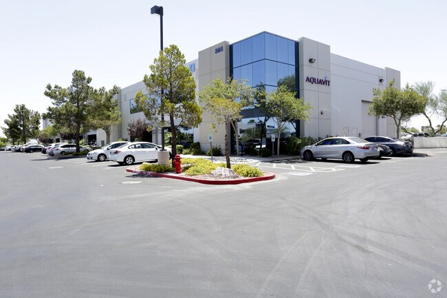
Property Record
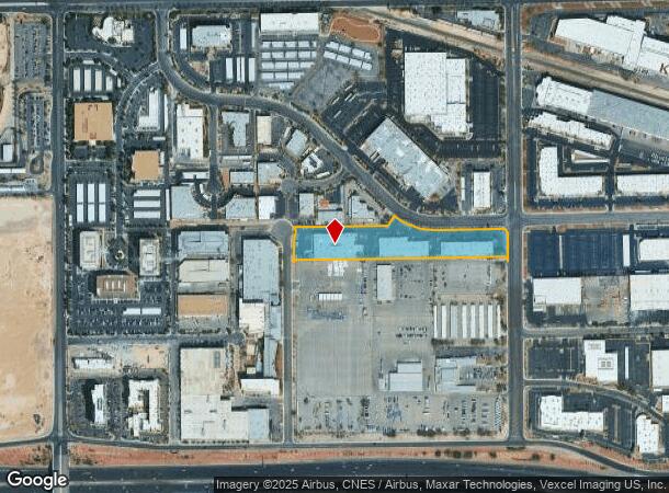
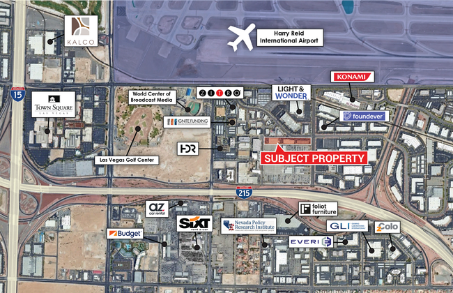
385 Pilot Rd, Las Vegas, NV 89119
NEARBY LISTINGS FOR SALE OR LEASE
-
-
-
-
-
-
-
-
W. Sunset Rd. & South Decatur Blvd
Las Vegas, NV 89118
Rent Upon Request
4,378 - 43,468 SF
Industrial
-
View all Las Vegas listings for lease on LoopNet.com
Property Detail
385 Pilot Rd
Las Vegas-Henderson-North Las Vegas, NV
Dm Airport Center
177-04-612-001
DM AIRPORT CENTER PLAT BOOK 147 PAGE 13 LOT 1
Commercialnec
Clark
X
Nevada
32003C2560F
1
2026
5.11 AC
2026
Airport/E Las Vegas
002847
Las Vegas
79,914 SF
DEMOGRAPHICS near 385 Pilot Rd
1 mile
3 mile
5 mile
2024 Total Population
1,693
73,751
362,592
2029 Population
1,799
79,084
389,731
Pop Growth 2024-2029
+ 6.26%
+ 7.23%
+ 7.48%
Average Age
42
41
40
2024 Total Households
656
31,240
151,593
HH Growth 2024-2029
+ 6.10%
+ 7.30%
+ 7.50%
Median Household Inc
$73,778
$58,520
$58,366
Avg Household Size
2.40
2.30
2.30
2024 Avg HH Vehicles
2.00
2.00
2.00
Median Home Value
$432,417
$384,964
$370,960
Median Year Built
1989
1992
1993
Nearby Places
Map Layers
Map Styles
 Street
 Aerial
Transit
 Traffic
 Biking
Places
Listings with unknown addresses are not visible on the map
- Restaurants
- Banks
- Shops
- Fitness
- Groceries
PUBLIC TRANSPORTATION
AIRPORT
Harry Reid International
Drive
Walk
Distance
Harry Reid International
8 min
3.4 mi
Boulder City Municipal
Drive
Walk
Distance
Boulder City Municipal
34 min
23.4 mi
SALE & LEASE HISTORY
LISTING DATE
SALE/LEASE

Sep 24, 2024
For Lease
Nov 06, 2018
For Lease
Mar 03, 2020
For Lease
Jun 24, 2025
For Lease
Feb 06, 2023
For Lease
Nearby Properties
Address
Land Use
TOTAL SIZE
Lot Size
Zoning
Address
Land Use
TOTAL SIZE
Lot Size
Zoning
2,000,377 SF
118.89 AC
Address
Land Use
TOTAL SIZE
Lot Size
Zoning
1,546,466 SF
61.43 AC
H1
Address
Land Use
TOTAL SIZE
Lot Size
Zoning
2,828,726 SF
101.88 AC
Address
Land Use
TOTAL SIZE
Lot Size
Zoning
937,376 SF
59.19 AC
Address
Land Use
TOTAL SIZE
Lot Size
Zoning
1,166,098 SF
57.58 AC
Address
Land Use
TOTAL SIZE
Lot Size
Zoning
225,512 SF
50.14 AC
Address
Land Use
TOTAL SIZE
Lot Size
Zoning
112,160 SF
20.60 AC
Address
Land Use
TOTAL SIZE
Lot Size
Zoning
742,547 SF
19.87 AC
H1
Address
Land Use
TOTAL SIZE
Lot Size
Zoning
79.03 AC
PF
Address
Land Use
TOTAL SIZE
Lot Size
Zoning
3,200 SF
16.74 AC
Address
Land Use
TOTAL SIZE
Lot Size
Zoning
764,918 SF
94.41 AC
H1
Address
Land Use
TOTAL SIZE
Lot Size
Zoning
323,696 SF
24.62 AC
H1
Address
Land Use
TOTAL SIZE
Lot Size
Zoning
76.93 AC
PF
Address
Land Use
TOTAL SIZE
Lot Size
Zoning
278,297 SF
35.11 AC
Address
Land Use
TOTAL SIZE
Lot Size
Zoning
62,927 SF
1.83 AC
Address
Land Use
TOTAL SIZE
Lot Size
Zoning
138.07 AC
PF
Address
Land Use
TOTAL SIZE
Lot Size
Zoning
17,406 SF
9.46 AC
Address
Land Use
TOTAL SIZE
Lot Size
Zoning
611,977 SF
6.82 AC
Address
Land Use
TOTAL SIZE
Lot Size
Zoning
94,198 SF
34.53 AC
H1
Address
Land Use
TOTAL SIZE
Lot Size
Zoning
32,655 SF
2.40 AC
Address
Land Use
TOTAL SIZE
Lot Size
Zoning
949,035 SF
2.21 AC
C:H-1
Address
Land Use
TOTAL SIZE
Lot Size
Zoning
321,990 SF
76.15 AC
PF
Address
Land Use
TOTAL SIZE
Lot Size
Zoning
391,021 SF
40.14 AC
Address
Land Use
TOTAL SIZE
Lot Size
Zoning
56.95 AC
PF
Address
Land Use
TOTAL SIZE
Lot Size
Zoning
13.26 AC
Address
Land Use
TOTAL SIZE
Lot Size
Zoning
459,983 SF
12.65 AC
M1
Address
Land Use
TOTAL SIZE
Lot Size
Zoning
101,961 SF
15.42 AC
H1
Address
Land Use
TOTAL SIZE
Lot Size
Zoning
66.26 AC
RE
Address
Land Use
TOTAL SIZE
Lot Size
Zoning
527,044 SF
1.08 AC
H1
Address
Land Use
TOTAL SIZE
Lot Size
Zoning
353,690 SF
17.23 AC
The World's #1 Commercial Real Estate Marketplace
Connect with us
© 2026 CoStar Group
The information above has been obtained from sources believed reliable. While we do not doubt its accuracy we have not verified it and make no guarantee, warranty or representation about it. It is your responsibility to independently confirm its accuracy and completeness. Any projections, opinions, assumptions, or estimates used are for example only and do not represent the current or future performance of the property. The value of this transaction to you depends on tax and other factors which should be evaluated by your tax, financial, and legal advisors. You and your advisors should conduct a careful, independent investigation of the property to determine to your satisfaction the suitability of the property for your needs.