Property Record
3850 Highway 138 Sw, Stockbridge, GA 30281
NEARBY LISTINGS FOR SALE OR LEASE
Property Detail
3850 Highway 138 Sw
Atlanta-Sandy Springs-Roswell, GA
Rural
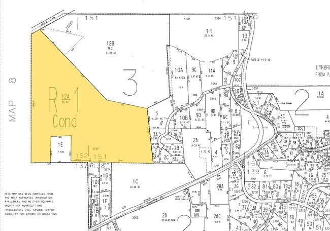
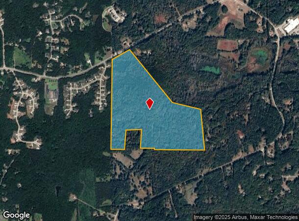
015-0-03-012A
&LL152 S/SIDE HWY 138
Privatepreserveopenspacevacantlandforestlandconservation
Rockdale
A
Georgia
13247C0153D
95 AC
2024
I-20 East/Conyers
2025
Atlanta
070113
DEMOGRAPHICS near 3850 Highway 138 Sw
1 Mile
3 Mile
5 Mile
2024 Total Population
1,027
11,329
45,058
2029 Population
1,061
11,600
46,882
Pop Growth 2024-2029
+ 3.31%
+ 2.39%
+ 4.05%
Average Age
44
41
41
2024 Total Households
365
3,947
15,597
HH Growth 2024-2029
+ 3.56%
+ 2.38%
+ 4.02%
Median Household Inc
$81,731
$70,847
$76,464
Avg Household Size
2.80
2.80
2.80
2024 Avg HH Vehicles
3.00
2.00
2.00
Median Home Value
$275,262
$244,408
$250,589
Median Year Built
1993
1998
1995
Nearby Places
Map Layers
Map Styles
 Street
 Aerial
- Restaurants
- Banks
- Shops
- Fitness
- Groceries
PUBLIC TRANSPORTATION
AIRPORT
Hartsfield - Jackson Atlanta International
DRIVE
WALK
Distance
Hartsfield - Jackson Atlanta International
38 min
24.9 mi
Freight Ports
Georgia Ports - Savannah
DRIVE
WALK
Distance
Georgia Ports - Savannah
266 min
234.2 mi
Nearby Properties
Address
Land Use
TOTAL SIZE
Lot Size
Zoning
Address
Land Use
TOTAL SIZE
Lot Size
Zoning
88,314 SF
107.40 AC
AR
Address
Land Use
TOTAL SIZE
Lot Size
Zoning
69,417 SF
13.85 AC
C1/C
Address
Land Use
TOTAL SIZE
Lot Size
Zoning
113,548 SF
15 AC
AR
Address
Land Use
TOTAL SIZE
Lot Size
Zoning
82,000 SF
23.58 AC
AR
Address
Land Use
TOTAL SIZE
Lot Size
Zoning
48,048 SF
8.46 AC
C2
Address
Land Use
TOTAL SIZE
Lot Size
Zoning
26,050 SF
37.18 AC
RA
Address
Land Use
TOTAL SIZE
Lot Size
Zoning
139,260 SF
13.93 AC
Address
Land Use
TOTAL SIZE
Lot Size
Zoning
489.57 AC
AR
Address
Land Use
TOTAL SIZE
Lot Size
Zoning
560.20 AC
AR
Address
Land Use
TOTAL SIZE
Lot Size
Zoning
113.51 AC
AR/R1/C
Address
Land Use
TOTAL SIZE
Lot Size
Zoning
21,840 SF
15 AC
AR
Address
Land Use
TOTAL SIZE
Lot Size
Zoning
3,621 SF
1.25 AC
C1
Address
Land Use
TOTAL SIZE
Lot Size
Zoning
2,978 SF
1.03 AC
C1
Address
Land Use
TOTAL SIZE
Lot Size
Zoning
15,400 SF
13.35 AC
AR
Address
Land Use
TOTAL SIZE
Lot Size
Zoning
9,421 SF
3.18 AC
AR/C1
Address
Land Use
TOTAL SIZE
Lot Size
Zoning
5,670 SF
2.49 AC
OI/COND
Address
Land Use
TOTAL SIZE
Lot Size
Zoning
4,140 SF
2.04 AC
C1
Address
Land Use
TOTAL SIZE
Lot Size
Zoning
9,600 SF
0.65 AC
OI
Address
Land Use
TOTAL SIZE
Lot Size
Zoning
13,960 SF
3.04 AC
OI/C
Address
Land Use
TOTAL SIZE
Lot Size
Zoning
175.80 AC
AR
Address
Land Use
TOTAL SIZE
Lot Size
Zoning
11,803 SF
2.06 AC
C1
Address
Land Use
TOTAL SIZE
Lot Size
Zoning
275 AC
AR
Address
Land Use
TOTAL SIZE
Lot Size
Zoning
392.41 AC
R85
Address
Land Use
TOTAL SIZE
Lot Size
Zoning
6,000 SF
1.30 AC
C3
Address
Land Use
TOTAL SIZE
Lot Size
Zoning
5,000 SF
1.65 AC
C1
Address
Land Use
TOTAL SIZE
Lot Size
Zoning
13,500 SF
2.03 AC
C1
Address
Land Use
TOTAL SIZE
Lot Size
Zoning
3,956 SF
0.91 AC
C1
Address
Land Use
TOTAL SIZE
Lot Size
Zoning
928 SF
126.54 AC
RA
Address
Land Use
TOTAL SIZE
Lot Size
Zoning
146.05 AC
AR
Address
Land Use
TOTAL SIZE
Lot Size
Zoning
49.97 AC
R1
The World's #1 Commercial Real Estate Marketplace
Connect with us
© 2026 CoStar Group
The information above has been obtained from sources believed reliable. While we do not doubt its accuracy we have not verified it and make no guarantee, warranty or representation about it. It is your responsibility to independently confirm its accuracy and completeness. Any projections, opinions, assumptions, or estimates used are for example only and do not represent the current or future performance of the property. The value of this transaction to you depends on tax and other factors which should be evaluated by your tax, financial, and legal advisors. You and your advisors should conduct a careful, independent investigation of the property to determine to your satisfaction the suitability of the property for your needs.