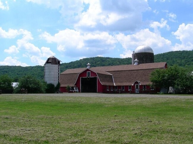
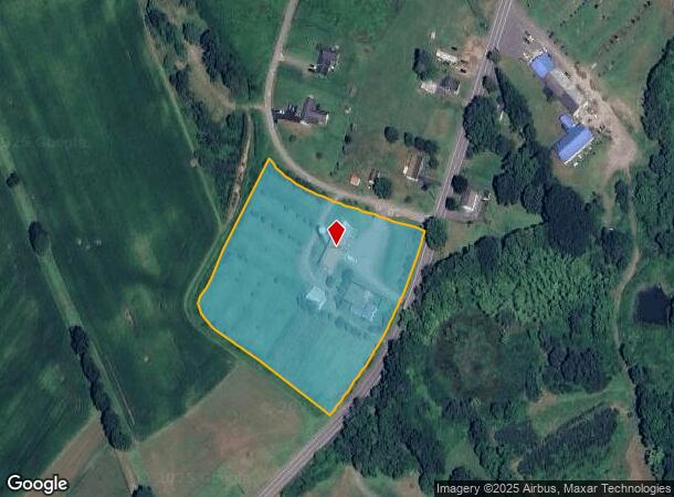
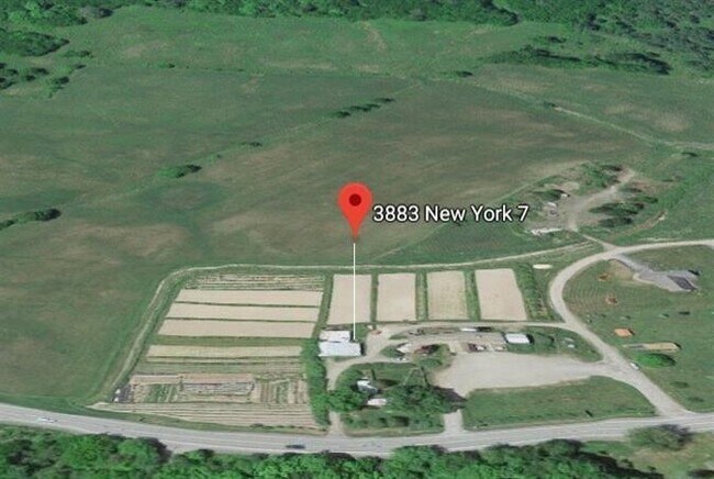
Property Record
3883 State Highway 7, Otego, NY 13825
NEARBY LISTINGS FOR SALE OR LEASE
Property Detail
3883 State Highway 7
364889-308-000-0001-050-000-0000
998FM 2518 0 0
Orchard
Otsego
X
New York
36077C0642E
50.000
2025
5.18 AC
2024
Otsego County
591401
Albany/Schenectady/Troy
4,904 SF
Oneonta, NY
DEMOGRAPHICS near 3883 State Highway 7
1 Mile
3 Mile
5 Mile
2024 Total Population
341
2,477
14,984
2029 Population
343
2,432
14,893
Pop Growth 2024-2029
+ 0.59%
(1.82%)
(0.61%)
Average Age
46
47
38
2024 Total Households
149
1,044
4,739
HH Growth 2024-2029
+ 0.67%
(2.11%)
(0.74%)
Median Household Inc
$60,500
$58,308
$55,230
Avg Household Size
2.20
2.20
2.10
2024 Avg HH Vehicles
2.00
2.00
2.00
Median Home Value
$179,786
$166,301
$172,723
Median Year Built
1975
1967
1953
Nearby Places
Map Layers
Map Styles
 Street
 Aerial
- Restaurants
- Banks
- Shops
- Fitness
- Groceries
SALE & LEASE HISTORY
LISTING DATE
SALE/LEASE

Feb 02, 2021
For Sale
Nearby Properties
Address
Land Use
TOTAL SIZE
Lot Size
Zoning
Address
Land Use
TOTAL SIZE
Lot Size
Zoning
8,400 SF
65.53 AC
510
Address
Land Use
TOTAL SIZE
Lot Size
Zoning
6,272 SF
14.45 AC
Address
Land Use
TOTAL SIZE
Lot Size
Zoning
960 SF
13.66 AC
Address
Land Use
TOTAL SIZE
Lot Size
Zoning
42,492 SF
11.21 AC
01
Address
Land Use
TOTAL SIZE
Lot Size
Zoning
77,280 SF
14.94 AC
01
Address
Land Use
TOTAL SIZE
Lot Size
Zoning
720 SF
13.67 AC
01
Address
Land Use
TOTAL SIZE
Lot Size
Zoning
9,540 SF
8.31 AC
Address
Land Use
TOTAL SIZE
Lot Size
Zoning
15,172 SF
4.52 AC
R2
Address
Land Use
TOTAL SIZE
Lot Size
Zoning
47,320 SF
4.63 AC
01
Address
Land Use
TOTAL SIZE
Lot Size
Zoning
17.92 AC
Address
Land Use
TOTAL SIZE
Lot Size
Zoning
36,000 SF
3.85 AC
510
Address
Land Use
TOTAL SIZE
Lot Size
Zoning
784 SF
19.04 AC
R3
Address
Land Use
TOTAL SIZE
Lot Size
Zoning
43.81 AC
Address
Land Use
TOTAL SIZE
Lot Size
Zoning
240 SF
6.11 AC
Address
Land Use
TOTAL SIZE
Lot Size
Zoning
25,908 SF
10.67 AC
01
Address
Land Use
TOTAL SIZE
Lot Size
Zoning
3,500 SF
36.35 AC
Address
Land Use
TOTAL SIZE
Lot Size
Zoning
4,020 SF
1.85 AC
Address
Land Use
TOTAL SIZE
Lot Size
Zoning
14,400 SF
3.85 AC
510
Address
Land Use
TOTAL SIZE
Lot Size
Zoning
19,200 SF
3.92 AC
01
Address
Land Use
TOTAL SIZE
Lot Size
Zoning
13.14 AC
Address
Land Use
TOTAL SIZE
Lot Size
Zoning
26,000 SF
1.44 AC
01
Address
Land Use
TOTAL SIZE
Lot Size
Zoning
20,000 SF
2.84 AC
01
Address
Land Use
TOTAL SIZE
Lot Size
Zoning
4,634 SF
0.49 AC
R2
Address
Land Use
TOTAL SIZE
Lot Size
Zoning
10,800 SF
3.18 AC
Address
Land Use
TOTAL SIZE
Lot Size
Zoning
6,000 SF
21.28 AC
R3
Address
Land Use
TOTAL SIZE
Lot Size
Zoning
1,880 SF
4.43 AC
01
Address
Land Use
TOTAL SIZE
Lot Size
Zoning
4,036 SF
0.57 AC
Address
Land Use
TOTAL SIZE
Lot Size
Zoning
4,144 SF
5.99 AC
510
Address
Land Use
TOTAL SIZE
Lot Size
Zoning
8,020 SF
1.86 AC
Address
Land Use
TOTAL SIZE
Lot Size
Zoning
21.65 AC
01
The World's #1 Commercial Real Estate Marketplace
Connect with us
© 2025 CoStar Group
The information above has been obtained from sources believed reliable. While we do not doubt its accuracy we have not verified it and make no guarantee, warranty or representation about it. It is your responsibility to independently confirm its accuracy and completeness. Any projections, opinions, assumptions, or estimates used are for example only and do not represent the current or future performance of the property. The value of this transaction to you depends on tax and other factors which should be evaluated by your tax, financial, and legal advisors. You and your advisors should conduct a careful, independent investigation of the property to determine to your satisfaction the suitability of the property for your needs.