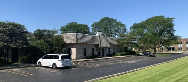
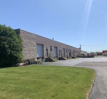
Property Record
390 E Saint Charles Rd, Lombard, IL 60148

Current Lease Availabilities
Property Detail
390 E Saint Charles Rd
06-05-322-008
HERBRECHTS SUB /EX PT LYG NELY OF LN DRWN FROM SE CORNER TO A PT ON N/LN 30.05 FT W OF NE COR/
Industrialgeneral
DuPage
I
Illinois
B and X Area of moderate flood hazard, usually the area between the limits of the 100-year and 500-year floods.
4
2024
0.31 AC
2024
North DuPage
843500
Chicago
3,750 SF
Chicago-Naperville-Elgin, IL-IN
NEARBY LISTINGS FOR SALE OR LEASE
DEMOGRAPHICS near 390 E Saint Charles Rd
1 mile
3 mile
5 mile
2025 Total Population
10,198
114,681
254,070
2030 Population
10,277
115,537
255,915
Pop Growth 2025-2030
+ 0.77%
+ 0.75%
+ 0.73%
Average Age
37
40
41
2025 Total Households
4,012
40,191
91,724
HH Growth 2025-2030
+ 0.82%
+ 0.82%
+ 0.74%
Median Household Inc
$82,354
$106,961
$109,563
Avg Household Size
2.50
2.70
2.70
2025 Avg HH Vehicles
2.00
2.00
2.00
Median Home Value
$319,371
$356,301
$368,891
Median Year Built
1979
1975
1977
Nearby Places
Map Layers
Map Styles
 Street
 Aerial
Layers
 Traffic
 Biking
Places
Listings with unknown addresses are not visible on the map
- Restaurants
- Banks
- Shops
- Fitness
- Groceries
PUBLIC TRANSPORTATION
COMMUTER RAIL
Lombard Station (Union Pacific West Line - Northeast Illinois Regional Commuter Railroad (Metra))
Drive
Walk
Distance
Lombard Station (Union Pacific West Line - Northeast Illinois Regional Commuter Railroad (Metra))
1 min
11 min
0.5 mi
Villa Park Station (Union Pacific West Line - Northeast Illinois Regional Commuter Railroad (Metra))
Drive
Walk
Distance
Villa Park Station (Union Pacific West Line - Northeast Illinois Regional Commuter Railroad (Metra))
5 min
2.2 mi
AIRPORT
Chicago O'Hare International
Drive
Walk
Distance
Chicago O'Hare International
36 min
13.2 mi
Chicago Midway International
Drive
Walk
Distance
Chicago Midway International
39 min
20.3 mi
Nearby Properties
Address
Land Use
TOTAL SIZE
Lot Size
Zoning
Address
Land Use
TOTAL SIZE
Lot Size
Zoning
834,293 SF
40.24 AC
M
Address
Land Use
TOTAL SIZE
Lot Size
Zoning
312,131 SF
13.66 AC
M
Address
Land Use
TOTAL SIZE
Lot Size
Zoning
12.21 AC
Address
Land Use
TOTAL SIZE
Lot Size
Zoning
338,664 SF
11.42 AC
M
Address
Land Use
TOTAL SIZE
Lot Size
Zoning
271,822 SF
26.29 AC
Address
Land Use
TOTAL SIZE
Lot Size
Zoning
204,600 SF
9.45 AC
M
Address
Land Use
TOTAL SIZE
Lot Size
Zoning
102,314 SF
4.16 AC
R
Address
Land Use
TOTAL SIZE
Lot Size
Zoning
459,796 SF
18.15 AC
I
Address
Land Use
TOTAL SIZE
Lot Size
Zoning
220,900 SF
11.48 AC
M
Address
Land Use
TOTAL SIZE
Lot Size
Zoning
135,355 SF
12.12 AC
C
Address
Land Use
TOTAL SIZE
Lot Size
Zoning
309,864 SF
37.33 AC
I
Address
Land Use
TOTAL SIZE
Lot Size
Zoning
453,152 SF
20.35 AC
I
Address
Land Use
TOTAL SIZE
Lot Size
Zoning
287,909 SF
20.54 AC
Address
Land Use
TOTAL SIZE
Lot Size
Zoning
10.60 AC
Address
Land Use
TOTAL SIZE
Lot Size
Zoning
205,000 SF
16.78 AC
I
Address
Land Use
TOTAL SIZE
Lot Size
Zoning
190,719 SF
10.10 AC
Address
Land Use
TOTAL SIZE
Lot Size
Zoning
175,260 SF
1.36 AC
R
Address
Land Use
TOTAL SIZE
Lot Size
Zoning
139,672 SF
15.41 AC
I
Address
Land Use
TOTAL SIZE
Lot Size
Zoning
144,800 SF
8.41 AC
Address
Land Use
TOTAL SIZE
Lot Size
Zoning
147,134 SF
9.60 AC
M
Address
Land Use
TOTAL SIZE
Lot Size
Zoning
354,115 SF
24.95 AC
C
Address
Land Use
TOTAL SIZE
Lot Size
Zoning
203,058 SF
25.91 AC
C
Address
Land Use
TOTAL SIZE
Lot Size
Zoning
237,520 SF
9.98 AC
I
Address
Land Use
TOTAL SIZE
Lot Size
Zoning
254,880 SF
12.59 AC
M
Address
Land Use
TOTAL SIZE
Lot Size
Zoning
7.16 AC
I
Address
Land Use
TOTAL SIZE
Lot Size
Zoning
183,257 SF
12.66 AC
Address
Land Use
TOTAL SIZE
Lot Size
Zoning
258,333 SF
14.30 AC
I
Address
Land Use
TOTAL SIZE
Lot Size
Zoning
74,394 SF
8.57 AC
Address
Land Use
TOTAL SIZE
Lot Size
Zoning
205,926 SF
8.06 AC
I
Address
Land Use
TOTAL SIZE
Lot Size
Zoning
8.03 AC
The World's #1 Commercial Real Estate Marketplace
Connect with us
© 2026 CoStar Group
The information above has been obtained from sources believed reliable. While we do not doubt its accuracy we have not verified it and make no guarantee, warranty or representation about it. It is your responsibility to independently confirm its accuracy and completeness. Any projections, opinions, assumptions, or estimates used are for example only and do not represent the current or future performance of the property. The value of this transaction to you depends on tax and other factors which should be evaluated by your tax, financial, and legal advisors. You and your advisors should conduct a careful, independent investigation of the property to determine to your satisfaction the suitability of the property for your needs.