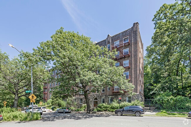
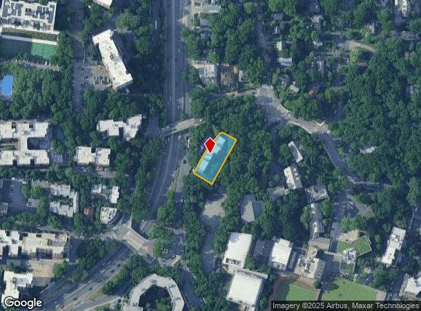
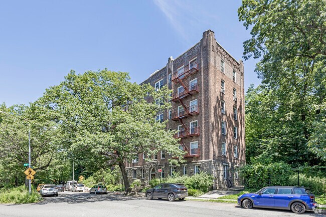
Property Record
3900 Henry Hudson Pkwy, Bronx, NY 10471
NEARBY LISTINGS FOR SALE OR LEASE
Property Detail
3900 Henry Hudson Pkwy
05781-1100
Bronx
Apartment
New York
X
1100
34003C0220H
0.50 AC
2024
Fieldston
2025
Westchester/So Connecticut
033700
New York-Jersey City-White Plains, NY-NJ
37,962 SF
DEMOGRAPHICS near 3900 Henry Hudson Pkwy
1 Mile
3 Mile
5 Mile
2024 Total Population
68,468
659,255
1,713,963
2029 Population
65,113
618,480
1,607,605
Pop Growth 2024-2029
(4.90%)
(6.19%)
(6.21%)
Average Age
43
39
39
2024 Total Households
28,430
239,278
624,395
HH Growth 2024-2029
(5.49%)
(6.77%)
(6.65%)
Median Household Inc
$77,265
$49,041
$50,051
Avg Household Size
2.20
2.60
2.60
2024 Avg HH Vehicles
1.00
1.00
1.00
Median Home Value
$397,569
$489,314
$476,520
Median Year Built
1956
1948
1951
Nearby Places
- Restaurants
- Banks
- Shops
- Fitness
- Groceries
PUBLIC TRANSPORTATION
TRANSIT/SUBWAY
238 Street (1 - New York MTA Subway (The Subway))
DRIVE
WALK
Distance
238 Street (1 - New York MTA Subway (The Subway))
3 min
11 min
0.6 mi
Van Cortlandt Park-242 Street (1 - New York MTA Subway (The Subway))
DRIVE
WALK
Distance
Van Cortlandt Park-242 Street (1 - New York MTA Subway (The Subway))
3 min
13 min
0.7 mi
231 Street (1 - New York MTA Subway (The Subway))
DRIVE
WALK
Distance
231 Street (1 - New York MTA Subway (The Subway))
3 min
18 min
1.0 mi
COMMUTER RAIL
Riverdale Station (Hudson Line - Metro-North Commuter Railroad Company (Metro-North))
DRIVE
WALK
Distance
Riverdale Station (Hudson Line - Metro-North Commuter Railroad Company (Metro-North))
3 min
1.4 mi
Spuyten Duyvil Station (Hudson Line - Metro-North Commuter Railroad Company (Metro-North))
DRIVE
WALK
Distance
Spuyten Duyvil Station (Hudson Line - Metro-North Commuter Railroad Company (Metro-North))
4 min
1.5 mi
AIRPORT
LaGuardia
DRIVE
WALK
Distance
LaGuardia
23 min
12.6 mi
John F Kennedy International
DRIVE
WALK
Distance
John F Kennedy International
36 min
23.8 mi
Westchester County
DRIVE
WALK
Distance
Westchester County
33 min
24.8 mi
Freight Ports
NY - Red Hook Container Terminal
DRIVE
WALK
Distance
NY - Red Hook Container Terminal
35 min
20.8 mi
Nearby Properties
Address
Land Use
TOTAL SIZE
Lot Size
Zoning
Address
Land Use
TOTAL SIZE
Lot Size
Zoning
1,299,700 SF
29.82 AC
R6
Address
Land Use
TOTAL SIZE
Lot Size
Zoning
1,743,584 SF
77.87 AC
R6
Address
Land Use
TOTAL SIZE
Lot Size
Zoning
111.37 AC
P1
Address
Land Use
TOTAL SIZE
Lot Size
Zoning
24.08 AC
B2-A
Address
Land Use
TOTAL SIZE
Lot Size
Zoning
72 AC
P1
Address
Land Use
TOTAL SIZE
Lot Size
Zoning
481,172 SF
205.58 AC
PARK
Address
Land Use
TOTAL SIZE
Lot Size
Zoning
895,256 SF
8.32 AC
R7-1
Address
Land Use
TOTAL SIZE
Lot Size
Zoning
1,237,424 SF
21.25 AC
R6
Address
Land Use
TOTAL SIZE
Lot Size
Zoning
219.71 AC
O
Address
Land Use
TOTAL SIZE
Lot Size
Zoning
204,200 SF
1.68 AC
R7-1
Address
Land Use
TOTAL SIZE
Lot Size
Zoning
100,151 SF
22.13 AC
B2
Address
Land Use
TOTAL SIZE
Lot Size
Zoning
39 AC
P1
Address
Land Use
TOTAL SIZE
Lot Size
Zoning
617,567 SF
3.19 AC
R7-1
Address
Land Use
TOTAL SIZE
Lot Size
Zoning
43.65 AC
PARK
Address
Land Use
TOTAL SIZE
Lot Size
Zoning
631,237 SF
30.93 AC
R5
Address
Land Use
TOTAL SIZE
Lot Size
Zoning
707,353 SF
29.34 AC
R6
Address
Land Use
TOTAL SIZE
Lot Size
Zoning
32 AC
P1
Address
Land Use
TOTAL SIZE
Lot Size
Zoning
1,392,950 SF
19.67 AC
M2-1
Address
Land Use
TOTAL SIZE
Lot Size
Zoning
15.76 AC
B2
Address
Land Use
TOTAL SIZE
Lot Size
Zoning
259.87 AC
PARK
Address
Land Use
TOTAL SIZE
Lot Size
Zoning
393,924 SF
4.50 AC
R7-2
Address
Land Use
TOTAL SIZE
Lot Size
Zoning
12.68 AC
P1
Address
Land Use
TOTAL SIZE
Lot Size
Zoning
4,928 SF
64.19 AC
PARK
Address
Land Use
TOTAL SIZE
Lot Size
Zoning
135.51 AC
RR
Address
Land Use
TOTAL SIZE
Lot Size
Zoning
25 AC
P1
Address
Land Use
TOTAL SIZE
Lot Size
Zoning
Address
Land Use
TOTAL SIZE
Lot Size
Zoning
224,037 SF
0.82 AC
C45X
Address
Land Use
TOTAL SIZE
Lot Size
Zoning
269,100 SF
1.63 AC
R4
Address
Land Use
TOTAL SIZE
Lot Size
Zoning
87,000 SF
455.70 AC
PARK
Address
Land Use
TOTAL SIZE
Lot Size
Zoning
225.36 AC
O
The World's #1 Commercial Real Estate Marketplace
Connect with us
© 2025 CoStar Group
The information above has been obtained from sources believed reliable. While we do not doubt its accuracy we have not verified it and make no guarantee, warranty or representation about it. It is your responsibility to independently confirm its accuracy and completeness. Any projections, opinions, assumptions, or estimates used are for example only and do not represent the current or future performance of the property. The value of this transaction to you depends on tax and other factors which should be evaluated by your tax, financial, and legal advisors. You and your advisors should conduct a careful, independent investigation of the property to determine to your satisfaction the suitability of the property for your needs.