Property Record
39010 12Th St E, Palmdale, CA 93550
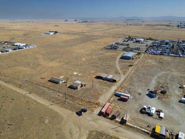

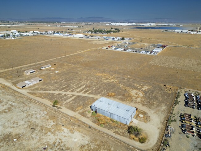

Property Detail
39010 12Th St E
3022-015-023
TR=7672 POR OF W 1/2 OF N 1/2 OF LOT 4
Lightindustrial
LOS ANGELES
PDM1
California
C and X Area of minimal flood hazard, usually depicted on FIRMs as above the 500-year flood level.
4
2024
4.51 AC
2025
Antelope Valley
910504
Los Angeles
8,224 SF
Los Angeles-Long Beach-Glendale, CA
NEARBY LISTINGS FOR SALE OR LEASE
DEMOGRAPHICS near 39010 12Th St E
1 mile
3 mile
5 mile
2024 Total Population
8,959
77,829
146,224
2029 Population
8,958
77,684
145,579
Pop Growth 2024-2029
(0.01%)
(0.19%)
(0.44%)
Average Age
33
36
37
2024 Total Households
2,806
23,153
41,741
HH Growth 2024-2029
(0.11%)
(0.19%)
(0.50%)
Median Household Inc
$44,558
$62,247
$75,312
Avg Household Size
3.10
3.30
3.40
2024 Avg HH Vehicles
1.00
2.00
2.00
Median Home Value
$309,434
$386,881
$439,406
Median Year Built
1979
1984
1987
Nearby Places
Map Layers
Map Styles
 Street
 Aerial
Transit
 Traffic
 Biking
Places
Listings with unknown addresses are not visible on the map
- Restaurants
- Banks
- Shops
- Fitness
- Groceries
PUBLIC TRANSPORTATION
COMMUTER RAIL
Palmdale (Antelope Valley Line - Southern California Regional Rail Authority (Metrolink))
Drive
Walk
Distance
Palmdale (Antelope Valley Line - Southern California Regional Rail Authority (Metrolink))
5 min
2.1 mi
Vincent Grade/Acton (Antelope Valley Line - Southern California Regional Rail Authority (Metrolink))
Drive
Walk
Distance
Vincent Grade/Acton (Antelope Valley Line - Southern California Regional Rail Authority (Metrolink))
14 min
7.9 mi
SALE & LEASE HISTORY
LISTING DATE
SALE/LEASE

Sep 30, 2025
For Sale
Nearby Properties
Address
Land Use
TOTAL SIZE
Lot Size
Zoning
Address
Land Use
TOTAL SIZE
Lot Size
Zoning
2,861,890 SF
528.69 AC
POMA-A25*
Address
Land Use
TOTAL SIZE
Lot Size
Zoning
358,828 SF
26.23 AC
PDR17000
Address
Land Use
TOTAL SIZE
Lot Size
Zoning
449,135 SF
29.76 AC
PDRA
Address
Land Use
TOTAL SIZE
Lot Size
Zoning
130,392 SF
26.91 AC
PDCPD*
Address
Land Use
TOTAL SIZE
Lot Size
Zoning
167,366 SF
15.36 AC
PDC3
Address
Land Use
TOTAL SIZE
Lot Size
Zoning
201,615 SF
20.60 AC
PDC4
Address
Land Use
TOTAL SIZE
Lot Size
Zoning
88,750 SF
9.28 AC
PDM1 1/2*
Address
Land Use
TOTAL SIZE
Lot Size
Zoning
128,353 SF
9.49 AC
PDCPD-R1*
Address
Land Use
TOTAL SIZE
Lot Size
Zoning
50,735 SF
PDCPD
Address
Land Use
TOTAL SIZE
Lot Size
Zoning
78,492 SF
3.25 AC
PDCPD
Address
Land Use
TOTAL SIZE
Lot Size
Zoning
139,513 SF
4.07 AC
PDCPD
Address
Land Use
TOTAL SIZE
Lot Size
Zoning
60,644 SF
3.89 AC
PDMX*
Address
Land Use
TOTAL SIZE
Lot Size
Zoning
103,503 SF
3.61 AC
PDC2
Address
Land Use
TOTAL SIZE
Lot Size
Zoning
64,818 SF
2.30 AC
PDCP
Address
Land Use
TOTAL SIZE
Lot Size
Zoning
57,382 SF
2.52 AC
PDC4*
Address
Land Use
TOTAL SIZE
Lot Size
Zoning
221,827 SF
14.90 AC
PDRPD10U-R
Address
Land Use
TOTAL SIZE
Lot Size
Zoning
157,021 SF
PDRN4
Address
Land Use
TOTAL SIZE
Lot Size
Zoning
59,577 SF
0.59 AC
PDR17000
Address
Land Use
TOTAL SIZE
Lot Size
Zoning
209,328 SF
6.35 AC
PDC3-RPD15
Address
Land Use
TOTAL SIZE
Lot Size
Zoning
69,555 SF
7.55 AC
PDMPD*
Address
Land Use
TOTAL SIZE
Lot Size
Zoning
147,297 SF
10.57 AC
POC4
Address
Land Use
TOTAL SIZE
Lot Size
Zoning
68,943 SF
2.72 AC
POC4
Address
Land Use
TOTAL SIZE
Lot Size
Zoning
71,394 SF
2.93 AC
PDCPD*
Address
Land Use
TOTAL SIZE
Lot Size
Zoning
76,609 SF
3.61 AC
PDM2
Address
Land Use
TOTAL SIZE
Lot Size
Zoning
115,684 SF
10.46 AC
PDRA
Address
Land Use
TOTAL SIZE
Lot Size
Zoning
2,908,124 SF
126.15 AC
LCM21/2*
Address
Land Use
TOTAL SIZE
Lot Size
Zoning
36,033 SF
3.81 AC
PDMPD*
Address
Land Use
TOTAL SIZE
Lot Size
Zoning
144,471 SF
12.96 AC
PDCPD-MPD*
Address
Land Use
TOTAL SIZE
Lot Size
Zoning
80,981 SF
7.11 AC
PDC3
The World's #1 Commercial Real Estate Marketplace
Connect with us
© 2026 CoStar Group
The information above has been obtained from sources believed reliable. While we do not doubt its accuracy we have not verified it and make no guarantee, warranty or representation about it. It is your responsibility to independently confirm its accuracy and completeness. Any projections, opinions, assumptions, or estimates used are for example only and do not represent the current or future performance of the property. The value of this transaction to you depends on tax and other factors which should be evaluated by your tax, financial, and legal advisors. You and your advisors should conduct a careful, independent investigation of the property to determine to your satisfaction the suitability of the property for your needs.