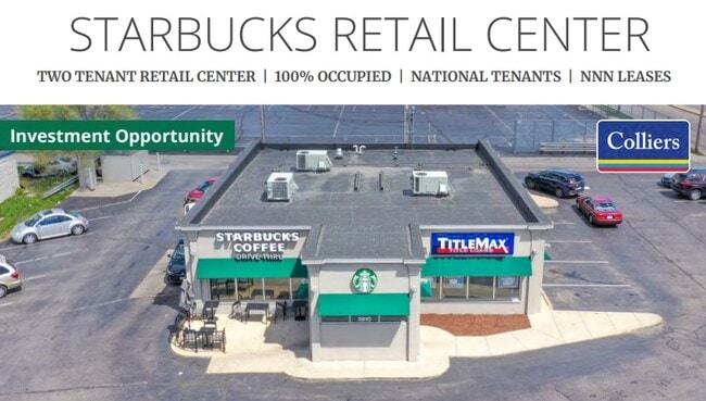
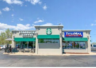
Property Record
3910 75Th St, Kenosha, WI 53142

Property Detail
3910 75Th St
02-122-02-483-005
LOTS 26, 27, 28 & 29 O'NEILL'S GRAND VIEW SUB EXC THE S 7 FT FOR RD V 1320 P 681 BEING PT OF SE 1/4 SEC 2 T 1 R 22 1989 (2005
Commercialnec
KENOSHA
B2
Wisconsin
B and X Area of moderate flood hazard, usually the area between the limits of the 100-year and 500-year floods.
26-29
2025
0.44 AC
2025
Kenosha East
001500
Chicago
2,950 SF
Kenosha, WI
NEARBY LISTINGS FOR SALE OR LEASE
DEMOGRAPHICS near 3910 75Th St
1 mile
3 mile
5 mile
2025 Total Population
15,214
79,920
118,765
2030 Population
14,961
79,003
117,879
Pop Growth 2025-2030
(1.66%)
(1.15%)
(0.75%)
Average Age
40
40
40
2025 Total Households
6,143
31,517
47,002
HH Growth 2025-2030
(1.71%)
(1.19%)
(0.73%)
Median Household Inc
$76,463
$66,894
$70,561
Avg Household Size
2.40
2.40
2.40
2025 Avg HH Vehicles
2.00
2.00
2.00
Median Home Value
$192,056
$224,669
$250,624
Median Year Built
1954
1964
1972
Nearby Places
Map Layers
Map Styles
 Street
 Aerial
Layers
 Traffic
 Biking
Places
Listings with unknown addresses are not visible on the map
- Restaurants
- Banks
- Shops
- Fitness
- Groceries
PUBLIC TRANSPORTATION
COMMUTER RAIL
Kenosha Station (Union Pacific North Line - Northeast Illinois Regional Commuter Railroad (Metra))
Drive
Walk
Distance
Kenosha Station (Union Pacific North Line - Northeast Illinois Regional Commuter Railroad (Metra))
6 min
2.8 mi
Winthrop Harbor Station (Union Pacific North Line - Northeast Illinois Regional Commuter Railroad (Metra))
Drive
Walk
Distance
Winthrop Harbor Station (Union Pacific North Line - Northeast Illinois Regional Commuter Railroad (Metra))
15 min
7.8 mi
AIRPORT
General Mitchell International
Drive
Walk
Distance
General Mitchell International
42 min
33.0 mi
Freight Ports
Port Milwaukee
Drive
Walk
Distance
Port Milwaukee
47 min
36.9 mi
SALE & LEASE HISTORY
LISTING DATE
SALE/LEASE

May 24, 2021
For Sale
Jul 16, 2020
For Lease
Nearby Properties
Address
Land Use
TOTAL SIZE
Lot Size
Zoning
Address
Land Use
TOTAL SIZE
Lot Size
Zoning
731,186 SF
81.94 AC
M2
Address
Land Use
TOTAL SIZE
Lot Size
Zoning
10.37 AC
IP
Address
Land Use
TOTAL SIZE
Lot Size
Zoning
35,092 SF
26.34 AC
B2
Address
Land Use
TOTAL SIZE
Lot Size
Zoning
357,885 SF
26.58 AC
M1
Address
Land Use
TOTAL SIZE
Lot Size
Zoning
3,721 SF
24.57 AC
FW
Address
Land Use
TOTAL SIZE
Lot Size
Zoning
26,016 SF
14.02 AC
FW
Address
Land Use
TOTAL SIZE
Lot Size
Zoning
52,016 SF
25.40 AC
FW
Address
Land Use
TOTAL SIZE
Lot Size
Zoning
194,281 SF
19.13 AC
B2
Address
Land Use
TOTAL SIZE
Lot Size
Zoning
85,847 SF
5.03 AC
RM2
Address
Land Use
TOTAL SIZE
Lot Size
Zoning
4,643 SF
60 AC
Address
Land Use
TOTAL SIZE
Lot Size
Zoning
32,245 SF
22 AC
RM2
Address
Land Use
TOTAL SIZE
Lot Size
Zoning
279,872 SF
14.60 AC
M2
Address
Land Use
TOTAL SIZE
Lot Size
Zoning
14.40 AC
Address
Land Use
TOTAL SIZE
Lot Size
Zoning
2,963 SF
13.16 AC
Address
Land Use
TOTAL SIZE
Lot Size
Zoning
7,830 SF
16 AC
FW
Address
Land Use
TOTAL SIZE
Lot Size
Zoning
31,650 SF
7.62 AC
FW
Address
Land Use
TOTAL SIZE
Lot Size
Zoning
147,040 SF
2.50 AC
RM2
Address
Land Use
TOTAL SIZE
Lot Size
Zoning
319,640 SF
19.20 AC
M1
Address
Land Use
TOTAL SIZE
Lot Size
Zoning
63,500 SF
5.81 AC
RM2
Address
Land Use
TOTAL SIZE
Lot Size
Zoning
17,174 SF
10.31 AC
RS2
Address
Land Use
TOTAL SIZE
Lot Size
Zoning
161,640 SF
14.88 AC
B2
Address
Land Use
TOTAL SIZE
Lot Size
Zoning
28,815 SF
1.04 AC
B3
Address
Land Use
TOTAL SIZE
Lot Size
Zoning
76,848 SF
8.09 AC
BASE
Address
Land Use
TOTAL SIZE
Lot Size
Zoning
61,318 SF
6.17 AC
B2
Address
Land Use
TOTAL SIZE
Lot Size
Zoning
135,468 SF
13.56 AC
B2
Address
Land Use
TOTAL SIZE
Lot Size
Zoning
98,701 SF
0.62 AC
B4
Address
Land Use
TOTAL SIZE
Lot Size
Zoning
124,000 SF
7.71 AC
B2
Address
Land Use
TOTAL SIZE
Lot Size
Zoning
96,150 SF
9.62 AC
B2
Address
Land Use
TOTAL SIZE
Lot Size
Zoning
92,358 SF
8.72 AC
B2
Address
Land Use
TOTAL SIZE
Lot Size
Zoning
60,657 SF
4.42 AC
RM3
The World's #1 Commercial Real Estate Marketplace
Connect with us
© 2026 CoStar Group
The information above has been obtained from sources believed reliable. While we do not doubt its accuracy we have not verified it and make no guarantee, warranty or representation about it. It is your responsibility to independently confirm its accuracy and completeness. Any projections, opinions, assumptions, or estimates used are for example only and do not represent the current or future performance of the property. The value of this transaction to you depends on tax and other factors which should be evaluated by your tax, financial, and legal advisors. You and your advisors should conduct a careful, independent investigation of the property to determine to your satisfaction the suitability of the property for your needs.