Property Record
3910 E Puetz Rd, Oak Creek, WI 53154


Save to a Folder
{{folder.Name}}
{{folder.ListingIds.length}} Properties
{{folder.ListingIds.length}} Property
Create a New Folder
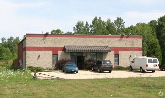
Property Detail
3910 E Puetz Rd
Milwaukee-Waukesha, WI
PART OF SE 1/4 SEC 14-5-22, COM 466.58 FT W OF SE COR & 208.67 FT N OF S LI SD 1/4 SEC; TH W 75 FT, S 208.67 FT, W TO A PT 912.88 FT W OF SE COR, N 487.60 FT, E 466.30 FT, TH S TO P.O.C. EXC S 33 FT RESERVED FOR HWY. CONT. 4.641 ACS.
822-9960-001
Milwaukee
Commercialnec
Wisconsin
B and X Area of moderate flood hazard, usually the area between the limits of the 100-year and 500-year floods.
4.64 AC
2024
Milwaukee SE
2025
Milwaukee/Madison
160202
NEARBY LISTINGS FOR SALE OR LEASE
DEMOGRAPHICS near 3910 E Puetz Rd
1 mile
3 mile
5 mile
2025 Total Population
6,931
37,520
71,704
2030 Population
6,901
37,176
71,337
Pop Growth 2025-2030
(0.43%)
(0.92%)
(0.51%)
Average Age
42
41
41
2025 Total Households
2,859
15,395
30,283
HH Growth 2025-2030
(0.63%)
(1.08%)
(0.61%)
Median Household Inc
$87,287
$89,746
$85,151
Avg Household Size
2.30
2.40
2.30
2025 Avg HH Vehicles
2.00
2.00
2.00
Median Home Value
$282,050
$278,814
$269,768
Median Year Built
1972
1968
1973
Nearby Places
Map Layers
Map Styles
 Street
 Aerial
Layers
 Traffic
 Biking
Places
Listings with unknown addresses are not visible on the map
- Restaurants
- Banks
- Shops
- Fitness
- Groceries
PUBLIC TRANSPORTATION
COMMUTER RAIL
Drive
Walk
Distance
17 min
7.6 mi
AIRPORT
General Mitchell International
Drive
Walk
Distance
General Mitchell International
16 min
7.8 mi
Freight Ports
Port Milwaukee
Drive
Walk
Distance
Port Milwaukee
23 min
10.3 mi
Nearby Properties
Address
Land Use
TOTAL SIZE
Lot Size
Zoning
Address
Land Use
TOTAL SIZE
Lot Size
Zoning
27.30 AC
RESIDENTIA
Address
Land Use
TOTAL SIZE
Lot Size
Zoning
9.24 AC
RESIDENTIA
Address
Land Use
TOTAL SIZE
Lot Size
Zoning
4.72 AC
Address
Land Use
TOTAL SIZE
Lot Size
Zoning
9.36 AC
RESIDENTIA
Address
Land Use
TOTAL SIZE
Lot Size
Zoning
7.22 AC
RESIDENTIA
Address
Land Use
TOTAL SIZE
Lot Size
Zoning
3.78 AC
Address
Land Use
TOTAL SIZE
Lot Size
Zoning
Address
Land Use
TOTAL SIZE
Lot Size
Zoning
Address
Land Use
TOTAL SIZE
Lot Size
Zoning
Address
Land Use
TOTAL SIZE
Lot Size
Zoning
Address
Land Use
TOTAL SIZE
Lot Size
Zoning
8.80 AC
RESIDENTIA
Address
Land Use
TOTAL SIZE
Lot Size
Zoning
10.57 AC
Address
Land Use
TOTAL SIZE
Lot Size
Zoning
Address
Land Use
TOTAL SIZE
Lot Size
Zoning
8.16 AC
RESIDENTIA
Address
Land Use
TOTAL SIZE
Lot Size
Zoning
Address
Land Use
TOTAL SIZE
Lot Size
Zoning
10.20 AC
Address
Land Use
TOTAL SIZE
Lot Size
Zoning
9,647 SF
7.82 AC
RESIDENTIA
Address
Land Use
TOTAL SIZE
Lot Size
Zoning
7.14 AC
RESIDENTIA
Address
Land Use
TOTAL SIZE
Lot Size
Zoning
36.60 AC
Address
Land Use
TOTAL SIZE
Lot Size
Zoning
Address
Land Use
TOTAL SIZE
Lot Size
Zoning
6.64 AC
RESIDENTIA
Address
Land Use
TOTAL SIZE
Lot Size
Zoning
Address
Land Use
TOTAL SIZE
Lot Size
Zoning
5,435 SF
7.24 AC
RESIDENTIA
Address
Land Use
TOTAL SIZE
Lot Size
Zoning
Address
Land Use
TOTAL SIZE
Lot Size
Zoning
Address
Land Use
TOTAL SIZE
Lot Size
Zoning
3.40 AC
Address
Land Use
TOTAL SIZE
Lot Size
Zoning
3.19 AC
RESIDENTIA
Address
Land Use
TOTAL SIZE
Lot Size
Zoning
7.71 AC
RESIDENTIA
Address
Land Use
TOTAL SIZE
Lot Size
Zoning
Address
Land Use
TOTAL SIZE
Lot Size
Zoning
2.89 AC
The World's #1 Commercial Real Estate Marketplace
Connect with us
© 2026 CoStar Group
The information above has been obtained from sources believed reliable. While we do not doubt its accuracy we have not verified it and make no guarantee, warranty or representation about it. It is your responsibility to independently confirm its accuracy and completeness. Any projections, opinions, assumptions, or estimates used are for example only and do not represent the current or future performance of the property. The value of this transaction to you depends on tax and other factors which should be evaluated by your tax, financial, and legal advisors. You and your advisors should conduct a careful, independent investigation of the property to determine to your satisfaction the suitability of the property for your needs.