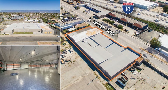
Property Record
395 E Valley Blvd, Colton, CA 92324


Current Lease Availabilities
Property Detail
395 E Valley Blvd
Riverside-San Bernardino-Ontario, CA
COLTON CITY LOTS 31 AND 32 BLK 106 AND WLY 50 FT 11TH ST VAC ADJ SD LOT 32 ON E AND S 1/2 ALLEY VAC ADJ SD LOTS 31 AND 32 ON N EX S 20 FT SD LOTS AND EX S 20 FT SD VAC ST AND LOTS 17 AND 18 BLK 105 AND S 1/2 ALLEY VAC ADJ SD LOTS ON N AND E 30 FT 11T
0162-191-29
San Bernardino
Warehouse
California
B and X Area of moderate flood hazard, usually the area between the limits of the 100-year and 500-year floods.
31,32
2025
0.58 AC
2025
San Bernardino
007002
Inland Empire (California)
20,474 SF
NEARBY LISTINGS FOR SALE OR LEASE
DEMOGRAPHICS near 395 E Valley Blvd
1 mile
3 mile
5 mile
2025 Total Population
14,619
100,186
298,167
2030 Population
14,713
101,146
301,952
Pop Growth 2025-2030
+ 0.64%
+ 0.96%
+ 1.27%
Average Age
35
36
35
2025 Total Households
4,108
29,865
84,969
HH Growth 2025-2030
+ 0.61%
+ 1.05%
+ 1.35%
Median Household Inc
$60,819
$72,044
$71,408
Avg Household Size
3.50
3.30
3.40
2025 Avg HH Vehicles
2.00
2.00
2.00
Median Home Value
$433,706
$429,856
$445,082
Median Year Built
1957
1976
1974
Nearby Places
Map Layers
Map Styles
 Street
 Aerial
Layers
 Traffic
 Biking
Places
Listings with unknown addresses are not visible on the map
- Restaurants
- Banks
- Shops
- Fitness
- Groceries
PUBLIC TRANSPORTATION
COMMUTER RAIL
San Bernardino (Inland Empire-Orange County Line - Southern California Regional Rail Authority (Metrolink), San Bernardino Line - Southern California Regional Rail Authority (Metrolink))
Drive
Walk
Distance
San Bernardino (Inland Empire-Orange County Line - Southern California Regional Rail Authority (Metrolink), San Bernardino Line - Southern California Regional Rail Authority (Metrolink))
8 min
3.1 mi
Drive
Walk
Distance
8 min
3.4 mi
AIRPORT
Ontario International
Drive
Walk
Distance
Ontario International
22 min
16.9 mi
Nearby Properties
Address
Land Use
TOTAL SIZE
Lot Size
Zoning
Address
Land Use
TOTAL SIZE
Lot Size
Zoning
457,253 SF
20.14 AC
Address
Land Use
TOTAL SIZE
Lot Size
Zoning
308,030 SF
16.20 AC
Address
Land Use
TOTAL SIZE
Lot Size
Zoning
1,032,072 SF
61.74 AC
Address
Land Use
TOTAL SIZE
Lot Size
Zoning
411,707 SF
19.34 AC
Address
Land Use
TOTAL SIZE
Lot Size
Zoning
330,420 SF
15.31 AC
Address
Land Use
TOTAL SIZE
Lot Size
Zoning
340,120 SF
36.36 AC
Address
Land Use
TOTAL SIZE
Lot Size
Zoning
1,081,199 SF
49.77 AC
Address
Land Use
TOTAL SIZE
Lot Size
Zoning
300,188 SF
11.98 AC
Address
Land Use
TOTAL SIZE
Lot Size
Zoning
182,624 SF
16.07 AC
Address
Land Use
TOTAL SIZE
Lot Size
Zoning
245,476 SF
15.61 AC
Address
Land Use
TOTAL SIZE
Lot Size
Zoning
391,468 SF
16.73 AC
Address
Land Use
TOTAL SIZE
Lot Size
Zoning
206,244 SF
15.22 AC
Address
Land Use
TOTAL SIZE
Lot Size
Zoning
210,418 SF
12.09 AC
Address
Land Use
TOTAL SIZE
Lot Size
Zoning
225,324 SF
11.03 AC
Address
Land Use
TOTAL SIZE
Lot Size
Zoning
851,880 SF
42.20 AC
Address
Land Use
TOTAL SIZE
Lot Size
Zoning
178,400 SF
8.23 AC
Address
Land Use
TOTAL SIZE
Lot Size
Zoning
549,796 SF
13.61 AC
Address
Land Use
TOTAL SIZE
Lot Size
Zoning
182,446 SF
9.01 AC
Address
Land Use
TOTAL SIZE
Lot Size
Zoning
151,859 SF
7.23 AC
Address
Land Use
TOTAL SIZE
Lot Size
Zoning
592,710 SF
28.89 AC
Address
Land Use
TOTAL SIZE
Lot Size
Zoning
318,940 SF
14.26 AC
Address
Land Use
TOTAL SIZE
Lot Size
Zoning
16,000 SF
11.17 AC
Address
Land Use
TOTAL SIZE
Lot Size
Zoning
153,093 SF
2.69 AC
Address
Land Use
TOTAL SIZE
Lot Size
Zoning
122,738 SF
10.77 AC
Address
Land Use
TOTAL SIZE
Lot Size
Zoning
345,237 SF
14.52 AC
Address
Land Use
TOTAL SIZE
Lot Size
Zoning
166,376 SF
18.75 AC
Address
Land Use
TOTAL SIZE
Lot Size
Zoning
198,818 SF
8.94 AC
Address
Land Use
TOTAL SIZE
Lot Size
Zoning
352,082 SF
13.57 AC
Address
Land Use
TOTAL SIZE
Lot Size
Zoning
179,550 SF
8.04 AC
The World's #1 Commercial Real Estate Marketplace
Connect with us
© 2026 CoStar Group
The information above has been obtained from sources believed reliable. While we do not doubt its accuracy we have not verified it and make no guarantee, warranty or representation about it. It is your responsibility to independently confirm its accuracy and completeness. Any projections, opinions, assumptions, or estimates used are for example only and do not represent the current or future performance of the property. The value of this transaction to you depends on tax and other factors which should be evaluated by your tax, financial, and legal advisors. You and your advisors should conduct a careful, independent investigation of the property to determine to your satisfaction the suitability of the property for your needs.