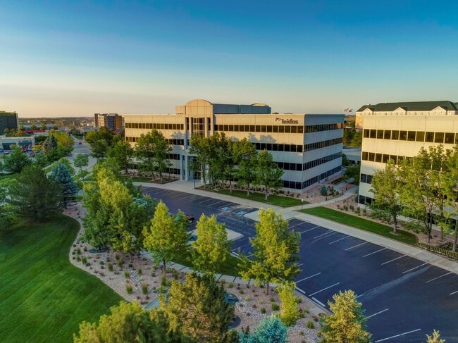
Property Record
3950 Lewiston St, Aurora, CO 80011


Property Detail
3950 Lewiston St
Denver-Aurora-Centennial, CO
SUB:GATEWAY PARK IV SUB FLG 4 AMENDMENT NO 1 BLK:1 LOT:1
1821-20-4-02-001
Adams
Officebuilding
Colorado
2024
1
2025
4.74 AC
008309
East I-70/Montbello
101,752 SF
Denver
NEARBY LISTINGS FOR SALE OR LEASE
DEMOGRAPHICS near 3950 Lewiston St
1 mile
3 mile
5 mile
2025 Total Population
8,327
108,617
239,075
2030 Population
8,537
111,560
247,345
Pop Growth 2025-2030
+ 2.52%
+ 2.71%
+ 3.46%
Average Age
34
35
35
2025 Total Households
2,999
33,055
77,834
HH Growth 2025-2030
+ 1.90%
+ 3.09%
+ 3.70%
Median Household Inc
$87,883
$84,674
$83,010
Avg Household Size
2.60
3.10
2.90
2025 Avg HH Vehicles
2.00
2.00
2.00
Median Home Value
$409,432
$430,667
$459,007
Median Year Built
2008
1996
1992
Nearby Places
Map Layers
Map Styles
 Street
 Aerial
Transit
 Traffic
 Biking
Places
Listings with unknown addresses are not visible on the map
- Restaurants
- Banks
- Shops
- Fitness
- Groceries
PUBLIC TRANSPORTATION
COMMUTER RAIL
Drive
Walk
Distance
4 min
1.4 mi
Drive
Walk
Distance
8 min
3.4 mi
AIRPORT
Denver International
Drive
Walk
Distance
Denver International
15 min
11.9 mi
SALE & LEASE HISTORY
LISTING DATE
SALE/LEASE

Sep 28, 2016
For Lease
Sep 25, 2016
For Lease
Nearby Properties
Address
Land Use
TOTAL SIZE
Lot Size
Zoning
Address
Land Use
TOTAL SIZE
Lot Size
Zoning
368,450 SF
48.59 AC
Address
Land Use
TOTAL SIZE
Lot Size
Zoning
353,829 SF
4.51 AC
Address
Land Use
TOTAL SIZE
Lot Size
Zoning
258,315 SF
16.83 AC
Address
Land Use
TOTAL SIZE
Lot Size
Zoning
244,271 SF
15.30 AC
Address
Land Use
TOTAL SIZE
Lot Size
Zoning
525,050 SF
105.06 AC
Address
Land Use
TOTAL SIZE
Lot Size
Zoning
87,346 SF
1.76 AC
RFBAD
Address
Land Use
TOTAL SIZE
Lot Size
Zoning
868,780 SF
105.02 AC
Address
Land Use
TOTAL SIZE
Lot Size
Zoning
876,549 SF
46.65 AC
Address
Land Use
TOTAL SIZE
Lot Size
Zoning
200,105 SF
34.54 AC
C-MU-20
Address
Land Use
TOTAL SIZE
Lot Size
Zoning
335,757 SF
36.88 AC
CMP-EI2
Address
Land Use
TOTAL SIZE
Lot Size
Zoning
704,978 SF
36.17 AC
Address
Land Use
TOTAL SIZE
Lot Size
Zoning
102,444 SF
3.76 AC
GTWY
Address
Land Use
TOTAL SIZE
Lot Size
Zoning
691,200 SF
38.09 AC
Address
Land Use
TOTAL SIZE
Lot Size
Zoning
273,184 SF
1.89 AC
Address
Land Use
TOTAL SIZE
Lot Size
Zoning
140.42 AC
Address
Land Use
TOTAL SIZE
Lot Size
Zoning
111,077 SF
3.06 AC
Address
Land Use
TOTAL SIZE
Lot Size
Zoning
550,031 SF
37.73 AC
Address
Land Use
TOTAL SIZE
Lot Size
Zoning
185,812 SF
20.93 AC
C-MU-20
Address
Land Use
TOTAL SIZE
Lot Size
Zoning
134,052 SF
6.77 AC
C-MX
Address
Land Use
TOTAL SIZE
Lot Size
Zoning
545,010 SF
35.35 AC
Address
Land Use
TOTAL SIZE
Lot Size
Zoning
512,720 SF
42.32 AC
Address
Land Use
TOTAL SIZE
Lot Size
Zoning
522,120 SF
27.70 AC
Address
Land Use
TOTAL SIZE
Lot Size
Zoning
500,358 SF
23.59 AC
Address
Land Use
TOTAL SIZE
Lot Size
Zoning
548,510 SF
27.26 AC
Address
Land Use
TOTAL SIZE
Lot Size
Zoning
452,400 SF
20.99 AC
Address
Land Use
TOTAL SIZE
Lot Size
Zoning
269,622 SF
12.90 AC
Address
Land Use
TOTAL SIZE
Lot Size
Zoning
432,600 SF
30.98 AC
Address
Land Use
TOTAL SIZE
Lot Size
Zoning
461,580 SF
23.56 AC
Address
Land Use
TOTAL SIZE
Lot Size
Zoning
419,630 SF
24.34 AC
Address
Land Use
TOTAL SIZE
Lot Size
Zoning
58,997 SF
2.05 AC
S-CC-5X
The World's #1 Commercial Real Estate Marketplace
Connect with us
© 2026 CoStar Group
The information above has been obtained from sources believed reliable. While we do not doubt its accuracy we have not verified it and make no guarantee, warranty or representation about it. It is your responsibility to independently confirm its accuracy and completeness. Any projections, opinions, assumptions, or estimates used are for example only and do not represent the current or future performance of the property. The value of this transaction to you depends on tax and other factors which should be evaluated by your tax, financial, and legal advisors. You and your advisors should conduct a careful, independent investigation of the property to determine to your satisfaction the suitability of the property for your needs.