Property Record
3950 N Main St, Fall River, MA 02720

Property Detail
3950 N Main St
FALL-000003X-000000-000044
Bristol
Commercialbuilding
Massachusetts
S
44
B and X Area of moderate flood hazard, usually the area between the limits of the 100-year and 500-year floods.
0.61 AC
2025
Attleboro/New Bedford
2025
Boston
642100
Providence-Warwick, RI-MA
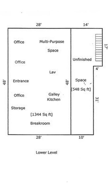
3,784 SF
NEARBY LISTINGS FOR SALE OR LEASE
DEMOGRAPHICS near 3950 N Main St
1 mile
3 mile
5 mile
2025 Total Population
6,250
43,077
115,112
2030 Population
6,429
43,966
117,289
Pop Growth 2025-2030
+ 2.86%
+ 2.06%
+ 1.89%
Average Age
43
43
41
2025 Total Households
2,686
17,749
48,876
HH Growth 2025-2030
+ 3.05%
+ 2.17%
+ 1.98%
Median Household Inc
$85,370
$84,639
$65,908
Avg Household Size
2.20
2.30
2.30
2025 Avg HH Vehicles
2.00
2.00
2.00
Median Home Value
$430,893
$427,953
$421,599
Median Year Built
1978
1962
1951
Nearby Places
Map Layers
Map Styles
 Street
 Aerial
Transit
 Traffic
 Biking
Places
Listings with unknown addresses are not visible on the map
- Restaurants
- Banks
- Shops
- Fitness
- Groceries
PUBLIC TRANSPORTATION
AIRPORT
Rhode Island Tf Green International
Drive
Walk
Distance
Rhode Island Tf Green International
41 min
25.2 mi
Freight Ports
Port of New Bedford Harbor
Drive
Walk
Distance
Port of New Bedford Harbor
23 min
17.7 mi
SALE & LEASE HISTORY
LISTING DATE
SALE/LEASE

Oct 31, 2023
For Lease
Nearby Properties
Address
Land Use
TOTAL SIZE
Lot Size
Zoning
Address
Land Use
TOTAL SIZE
Lot Size
Zoning
634,182 SF
63.86 AC
N/A
Address
Land Use
TOTAL SIZE
Lot Size
Zoning
174.51 AC
I
Address
Land Use
TOTAL SIZE
Lot Size
Zoning
226,473 SF
29.10 AC
R1
Address
Land Use
TOTAL SIZE
Lot Size
Zoning
203,989 SF
2.01 AC
A-2
Address
Land Use
TOTAL SIZE
Lot Size
Zoning
14.30 AC
G
Address
Land Use
TOTAL SIZE
Lot Size
Zoning
0.06 AC
A-2
Address
Land Use
TOTAL SIZE
Lot Size
Zoning
90.84 AC
N/A
Address
Land Use
TOTAL SIZE
Lot Size
Zoning
115,119 SF
151.54 AC
WR
Address
Land Use
TOTAL SIZE
Lot Size
Zoning
599,760 SF
33.60 AC
INPK
Address
Land Use
TOTAL SIZE
Lot Size
Zoning
105,949 SF
25.21 AC
R1
Address
Land Use
TOTAL SIZE
Lot Size
Zoning
387.83 AC
I
Address
Land Use
TOTAL SIZE
Lot Size
Zoning
104,822 SF
16.61 AC
R1
Address
Land Use
TOTAL SIZE
Lot Size
Zoning
17.18 AC
IND
Address
Land Use
TOTAL SIZE
Lot Size
Zoning
53.87 AC
N/A
Address
Land Use
TOTAL SIZE
Lot Size
Zoning
136,622 SF
55.54 AC
S
Address
Land Use
TOTAL SIZE
Lot Size
Zoning
10 AC
B
Address
Land Use
TOTAL SIZE
Lot Size
Zoning
18.65 AC
A-2
Address
Land Use
TOTAL SIZE
Lot Size
Zoning
85,692 SF
4.05 AC
S
Address
Land Use
TOTAL SIZE
Lot Size
Zoning
255,600 SF
12.46 AC
R4
Address
Land Use
TOTAL SIZE
Lot Size
Zoning
28,438 SF
245 AC
C
Address
Land Use
TOTAL SIZE
Lot Size
Zoning
497,656 SF
30.47 AC
INPK
Address
Land Use
TOTAL SIZE
Lot Size
Zoning
808 AC
WR
Address
Land Use
TOTAL SIZE
Lot Size
Zoning
26.51 AC
G
Address
Land Use
TOTAL SIZE
Lot Size
Zoning
3,150 SF
7.91 AC
S
Address
Land Use
TOTAL SIZE
Lot Size
Zoning
155,364 SF
15.27 AC
C
Address
Land Use
TOTAL SIZE
Lot Size
Zoning
119,932 SF
4.79 AC
G
Address
Land Use
TOTAL SIZE
Lot Size
Zoning
136,814 SF
4.07 AC
IND
Address
Land Use
TOTAL SIZE
Lot Size
Zoning
341,531 SF
17.57 AC
INPK
Address
Land Use
TOTAL SIZE
Lot Size
Zoning
114,424 SF
12.94 AC
C
Address
Land Use
TOTAL SIZE
Lot Size
Zoning
430.04 AC
WR
The World's #1 Commercial Real Estate Marketplace
Connect with us
© 2026 CoStar Group
The information above has been obtained from sources believed reliable. While we do not doubt its accuracy we have not verified it and make no guarantee, warranty or representation about it. It is your responsibility to independently confirm its accuracy and completeness. Any projections, opinions, assumptions, or estimates used are for example only and do not represent the current or future performance of the property. The value of this transaction to you depends on tax and other factors which should be evaluated by your tax, financial, and legal advisors. You and your advisors should conduct a careful, independent investigation of the property to determine to your satisfaction the suitability of the property for your needs.