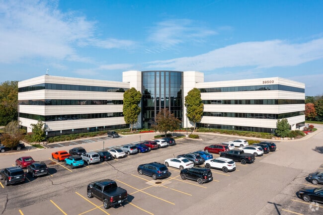
Property Record
39500 High Pointe Blvd, Novi, MI 48375


Save to a Folder
{{folder.Name}}
{{folder.ListingIds.length}} Properties
{{folder.ListingIds.length}} Property
Create a New Folder
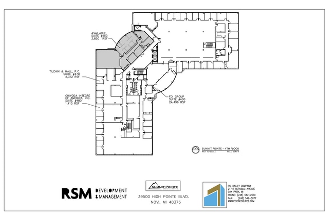
Current Lease Availabilities
Property Detail
39500 High Pointe Blvd
22-36-200-036
T1N, R8E, SEC 36 PART OF NE 1/4 BEG AT PT DIST N 01-38-53 W 965.65 FT FROM E1/4 COR, TH S 87-35-02 W 785 FT, TH N 02-24-58 W
Commercialnec
OAKLAND
OSC
Michigan
B and X Area of moderate flood hazard, usually the area between the limits of the 100-year and 500-year floods.
9.37 AC
2025
Central I-96 Corridor
2023
Detroit
136700
Detroit-Warren-Dearborn, MI
129,448 SF
NEARBY LISTINGS FOR SALE OR LEASE
DEMOGRAPHICS near 39500 High Pointe Blvd
1 mile
3 mile
5 mile
2025 Total Population
9,830
73,940
184,546
2030 Population
9,940
74,383
185,058
Pop Growth 2025-2030
+ 1.12%
+ 0.60%
+ 0.28%
Average Age
42
42
44
2025 Total Households
3,901
32,157
76,948
HH Growth 2025-2030
+ 1.18%
+ 0.60%
+ 0.29%
Median Household Inc
$116,077
$102,453
$108,647
Avg Household Size
2.50
2.30
2.30
2025 Avg HH Vehicles
2.00
2.00
2.00
Median Home Value
$366,666
$380,001
$370,325
Median Year Built
1978
1982
1981
Nearby Places
Map Layers
Map Styles
 Street
 Aerial
Layers
 Traffic
 Biking
Places
Listings with unknown addresses are not visible on the map
- Restaurants
- Banks
- Shops
- Fitness
- Groceries
PUBLIC TRANSPORTATION
AIRPORT
Detroit Metro Wayne County
Drive
Walk
Distance
Detroit Metro Wayne County
29 min
22.9 mi
Windsor International
Drive
Walk
Distance
Windsor International
56 min
37.0 mi
Freight Ports
Port of Toledo
Drive
Walk
Distance
Port of Toledo
78 min
64.5 mi
Nearby Properties
Address
Land Use
TOTAL SIZE
Lot Size
Zoning
Address
Land Use
TOTAL SIZE
Lot Size
Zoning
1,393,561 SF
123.23 AC
AI
Address
Land Use
TOTAL SIZE
Lot Size
Zoning
886 SF
26.58 AC
GATEWY
Address
Land Use
TOTAL SIZE
Lot Size
Zoning
57.28 AC
RM-1
Address
Land Use
TOTAL SIZE
Lot Size
Zoning
182,121 SF
10.85 AC
HPUD
Address
Land Use
TOTAL SIZE
Lot Size
Zoning
406,560 SF
46.04 AC
AI
Address
Land Use
TOTAL SIZE
Lot Size
Zoning
42.06 AC
RM-1
Address
Land Use
TOTAL SIZE
Lot Size
Zoning
1,792 SF
59.30 AC
OST
Address
Land Use
TOTAL SIZE
Lot Size
Zoning
38 AC
RM-1
Address
Land Use
TOTAL SIZE
Lot Size
Zoning
14,463 SF
26.97 AC
TC-1
Address
Land Use
TOTAL SIZE
Lot Size
Zoning
325,281 SF
36.25 AC
AI
Address
Land Use
TOTAL SIZE
Lot Size
Zoning
102,878 SF
10.48 AC
CJ
Address
Land Use
TOTAL SIZE
Lot Size
Zoning
327,206 SF
29.93 AC
AI
Address
Land Use
TOTAL SIZE
Lot Size
Zoning
433,306 SF
39.80 AC
II
Address
Land Use
TOTAL SIZE
Lot Size
Zoning
312,634 SF
20.19 AC
AI
Address
Land Use
TOTAL SIZE
Lot Size
Zoning
103,882 SF
34.97 AC
TC
Address
Land Use
TOTAL SIZE
Lot Size
Zoning
278,387 SF
22.51 AC
II
Address
Land Use
TOTAL SIZE
Lot Size
Zoning
289,722 SF
7.34 AC
C-2
Address
Land Use
TOTAL SIZE
Lot Size
Zoning
226,753 SF
27.92 AC
AI
Address
Land Use
TOTAL SIZE
Lot Size
Zoning
228,748 SF
25.06 AC
AI
Address
Land Use
TOTAL SIZE
Lot Size
Zoning
30.32 AC
RM-1
Address
Land Use
TOTAL SIZE
Lot Size
Zoning
5,339 SF
20.10 AC
R-3
Address
Land Use
TOTAL SIZE
Lot Size
Zoning
Address
Land Use
TOTAL SIZE
Lot Size
Zoning
214,242 SF
22.40 AC
AI
Address
Land Use
TOTAL SIZE
Lot Size
Zoning
264,994 SF
19.75 AC
AI
Address
Land Use
TOTAL SIZE
Lot Size
Zoning
730,656 SF
13.73 AC
C-4
Address
Land Use
TOTAL SIZE
Lot Size
Zoning
439,433 SF
22.32 AC
I-1
Address
Land Use
TOTAL SIZE
Lot Size
Zoning
206,496 SF
12.72 AC
PO
Address
Land Use
TOTAL SIZE
Lot Size
Zoning
25.93 AC
RM-1
Address
Land Use
TOTAL SIZE
Lot Size
Zoning
218,690 SF
10.02 AC
AI
Address
Land Use
TOTAL SIZE
Lot Size
Zoning
80,574 SF
19.95 AC
7MIPUD
The World's #1 Commercial Real Estate Marketplace
Connect with us
© 2026 CoStar Group
The information above has been obtained from sources believed reliable. While we do not doubt its accuracy we have not verified it and make no guarantee, warranty or representation about it. It is your responsibility to independently confirm its accuracy and completeness. Any projections, opinions, assumptions, or estimates used are for example only and do not represent the current or future performance of the property. The value of this transaction to you depends on tax and other factors which should be evaluated by your tax, financial, and legal advisors. You and your advisors should conduct a careful, independent investigation of the property to determine to your satisfaction the suitability of the property for your needs.