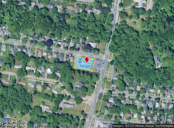
Property Record
410 Longmeadow St, Longmeadow, MA 01106

NEARBY LISTINGS FOR SALE OR LEASE
Property Detail
410 Longmeadow St
LONG-000462-000072-000008
Hampden
Regionalshoppingcenterormallwithanchorstore
Massachusetts
X
8
25013C0412E
0.59 AC
2025
Hampden County
2025
Hartford
813301
Springfield, MA
15,902 SF
DEMOGRAPHICS near 410 Longmeadow St
1 Mile
3 Mile
5 Mile
2024 Total Population
6,770
72,865
196,076
2029 Population
6,659
71,350
192,726
Pop Growth 2024-2029
(1.64%)
(2.08%)
(1.71%)
Average Age
41
40
39
2024 Total Households
2,354
28,151
74,732
HH Growth 2024-2029
(1.70%)
(2.12%)
(1.80%)
Median Household Inc
$146,615
$63,880
$56,952
Avg Household Size
2.80
2.50
2.40
2024 Avg HH Vehicles
2.00
2.00
1.00
Median Home Value
$383,743
$275,674
$248,308
Median Year Built
1948
1952
1954
Nearby Places
Map Layers
Map Styles
 Street
 Aerial
- Restaurants
- Banks
- Shops
- Fitness
- Groceries
PUBLIC TRANSPORTATION
COMMUTER RAIL
DRIVE
WALK
Distance
7 min
4.0 mi
AIRPORT
Bradley International
DRIVE
WALK
Distance
Bradley International
31 min
12.8 mi
SALE & LEASE HISTORY
LISTING DATE
SALE/LEASE

Sep 20, 2020
For Lease
Jun 11, 2021
For Lease
Jun 10, 2018
For Lease
Nearby Properties
Address
Land Use
TOTAL SIZE
Lot Size
Zoning
Address
Land Use
TOTAL SIZE
Lot Size
Zoning
236,616 SF
31.07 AC
RA1
Address
Land Use
TOTAL SIZE
Lot Size
Zoning
162,232 SF
3.06 AC
R2
Address
Land Use
TOTAL SIZE
Lot Size
Zoning
82,248 SF
4.57 AC
SR3C1
Address
Land Use
TOTAL SIZE
Lot Size
Zoning
227,072 SF
4.37 AC
B3
Address
Land Use
TOTAL SIZE
Lot Size
Zoning
75,000 SF
3.10 AC
B1
Address
Land Use
TOTAL SIZE
Lot Size
Zoning
69.62 AC
MFHD
Address
Land Use
TOTAL SIZE
Lot Size
Zoning
839,347 SF
2.05 AC
B3
Address
Land Use
TOTAL SIZE
Lot Size
Zoning
232,510 SF
61.40 AC
RB
Address
Land Use
TOTAL SIZE
Lot Size
Zoning
100,000 SF
17.80 AC
WC
Address
Land Use
TOTAL SIZE
Lot Size
Zoning
8,712 SF
25.08 AC
RA1
Address
Land Use
TOTAL SIZE
Lot Size
Zoning
42,412 SF
2.22 AC
SR2B1
Address
Land Use
TOTAL SIZE
Lot Size
Zoning
24,835 SF
2.16 AC
B3
Address
Land Use
TOTAL SIZE
Lot Size
Zoning
335,105 SF
1.28 AC
B3
Address
Land Use
TOTAL SIZE
Lot Size
Zoning
9.69 AC
B
Address
Land Use
TOTAL SIZE
Lot Size
Zoning
1,840 SF
148.78 AC
BB
Address
Land Use
TOTAL SIZE
Lot Size
Zoning
27,200 SF
13.22 AC
MULT
Address
Land Use
TOTAL SIZE
Lot Size
Zoning
84,605 SF
13.15 AC
RB
Address
Land Use
TOTAL SIZE
Lot Size
Zoning
4,400 SF
675 AC
SR1R2
Address
Land Use
TOTAL SIZE
Lot Size
Zoning
62,548 SF
10.50 AC
R1
Address
Land Use
TOTAL SIZE
Lot Size
Zoning
19,380 SF
3.30 AC
R2
Address
Land Use
TOTAL SIZE
Lot Size
Zoning
27,384 SF
1.20 AC
R3
Address
Land Use
TOTAL SIZE
Lot Size
Zoning
171,105 SF
14.21 AC
Address
Land Use
TOTAL SIZE
Lot Size
Zoning
55,881 SF
2 AC
R2
Address
Land Use
TOTAL SIZE
Lot Size
Zoning
53,298 SF
7.23 AC
PRO
Address
Land Use
TOTAL SIZE
Lot Size
Zoning
183,248 SF
4.47 AC
R4
Address
Land Use
TOTAL SIZE
Lot Size
Zoning
154,126 SF
9.27 AC
Address
Land Use
TOTAL SIZE
Lot Size
Zoning
48,012 SF
0.25 AC
R2
Address
Land Use
TOTAL SIZE
Lot Size
Zoning
80,144 SF
CR
Address
Land Use
TOTAL SIZE
Lot Size
Zoning
19,122 SF
2.30 AC
R2
Address
Land Use
TOTAL SIZE
Lot Size
Zoning
18.51 AC
BA
The World's #1 Commercial Real Estate Marketplace
Connect with us
© 2025 CoStar Group
The information above has been obtained from sources believed reliable. While we do not doubt its accuracy we have not verified it and make no guarantee, warranty or representation about it. It is your responsibility to independently confirm its accuracy and completeness. Any projections, opinions, assumptions, or estimates used are for example only and do not represent the current or future performance of the property. The value of this transaction to you depends on tax and other factors which should be evaluated by your tax, financial, and legal advisors. You and your advisors should conduct a careful, independent investigation of the property to determine to your satisfaction the suitability of the property for your needs.