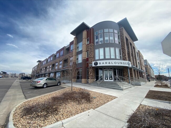
Property Record
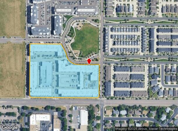
351 E Dry Creek Rd, Littleton, CO 80122
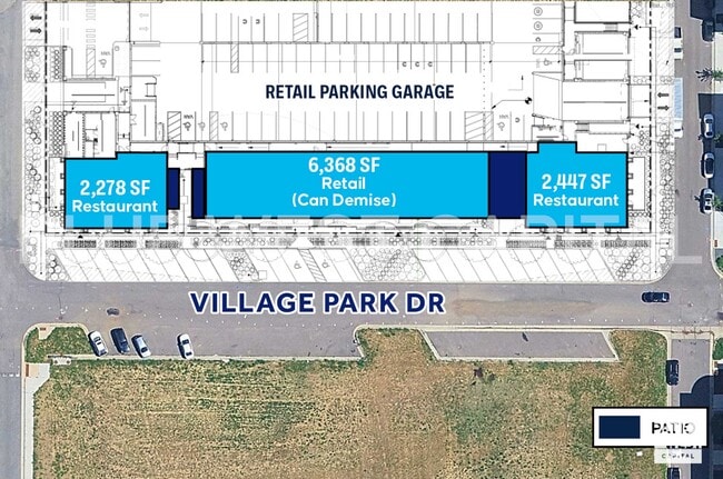
Current Lease Availabilities
NEARBY LISTINGS FOR SALE OR LEASE
Property Detail
351 E Dry Creek Rd
Denver-Aurora-Lakewood, CO
Littleton Village Replat 4
2077-27-4-51-001
TOWNSHIP 5S MAPPLATB 479 MAPPLATP 68 SUBDIVISIONCD 041384 SUBDIVISIONNAME LITTLETON VILLAGE REPLAT 4 BLOCK 001 LOT 001 LOT 1 BLK 1 LITTLETON VILLAGE REPLAT 4
Storebuilding
Arapahoe
X
Colorado
08005C0453L
1
2023
0.21 AC
2024
Littleton
005625
Denver
572,657 SF
DEMOGRAPHICS near 351 E Dry Creek Rd
1 Mile
3 Mile
5 Mile
2024 Total Population
13,168
105,648
259,508
2029 Population
13,217
110,425
272,135
Pop Growth 2024-2029
+ 0.37%
+ 4.52%
+ 4.87%
Average Age
42
43
42
2024 Total Households
5,178
43,895
102,280
HH Growth 2024-2029
+ 0.35%
+ 4.78%
+ 4.73%
Median Household Inc
$118,113
$106,307
$116,345
Avg Household Size
2.50
2.40
2.50
2024 Avg HH Vehicles
2.00
2.00
2.00
Median Home Value
$591,392
$630,365
$641,769
Median Year Built
1978
1983
1985
Nearby Places
Map Layers
Map Styles
 Street
 Aerial
- Restaurants
- Banks
- Shops
- Fitness
- Groceries
PUBLIC TRANSPORTATION
AIRPORT
Denver International
DRIVE
WALK
Distance
Denver International
46 min
35.1 mi
Freight Ports
Tulsa Port Of Catoosa
DRIVE
WALK
Distance
Tulsa Port Of Catoosa
739 min
721.1 mi
Nearby Properties
Address
Land Use
TOTAL SIZE
Lot Size
Zoning
Address
Land Use
TOTAL SIZE
Lot Size
Zoning
571,212 SF
21.49 AC
Address
Land Use
TOTAL SIZE
Lot Size
Zoning
390,078 SF
38.27 AC
Address
Land Use
TOTAL SIZE
Lot Size
Zoning
187,769 SF
16.09 AC
Address
Land Use
TOTAL SIZE
Lot Size
Zoning
622,103 SF
24.61 AC
PDU
Address
Land Use
TOTAL SIZE
Lot Size
Zoning
251,583 SF
38.03 AC
Address
Land Use
TOTAL SIZE
Lot Size
Zoning
133,908 SF
9.39 AC
LPD-C
Address
Land Use
TOTAL SIZE
Lot Size
Zoning
215,900 SF
15.32 AC
PDU
Address
Land Use
TOTAL SIZE
Lot Size
Zoning
1,639,172 SF
53.02 AC
Address
Land Use
TOTAL SIZE
Lot Size
Zoning
167,287 SF
13.65 AC
Address
Land Use
TOTAL SIZE
Lot Size
Zoning
150,767 SF
14.49 AC
PDU
Address
Land Use
TOTAL SIZE
Lot Size
Zoning
177,772 SF
16 AC
Address
Land Use
TOTAL SIZE
Lot Size
Zoning
519,330 SF
22.81 AC
PDU
Address
Land Use
TOTAL SIZE
Lot Size
Zoning
484,245 SF
18.06 AC
Address
Land Use
TOTAL SIZE
Lot Size
Zoning
163,695 SF
22.90 AC
Address
Land Use
TOTAL SIZE
Lot Size
Zoning
329,937 SF
35.07 AC
PUD
Address
Land Use
TOTAL SIZE
Lot Size
Zoning
411,924 SF
26.85 AC
LPDI
Address
Land Use
TOTAL SIZE
Lot Size
Zoning
192,108 SF
20.03 AC
Address
Land Use
TOTAL SIZE
Lot Size
Zoning
147,856 SF
5.49 AC
PDU
Address
Land Use
TOTAL SIZE
Lot Size
Zoning
312,130 SF
20.63 AC
PDU
Address
Land Use
TOTAL SIZE
Lot Size
Zoning
290,636 SF
14.54 AC
PDU
Address
Land Use
TOTAL SIZE
Lot Size
Zoning
1,036,325 SF
51.26 AC
PDU
Address
Land Use
TOTAL SIZE
Lot Size
Zoning
250,402 SF
21 AC
Address
Land Use
TOTAL SIZE
Lot Size
Zoning
179,081 SF
6.79 AC
Address
Land Use
TOTAL SIZE
Lot Size
Zoning
196,318 SF
4.50 AC
ARP
Address
Land Use
TOTAL SIZE
Lot Size
Zoning
206,632 SF
33.68 AC
Address
Land Use
TOTAL SIZE
Lot Size
Zoning
65,260 SF
11.15 AC
Address
Land Use
TOTAL SIZE
Lot Size
Zoning
61,607 SF
11.60 AC
LPD-C
Address
Land Use
TOTAL SIZE
Lot Size
Zoning
112,847 SF
8.08 AC
PDU
Address
Land Use
TOTAL SIZE
Lot Size
Zoning
463,840 SF
17.63 AC
PDU
The World's #1 Commercial Real Estate Marketplace
Connect with us
© 2025 CoStar Group
The information above has been obtained from sources believed reliable. While we do not doubt its accuracy we have not verified it and make no guarantee, warranty or representation about it. It is your responsibility to independently confirm its accuracy and completeness. Any projections, opinions, assumptions, or estimates used are for example only and do not represent the current or future performance of the property. The value of this transaction to you depends on tax and other factors which should be evaluated by your tax, financial, and legal advisors. You and your advisors should conduct a careful, independent investigation of the property to determine to your satisfaction the suitability of the property for your needs.