Property Record
40 W Brown Rd, Mesa, AZ 85201
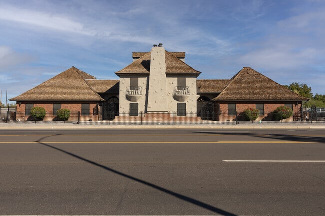


Property Detail
40 W Brown Rd
137-20-001F
W 266F OF FOL DESC PROP S 154F OF NE4 NE4 NW4 & E 6F OF S 154F OF NW4 NE4 NW4 EX N 38.50F TH/OF & EX W 60F TH/OF
Officebuilding
Maricopa
C-O
Arizona
C and X Area of minimal flood hazard, usually depicted on FIRMs as above the 500-year flood level.
0.71 AC
2025
Mesa East
2025
Phoenix
421001
Phoenix-Mesa-Chandler, AZ
9,634 SF
NEARBY LISTINGS FOR SALE OR LEASE
DEMOGRAPHICS near 40 W Brown Rd
1 mile
3 mile
5 mile
2025 Total Population
23,538
137,941
313,221
2030 Population
24,820
143,343
325,252
Pop Growth 2025-2030
+ 5.45%
+ 3.92%
+ 3.84%
Average Age
38
36
37
2025 Total Households
9,373
49,220
119,432
HH Growth 2025-2030
+ 5.81%
+ 4.11%
+ 4.05%
Median Household Inc
$60,895
$64,562
$68,745
Avg Household Size
2.40
2.70
2.50
2025 Avg HH Vehicles
2.00
2.00
2.00
Median Home Value
$388,166
$380,824
$396,589
Median Year Built
1984
1979
1981
Nearby Places
Map Layers
Map Styles
 Street
 Aerial
Transit
 Traffic
 Biking
Places
Listings with unknown addresses are not visible on the map
- Restaurants
- Banks
- Shops
- Fitness
- Groceries
PUBLIC TRANSPORTATION
AIRPORT
Phoenix Sky Harbor International
Drive
Walk
Distance
Phoenix Sky Harbor International
19 min
11.9 mi
Phoenix-Mesa Gateway
Drive
Walk
Distance
Phoenix-Mesa Gateway
31 min
18.8 mi
SALE & LEASE HISTORY
LISTING DATE
SALE/LEASE

Sep 24, 2016
For Lease
Sep 07, 2018
For Lease
Sep 06, 2017
For Lease
Oct 27, 2025
For Sale
Mar 26, 2019
For Sale
Jun 22, 2017
For Lease
Jun 05, 2017
For Lease
Dec 13, 2022
For Sale
Nearby Properties
Address
Land Use
TOTAL SIZE
Lot Size
Zoning
Address
Land Use
TOTAL SIZE
Lot Size
Zoning
8.79 AC
PF
Address
Land Use
TOTAL SIZE
Lot Size
Zoning
197,454 SF
18.97 AC
PF
Address
Land Use
TOTAL SIZE
Lot Size
Zoning
377,442 SF
0.21 AC
C-DT
Address
Land Use
TOTAL SIZE
Lot Size
Zoning
267,023 SF
19.58 AC
PEP
Address
Land Use
TOTAL SIZE
Lot Size
Zoning
485,625 SF
45.99 AC
PF
Address
Land Use
TOTAL SIZE
Lot Size
Zoning
32,619 SF
2.40 AC
C-G
Address
Land Use
TOTAL SIZE
Lot Size
Zoning
501,927 SF
8.13 AC
GC
Address
Land Use
TOTAL SIZE
Lot Size
Zoning
579,506 SF
17.78 AC
PF
Address
Land Use
TOTAL SIZE
Lot Size
Zoning
407,570 SF
6.22 AC
PEP
Address
Land Use
TOTAL SIZE
Lot Size
Zoning
454,015 SF
10.03 AC
DB1
Address
Land Use
TOTAL SIZE
Lot Size
Zoning
1.46 AC
C-G
Address
Land Use
TOTAL SIZE
Lot Size
Zoning
160,533 SF
7.59 AC
GC
Address
Land Use
TOTAL SIZE
Lot Size
Zoning
478,411 SF
4.07 AC
CDT
Address
Land Use
TOTAL SIZE
Lot Size
Zoning
210,613 SF
15.50 AC
I-1
Address
Land Use
TOTAL SIZE
Lot Size
Zoning
199,472 SF
4.79 AC
C-DT
Address
Land Use
TOTAL SIZE
Lot Size
Zoning
152,199 SF
21.96 AC
C-G
Address
Land Use
TOTAL SIZE
Lot Size
Zoning
307,038 SF
16.29 AC
M-H
Address
Land Use
TOTAL SIZE
Lot Size
Zoning
79,452 SF
37.59 AC
PF
Address
Land Use
TOTAL SIZE
Lot Size
Zoning
107,519 SF
9.96 AC
M-H
Address
Land Use
TOTAL SIZE
Lot Size
Zoning
169,128 SF
27.30 AC
R-9
Address
Land Use
TOTAL SIZE
Lot Size
Zoning
536,470 SF
28.81 AC
M-H
Address
Land Use
TOTAL SIZE
Lot Size
Zoning
205,331 SF
20.73 AC
C-G
Address
Land Use
TOTAL SIZE
Lot Size
Zoning
347,420 SF
16.94 AC
M-H
Address
Land Use
TOTAL SIZE
Lot Size
Zoning
142,260 SF
17.92 AC
PF
Address
Land Use
TOTAL SIZE
Lot Size
Zoning
305,624 SF
18.53 AC
Address
Land Use
TOTAL SIZE
Lot Size
Zoning
321,591 SF
15.68 AC
M-H
Address
Land Use
TOTAL SIZE
Lot Size
Zoning
126,164 SF
25.41 AC
C-G
Address
Land Use
TOTAL SIZE
Lot Size
Zoning
108,672 SF
1.59 AC
CDT
Address
Land Use
TOTAL SIZE
Lot Size
Zoning
65,192 SF
11.36 AC
C-G
Address
Land Use
TOTAL SIZE
Lot Size
Zoning
92,655 SF
10 AC
R-6
The World's #1 Commercial Real Estate Marketplace
Connect with us
© 2026 CoStar Group
The information above has been obtained from sources believed reliable. While we do not doubt its accuracy we have not verified it and make no guarantee, warranty or representation about it. It is your responsibility to independently confirm its accuracy and completeness. Any projections, opinions, assumptions, or estimates used are for example only and do not represent the current or future performance of the property. The value of this transaction to you depends on tax and other factors which should be evaluated by your tax, financial, and legal advisors. You and your advisors should conduct a careful, independent investigation of the property to determine to your satisfaction the suitability of the property for your needs.