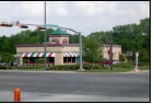
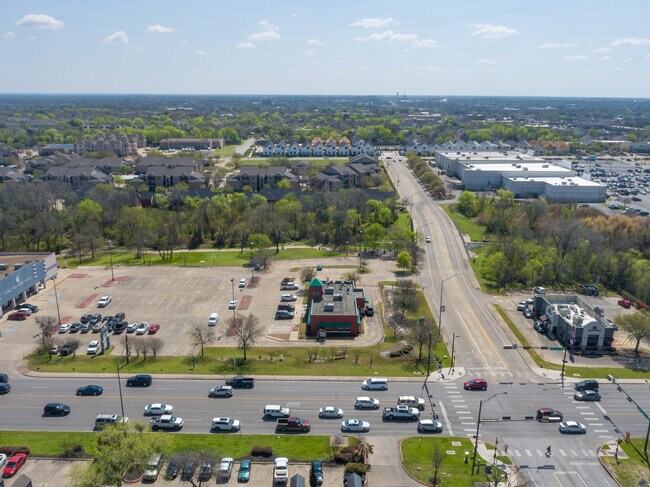
Property Record
400 Harvey Rd, College Station, TX 77840

Save to a Folder
{{folder.Name}}
{{folder.ListingIds.length}} Properties
{{folder.ListingIds.length}} Property
Create a New Folder
Property Detail
400 Harvey Rd
College Station-Bryan, TX
LACOUR PH 1, LOT 1A (LESS .0313AC OF), ACRES 1.3337
98549
Brazos
Commercialnec
Texas
B and X Area of moderate flood hazard, usually the area between the limits of the 100-year and 500-year floods.
1a
2024
1.33 AC
2025
Bryan & College Station
001703
Other Market Areas
3,564 SF
NEARBY LISTINGS FOR SALE OR LEASE
DEMOGRAPHICS near 400 Harvey Rd
1 mile
3 mile
5 mile
2025 Total Population
18,504
106,252
177,505
2030 Population
19,614
111,124
186,782
Pop Growth 2025-2030
+ 6.00%
+ 4.59%
+ 5.23%
Average Age
29
30
32
2025 Total Households
8,555
39,147
67,336
HH Growth 2025-2030
+ 6.39%
+ 5.24%
+ 5.86%
Median Household Inc
$37,743
$38,672
$47,195
Avg Household Size
2.10
2.20
2.30
2025 Avg HH Vehicles
2.00
2.00
2.00
Median Home Value
$318,828
$312,531
$296,389
Median Year Built
1988
1991
1994
Nearby Places
Map Layers
Map Styles
 Street
 Aerial
Layers
 Traffic
 Biking
Places
Listings with unknown addresses are not visible on the map
- Restaurants
- Banks
- Shops
- Fitness
- Groceries
PUBLIC TRANSPORTATION
AIRPORT
Easterwood Field
Drive
Walk
Distance
Easterwood Field
16 min
5.7 mi
Freight Ports
Port of Houston
Drive
Walk
Distance
Port of Houston
121 min
97.3 mi
SALE & LEASE HISTORY
LISTING DATE
SALE/LEASE

May 17, 2021
For Sale
Nearby Properties
Address
Land Use
TOTAL SIZE
Lot Size
Zoning
Address
Land Use
TOTAL SIZE
Lot Size
Zoning
1,260,324 SF
47.72 AC
Address
Land Use
TOTAL SIZE
Lot Size
Zoning
452,252 SF
623.10 AC
Address
Land Use
TOTAL SIZE
Lot Size
Zoning
387,358 SF
1.82 AC
Address
Land Use
TOTAL SIZE
Lot Size
Zoning
308,612 SF
2.17 AC
Address
Land Use
TOTAL SIZE
Lot Size
Zoning
Address
Land Use
TOTAL SIZE
Lot Size
Zoning
464,811 SF
2.15 AC
Address
Land Use
TOTAL SIZE
Lot Size
Zoning
527,220 SF
41.58 AC
Address
Land Use
TOTAL SIZE
Lot Size
Zoning
302,580 SF
13.83 AC
Address
Land Use
TOTAL SIZE
Lot Size
Zoning
197,038 SF
7.84 AC
Address
Land Use
TOTAL SIZE
Lot Size
Zoning
301,163 SF
3.22 AC
Address
Land Use
TOTAL SIZE
Lot Size
Zoning
360,536 SF
4.05 AC
Address
Land Use
TOTAL SIZE
Lot Size
Zoning
396,301 SF
0.94 AC
Address
Land Use
TOTAL SIZE
Lot Size
Zoning
228,117 SF
37.23 AC
Address
Land Use
TOTAL SIZE
Lot Size
Zoning
369,909 SF
29.84 AC
Address
Land Use
TOTAL SIZE
Lot Size
Zoning
503,906 SF
23.31 AC
Address
Land Use
TOTAL SIZE
Lot Size
Zoning
294,267 SF
13.80 AC
Address
Land Use
TOTAL SIZE
Lot Size
Zoning
353,843 SF
36.83 AC
Address
Land Use
TOTAL SIZE
Lot Size
Zoning
409,205 SF
26.99 AC
Address
Land Use
TOTAL SIZE
Lot Size
Zoning
320,852 SF
28.12 AC
Address
Land Use
TOTAL SIZE
Lot Size
Zoning
311,236 SF
20.24 AC
Address
Land Use
TOTAL SIZE
Lot Size
Zoning
412,292 SF
31.12 AC
Address
Land Use
TOTAL SIZE
Lot Size
Zoning
382,342 SF
40 AC
Address
Land Use
TOTAL SIZE
Lot Size
Zoning
281,500 SF
16.67 AC
Address
Land Use
TOTAL SIZE
Lot Size
Zoning
3,680 SF
48.92 AC
Address
Land Use
TOTAL SIZE
Lot Size
Zoning
299,909 SF
7.43 AC
Address
Land Use
TOTAL SIZE
Lot Size
Zoning
359,171 SF
16.98 AC
Address
Land Use
TOTAL SIZE
Lot Size
Zoning
284,699 SF
15.21 AC
Address
Land Use
TOTAL SIZE
Lot Size
Zoning
198,285 SF
3.43 AC
Address
Land Use
TOTAL SIZE
Lot Size
Zoning
298,084 SF
5.04 AC
Address
Land Use
TOTAL SIZE
Lot Size
Zoning
283,322 SF
14.78 AC
The World's #1 Commercial Real Estate Marketplace
Connect with us
© 2026 CoStar Group
The information above has been obtained from sources believed reliable. While we do not doubt its accuracy we have not verified it and make no guarantee, warranty or representation about it. It is your responsibility to independently confirm its accuracy and completeness. Any projections, opinions, assumptions, or estimates used are for example only and do not represent the current or future performance of the property. The value of this transaction to you depends on tax and other factors which should be evaluated by your tax, financial, and legal advisors. You and your advisors should conduct a careful, independent investigation of the property to determine to your satisfaction the suitability of the property for your needs.