Property Record
400 N Porter Rd, Conroe, TX 77301
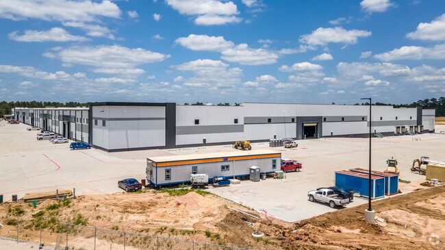

Property Detail
400 N Porter Rd
3456-00-00100
S345600 - CONROE LOGISTICS CENTER, RES A, ACRES 81.7558
Commercialnec
MONTGOMERY
B and X Area of moderate flood hazard, usually the area between the limits of the 100-year and 500-year floods.
Texas
2024
81.76 AC
2025
The Woodlands/Conroe
693902
Houston
619,770 SF
Houston-Pasadena-The Woodlands, TX
NEARBY LISTINGS FOR SALE OR LEASE
DEMOGRAPHICS near 400 N Porter Rd
1 mile
3 mile
5 mile
2025 Total Population
8,112
57,674
103,036
2030 Population
9,547
67,779
121,555
Pop Growth 2025-2030
+ 17.69%
+ 17.52%
+ 17.97%
Average Age
34
35
37
2025 Total Households
2,431
19,664
36,481
HH Growth 2025-2030
+ 18.14%
+ 18.64%
+ 18.86%
Median Household Inc
$74,446
$63,582
$73,500
Avg Household Size
3.20
2.70
2.70
2025 Avg HH Vehicles
2.00
2.00
2.00
Median Home Value
$179,236
$230,378
$301,563
Median Year Built
1996
2000
2005
Nearby Places
Map Layers
Map Styles
 Street
 Aerial
Layers
 Traffic
 Biking
Places
Listings with unknown addresses are not visible on the map
- Restaurants
- Banks
- Shops
- Fitness
- Groceries
PUBLIC TRANSPORTATION
AIRPORT
George Bush Intcntl/Houston
Drive
Walk
Distance
George Bush Intcntl/Houston
43 min
33.3 mi
Freight Ports
Port of Houston
Drive
Walk
Distance
Port of Houston
66 min
49.0 mi
Nearby Properties
Address
Land Use
TOTAL SIZE
Lot Size
Zoning
Address
Land Use
TOTAL SIZE
Lot Size
Zoning
322,082 SF
36.56 AC
1
Address
Land Use
TOTAL SIZE
Lot Size
Zoning
398,842 SF
23.75 AC
1
Address
Land Use
TOTAL SIZE
Lot Size
Zoning
354,000 SF
13.81 AC
Address
Land Use
TOTAL SIZE
Lot Size
Zoning
361,388 SF
16.32 AC
Address
Land Use
TOTAL SIZE
Lot Size
Zoning
191,700 SF
19.41 AC
1
Address
Land Use
TOTAL SIZE
Lot Size
Zoning
326,478 SF
20.22 AC
Address
Land Use
TOTAL SIZE
Lot Size
Zoning
366,709 SF
27.72 AC
Address
Land Use
TOTAL SIZE
Lot Size
Zoning
258,100 SF
12.04 AC
1
Address
Land Use
TOTAL SIZE
Lot Size
Zoning
206,008 SF
107.61 AC
Address
Land Use
TOTAL SIZE
Lot Size
Zoning
211,275 SF
12.58 AC
Address
Land Use
TOTAL SIZE
Lot Size
Zoning
191,006 SF
9.19 AC
Address
Land Use
TOTAL SIZE
Lot Size
Zoning
142,800 SF
7.82 AC
Address
Land Use
TOTAL SIZE
Lot Size
Zoning
136,300 SF
9.08 AC
1
Address
Land Use
TOTAL SIZE
Lot Size
Zoning
89,298 SF
9.22 AC
Address
Land Use
TOTAL SIZE
Lot Size
Zoning
590,471 SF
32.21 AC
Address
Land Use
TOTAL SIZE
Lot Size
Zoning
197,533 SF
58.31 AC
Address
Land Use
TOTAL SIZE
Lot Size
Zoning
175,476 SF
8.03 AC
1
Address
Land Use
TOTAL SIZE
Lot Size
Zoning
171,124 SF
9.03 AC
1
Address
Land Use
TOTAL SIZE
Lot Size
Zoning
75,048 SF
10.59 AC
Address
Land Use
TOTAL SIZE
Lot Size
Zoning
376,980 SF
24.37 AC
1
Address
Land Use
TOTAL SIZE
Lot Size
Zoning
242,944 SF
179.58 AC
Address
Land Use
TOTAL SIZE
Lot Size
Zoning
94,950 SF
7.41 AC
1
Address
Land Use
TOTAL SIZE
Lot Size
Zoning
148,906 SF
7.05 AC
1
Address
Land Use
TOTAL SIZE
Lot Size
Zoning
332,274 SF
40 AC
Address
Land Use
TOTAL SIZE
Lot Size
Zoning
205,088 SF
79.14 AC
Address
Land Use
TOTAL SIZE
Lot Size
Zoning
171,550 SF
25.36 AC
1
Address
Land Use
TOTAL SIZE
Lot Size
Zoning
221,890 SF
17.18 AC
Address
Land Use
TOTAL SIZE
Lot Size
Zoning
89,736 SF
26.85 AC
1
Address
Land Use
TOTAL SIZE
Lot Size
Zoning
121,018 SF
7.81 AC
The World's #1 Commercial Real Estate Marketplace
Connect with us
© 2026 CoStar Group
The information above has been obtained from sources believed reliable. While we do not doubt its accuracy we have not verified it and make no guarantee, warranty or representation about it. It is your responsibility to independently confirm its accuracy and completeness. Any projections, opinions, assumptions, or estimates used are for example only and do not represent the current or future performance of the property. The value of this transaction to you depends on tax and other factors which should be evaluated by your tax, financial, and legal advisors. You and your advisors should conduct a careful, independent investigation of the property to determine to your satisfaction the suitability of the property for your needs.