Property Record
401 Massachusetts Ave, Acton, MA 01720
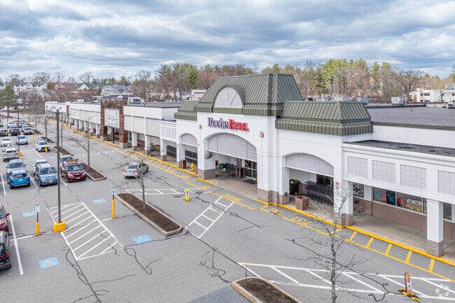
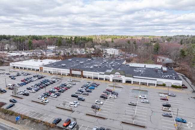
Property Detail
401 Massachusetts Ave
ACTO-000003F-000097-000001
MIDDLESEX
Regionalshoppingcenterormallwithanchorstore
Massachusetts
KC
1
B and X Area of moderate flood hazard, usually the area between the limits of the 100-year and 500-year floods.
0.56 AC
2025
Concord/Maynard
2025
Boston
363103
Boston-Cambridge-Newton, MA-NH
NEARBY LISTINGS FOR SALE OR LEASE
DEMOGRAPHICS near 401 Massachusetts Ave
1 mile
3 mile
5 mile
2025 Total Population
3,841
34,326
72,148
2030 Population
3,960
35,781
75,355
Pop Growth 2025-2030
+ 3.10%
+ 4.24%
+ 4.45%
Average Age
41
43
43
2025 Total Households
1,332
13,001
27,568
HH Growth 2025-2030
+ 3.23%
+ 4.37%
+ 4.59%
Median Household Inc
$187,595
$155,872
$163,537
Avg Household Size
2.80
2.60
2.60
2025 Avg HH Vehicles
2.00
2.00
2.00
Median Home Value
$794,002
$758,801
$779,584
Median Year Built
1970
1973
1974
Nearby Places
Map Layers
Map Styles
 Street
 Aerial
Layers
 Traffic
 Biking
Places
Listings with unknown addresses are not visible on the map
- Restaurants
- Banks
- Shops
- Fitness
- Groceries
PUBLIC TRANSPORTATION
COMMUTER RAIL
South Acton (Fitchburg/South Acton Line - Massachusetts Bay Transportation Authority Commuter Rail (Purple Line))
Drive
Walk
Distance
South Acton (Fitchburg/South Acton Line - Massachusetts Bay Transportation Authority Commuter Rail (Purple Line))
4 min
1.4 mi
West Concord (Fitchburg/South Acton Line - Massachusetts Bay Transportation Authority Commuter Rail (Purple Line))
Drive
Walk
Distance
West Concord (Fitchburg/South Acton Line - Massachusetts Bay Transportation Authority Commuter Rail (Purple Line))
8 min
3.7 mi
AIRPORT
General Edward Lawrence Logan International
Drive
Walk
Distance
General Edward Lawrence Logan International
44 min
27.0 mi
Worcester Regional
Drive
Walk
Distance
Worcester Regional
49 min
33.4 mi
Freight Ports
Port of Boston
Drive
Walk
Distance
Port of Boston
43 min
27.0 mi
SALE & LEASE HISTORY
LISTING DATE
SALE/LEASE

Sep 11, 2018
For Lease
Jul 07, 2017
For Lease
Feb 18, 2021
For Lease
Feb 12, 2020
For Lease
Aug 23, 2024
For Lease
Nearby Properties
Address
Land Use
TOTAL SIZE
Lot Size
Zoning
Address
Land Use
TOTAL SIZE
Lot Size
Zoning
30.39 AC
I
Address
Land Use
TOTAL SIZE
Lot Size
Zoning
197,727 SF
31.55 AC
R2
Address
Land Use
TOTAL SIZE
Lot Size
Zoning
22,927 SF
51 AC
IPA
Address
Land Use
TOTAL SIZE
Lot Size
Zoning
263,589 SF
8.76 AC
R2
Address
Land Use
TOTAL SIZE
Lot Size
Zoning
25.15 AC
R2
Address
Land Use
TOTAL SIZE
Lot Size
Zoning
7.88 AC
B
Address
Land Use
TOTAL SIZE
Lot Size
Zoning
180,143 SF
41.70 AC
OP
Address
Land Use
TOTAL SIZE
Lot Size
Zoning
20,498 SF
25.75 AC
GI
Address
Land Use
TOTAL SIZE
Lot Size
Zoning
9.56 AC
PM
Address
Land Use
TOTAL SIZE
Lot Size
Zoning
10.34 AC
LB
Address
Land Use
TOTAL SIZE
Lot Size
Zoning
131,607 SF
36.01 AC
Address
Land Use
TOTAL SIZE
Lot Size
Zoning
150,515 SF
36.95 AC
OP
Address
Land Use
TOTAL SIZE
Lot Size
Zoning
105,036 SF
6.84 AC
KC
Address
Land Use
TOTAL SIZE
Lot Size
Zoning
39,250 SF
0.39 AC
R2
Address
Land Use
TOTAL SIZE
Lot Size
Zoning
55.50 AC
ARC
Address
Land Use
TOTAL SIZE
Lot Size
Zoning
76,623 SF
16.59 AC
R2
Address
Land Use
TOTAL SIZE
Lot Size
Zoning
63.75 AC
A
Address
Land Use
TOTAL SIZE
Lot Size
Zoning
40 AC
R2
Address
Land Use
TOTAL SIZE
Lot Size
Zoning
71,395 SF
8.37 AC
C
Address
Land Use
TOTAL SIZE
Lot Size
Zoning
38,552 SF
5.34 AC
LB
Address
Land Use
TOTAL SIZE
Lot Size
Zoning
78,564 SF
3.43 AC
LB
Address
Land Use
TOTAL SIZE
Lot Size
Zoning
26.16 AC
R2
Address
Land Use
TOTAL SIZE
Lot Size
Zoning
948 AC
AR
Address
Land Use
TOTAL SIZE
Lot Size
Zoning
56,036 SF
17.13 AC
R2
Address
Land Use
TOTAL SIZE
Lot Size
Zoning
40.44 AC
ARC
Address
Land Use
TOTAL SIZE
Lot Size
Zoning
78,722 SF
7.54 AC
LB
Address
Land Use
TOTAL SIZE
Lot Size
Zoning
105,163 SF
10.65 AC
OP2
Address
Land Use
TOTAL SIZE
Lot Size
Zoning
3.85 AC
RA
Address
Land Use
TOTAL SIZE
Lot Size
Zoning
98,750 SF
15.48 AC
OP2
Address
Land Use
TOTAL SIZE
Lot Size
Zoning
33 AC
R20
The World's #1 Commercial Real Estate Marketplace
Connect with us
© 2026 CoStar Group
The information above has been obtained from sources believed reliable. While we do not doubt its accuracy we have not verified it and make no guarantee, warranty or representation about it. It is your responsibility to independently confirm its accuracy and completeness. Any projections, opinions, assumptions, or estimates used are for example only and do not represent the current or future performance of the property. The value of this transaction to you depends on tax and other factors which should be evaluated by your tax, financial, and legal advisors. You and your advisors should conduct a careful, independent investigation of the property to determine to your satisfaction the suitability of the property for your needs.