Property Record
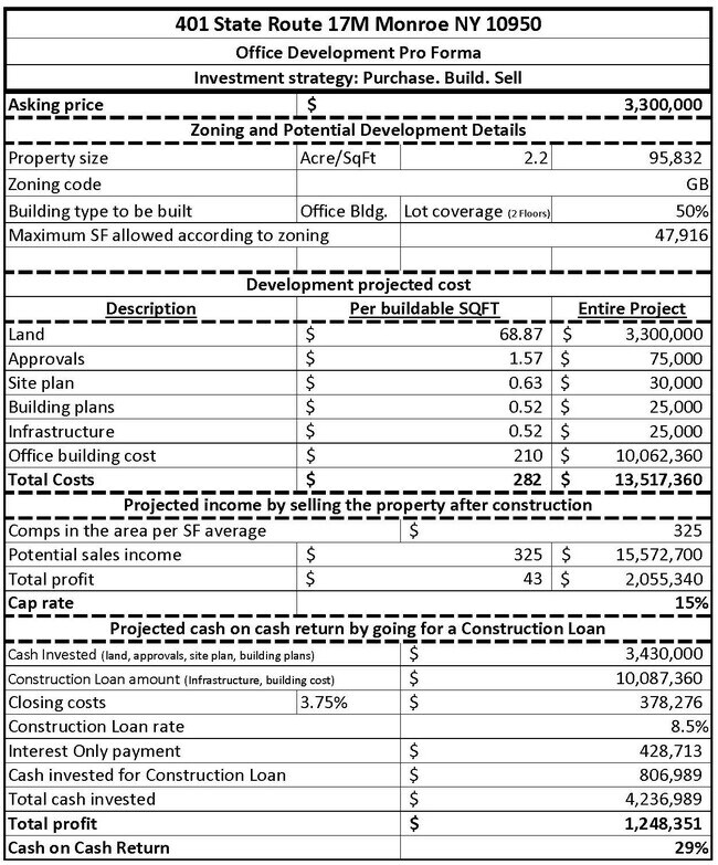
401 State Route 17M, Monroe, NY 10950
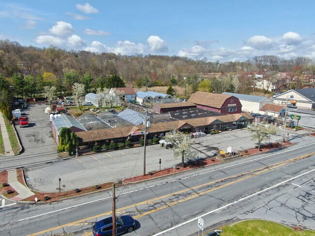

Property Detail
401 State Route 17M
334001-223-000-0001-005.100-0000
Orange
Horticulturegrowinghousesagricultural
New York
GB
5.100
AE The base floodplain where base flood elevations are provided. AE Zones are now used on new format FIRMs instead of A1-A30 Zones.
2.18 AC
2024
Monroe
2025
Northern New Jersey
014101
Kiryas Joel-Poughkeepsie-Newburgh, NY
8,438 SF
NEARBY LISTINGS FOR SALE OR LEASE
DEMOGRAPHICS near 401 State Route 17M
1 mile
3 mile
5 mile
2025 Total Population
8,127
63,062
82,606
2030 Population
8,257
65,056
85,005
Pop Growth 2025-2030
+ 1.60%
+ 3.16%
+ 2.90%
Average Age
37
29
31
2025 Total Households
2,707
15,187
21,234
HH Growth 2025-2030
+ 1.44%
+ 3.34%
+ 2.97%
Median Household Inc
$104,644
$80,796
$91,263
Avg Household Size
3.00
4.00
3.70
2025 Avg HH Vehicles
2.00
1.00
2.00
Median Home Value
$413,985
$548,215
$494,193
Median Year Built
1982
1993
1988
Nearby Places
Map Layers
Map Styles
 Street
 Aerial
Layers
 Traffic
 Biking
Places
Listings with unknown addresses are not visible on the map
- Restaurants
- Banks
- Shops
- Fitness
- Groceries
PUBLIC TRANSPORTATION
COMMUTER RAIL
Harriman (Bergen County/Port Jervis Line - NJ Transit Commuter Rail (NJ Transit), Main/Port Jervis Line - NJ Transit Commuter Rail (NJ Transit))
Drive
Walk
Distance
Harriman (Bergen County/Port Jervis Line - NJ Transit Commuter Rail (NJ Transit), Main/Port Jervis Line - NJ Transit Commuter Rail (NJ Transit))
5 min
2.6 mi
AIRPORT
New York Stewart International
Drive
Walk
Distance
New York Stewart International
31 min
17.0 mi
Westchester County
Drive
Walk
Distance
Westchester County
62 min
46.2 mi
Freight Ports
Port Newark Container Terminal
Drive
Walk
Distance
Port Newark Container Terminal
75 min
54.0 mi
SALE & LEASE HISTORY
LISTING DATE
SALE/LEASE

Mar 20, 2023
For Sale
Aug 21, 2017
For Lease
Nearby Properties
Address
Land Use
TOTAL SIZE
Lot Size
Zoning
Address
Land Use
TOTAL SIZE
Lot Size
Zoning
143.60 AC
LIO
Address
Land Use
TOTAL SIZE
Lot Size
Zoning
114.40 AC
Address
Land Use
TOTAL SIZE
Lot Size
Zoning
12 AC
Address
Land Use
TOTAL SIZE
Lot Size
Zoning
235,455 SF
51.70 AC
IB
Address
Land Use
TOTAL SIZE
Lot Size
Zoning
103,290 SF
41.22 AC
RR-1.0AC
Address
Land Use
TOTAL SIZE
Lot Size
Zoning
125,636 SF
19.91 AC
SR-20
Address
Land Use
TOTAL SIZE
Lot Size
Zoning
Address
Land Use
TOTAL SIZE
Lot Size
Zoning
7.30 AC
LIO
Address
Land Use
TOTAL SIZE
Lot Size
Zoning
31,507 SF
10.50 AC
UR-M
Address
Land Use
TOTAL SIZE
Lot Size
Zoning
31,507 SF
10.50 AC
UR-M
Address
Land Use
TOTAL SIZE
Lot Size
Zoning
8 AC
PD
Address
Land Use
TOTAL SIZE
Lot Size
Zoning
4.50 AC
Address
Land Use
TOTAL SIZE
Lot Size
Zoning
7.50 AC
RQTRA
Address
Land Use
TOTAL SIZE
Lot Size
Zoning
9.60 AC
IB
Address
Land Use
TOTAL SIZE
Lot Size
Zoning
15.90 AC
Address
Land Use
TOTAL SIZE
Lot Size
Zoning
6.90 AC
Address
Land Use
TOTAL SIZE
Lot Size
Zoning
28,934 SF
6.60 AC
PD
Address
Land Use
TOTAL SIZE
Lot Size
Zoning
39,235 SF
6.40 AC
Address
Land Use
TOTAL SIZE
Lot Size
Zoning
124,928 SF
12.14 AC
GB
Address
Land Use
TOTAL SIZE
Lot Size
Zoning
70,760 SF
17.20 AC
GB
Address
Land Use
TOTAL SIZE
Lot Size
Zoning
91,472 SF
6.42 AC
SR-10
Address
Land Use
TOTAL SIZE
Lot Size
Zoning
88,240 SF
3.02 AC
R-1
Address
Land Use
TOTAL SIZE
Lot Size
Zoning
113,910 SF
15 AC
PD
Address
Land Use
TOTAL SIZE
Lot Size
Zoning
159,857 SF
24.59 AC
LI
Address
Land Use
TOTAL SIZE
Lot Size
Zoning
Address
Land Use
TOTAL SIZE
Lot Size
Zoning
103,908 SF
7.40 AC
I
Address
Land Use
TOTAL SIZE
Lot Size
Zoning
92,868 SF
1.22 AC
PD
Address
Land Use
TOTAL SIZE
Lot Size
Zoning
98,426 SF
5 AC
PD
Address
Land Use
TOTAL SIZE
Lot Size
Zoning
7.60 AC
Address
Land Use
TOTAL SIZE
Lot Size
Zoning
5.20 AC
IB
The World's #1 Commercial Real Estate Marketplace
Connect with us
© 2026 CoStar Group
The information above has been obtained from sources believed reliable. While we do not doubt its accuracy we have not verified it and make no guarantee, warranty or representation about it. It is your responsibility to independently confirm its accuracy and completeness. Any projections, opinions, assumptions, or estimates used are for example only and do not represent the current or future performance of the property. The value of this transaction to you depends on tax and other factors which should be evaluated by your tax, financial, and legal advisors. You and your advisors should conduct a careful, independent investigation of the property to determine to your satisfaction the suitability of the property for your needs.