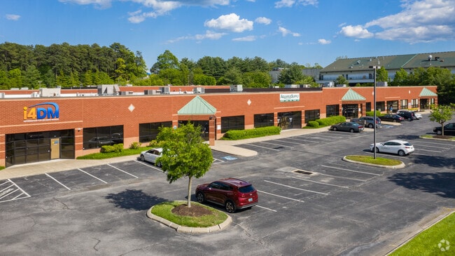
Property Record
4011 Curled Dock Ln, Odenton, MD 21113

Save to a Folder
{{folder.Name}}
{{folder.ListingIds.length}} Properties
{{folder.ListingIds.length}} Property
Create a New Folder
This Property Is For Sale
Current Lease Availabilities
Property Detail
4011 Curled Dock Ln
03-207-90084677
LT2AR U7 BLD 4 PH 1 CLOVERLEAF II
Commercialnec
Anne Arundel
C4
Maryland
B and X Area of moderate flood hazard, usually the area between the limits of the 100-year and 500-year floods.
2ar
2024
0.25 AC
2025
I-97/Crain Hwy Corrid
730601
Baltimore
11,052 SF
Baltimore-Columbia-Towson, MD
NEARBY LISTINGS FOR SALE OR LEASE
DEMOGRAPHICS near 4011 Curled Dock Ln
1 mile
3 mile
5 mile
2025 Total Population
14,680
78,364
192,832
2030 Population
14,793
78,888
194,330
Pop Growth 2025-2030
+ 0.77%
+ 0.67%
+ 0.78%
Average Age
37
39
39
2025 Total Households
5,705
29,402
70,674
HH Growth 2025-2030
+ 0.79%
+ 0.74%
+ 0.82%
Median Household Inc
$87,933
$100,349
$108,192
Avg Household Size
2.50
2.60
2.60
2025 Avg HH Vehicles
2.00
2.00
2.00
Median Home Value
$368,785
$419,121
$423,412
Median Year Built
1981
1978
1983
Nearby Places
Map Layers
Map Styles
 Street
 Aerial
Layers
 Traffic
 Biking
Places
Listings with unknown addresses are not visible on the map
- Restaurants
- Banks
- Shops
- Fitness
- Groceries
PUBLIC TRANSPORTATION
COMMUTER RAIL
Odenton (PENN - WASHINGTON - Maryland Area Regional Commuter Trains (The MARC), Penn Line - Maryland Area Regional Commuter Trains (The MARC))
Drive
Walk
Distance
Odenton (PENN - WASHINGTON - Maryland Area Regional Commuter Trains (The MARC), Penn Line - Maryland Area Regional Commuter Trains (The MARC))
20 min
7.4 mi
AIRPORT
Baltimore/Washington International Thurgood Marshall
Drive
Walk
Distance
Baltimore/Washington International Thurgood Marshall
35 min
15.7 mi
Ronald Reagan Washington Ntl
Drive
Walk
Distance
Ronald Reagan Washington Ntl
49 min
30.4 mi
Freight Ports
Port of Baltimore
Drive
Walk
Distance
Port of Baltimore
42 min
25.1 mi
Nearby Properties
Address
Land Use
TOTAL SIZE
Lot Size
Zoning
Address
Land Use
TOTAL SIZE
Lot Size
Zoning
444,842 SF
19.48 AC
R22
Address
Land Use
TOTAL SIZE
Lot Size
Zoning
360,354 SF
7.36 AC
MXD-C
Address
Land Use
TOTAL SIZE
Lot Size
Zoning
246,000 SF
15.73 AC
MXDR
Address
Land Use
TOTAL SIZE
Lot Size
Zoning
273,816 SF
44.22 AC
MXD-C
Address
Land Use
TOTAL SIZE
Lot Size
Zoning
80,321 SF
11.78 AC
CGO
Address
Land Use
TOTAL SIZE
Lot Size
Zoning
227.10 AC
NAC
Address
Land Use
TOTAL SIZE
Lot Size
Zoning
287,439 SF
19.97 AC
CGO
Address
Land Use
TOTAL SIZE
Lot Size
Zoning
8.70 AC
R15
Address
Land Use
TOTAL SIZE
Lot Size
Zoning
237,377 SF
9.86 AC
R15
Address
Land Use
TOTAL SIZE
Lot Size
Zoning
159,944 SF
5.34 AC
C1
Address
Land Use
TOTAL SIZE
Lot Size
Zoning
101,475 SF
11.17 AC
CGO
Address
Land Use
TOTAL SIZE
Lot Size
Zoning
8.38 AC
R22
Address
Land Use
TOTAL SIZE
Lot Size
Zoning
108,480 SF
17.66 AC
C4
Address
Land Use
TOTAL SIZE
Lot Size
Zoning
72,925 SF
4.12 AC
MXR
Address
Land Use
TOTAL SIZE
Lot Size
Zoning
102,545 SF
10.79 AC
CGO
Address
Land Use
TOTAL SIZE
Lot Size
Zoning
47,744 SF
1.79 AC
MXD-C
Address
Land Use
TOTAL SIZE
Lot Size
Zoning
39,695 SF
11.66 AC
C4
Address
Land Use
TOTAL SIZE
Lot Size
Zoning
134,923 SF
8.35 AC
MXD-C
Address
Land Use
TOTAL SIZE
Lot Size
Zoning
86,496 SF
6.86 AC
R5
Address
Land Use
TOTAL SIZE
Lot Size
Zoning
87,919 SF
9.71 AC
R5
Address
Land Use
TOTAL SIZE
Lot Size
Zoning
112,028 SF
40.41 AC
R1
Address
Land Use
TOTAL SIZE
Lot Size
Zoning
63,000 SF
22.90 AC
R1
Address
Land Use
TOTAL SIZE
Lot Size
Zoning
29,161 SF
3.98 AC
MXD-C
Address
Land Use
TOTAL SIZE
Lot Size
Zoning
91,592 SF
9.51 AC
C3
Address
Land Use
TOTAL SIZE
Lot Size
Zoning
78,930 SF
9.24 AC
R5
Address
Land Use
TOTAL SIZE
Lot Size
Zoning
74,054 SF
1.40 AC
R1
Address
Land Use
TOTAL SIZE
Lot Size
Zoning
168,332 SF
20.65 AC
C3
Address
Land Use
TOTAL SIZE
Lot Size
Zoning
48,979 SF
1.64 AC
R1
Address
Land Use
TOTAL SIZE
Lot Size
Zoning
61,154 SF
5.06 AC
MXD-C
The World's #1 Commercial Real Estate Marketplace
Connect with us
© 2026 CoStar Group
The information above has been obtained from sources believed reliable. While we do not doubt its accuracy we have not verified it and make no guarantee, warranty or representation about it. It is your responsibility to independently confirm its accuracy and completeness. Any projections, opinions, assumptions, or estimates used are for example only and do not represent the current or future performance of the property. The value of this transaction to you depends on tax and other factors which should be evaluated by your tax, financial, and legal advisors. You and your advisors should conduct a careful, independent investigation of the property to determine to your satisfaction the suitability of the property for your needs.