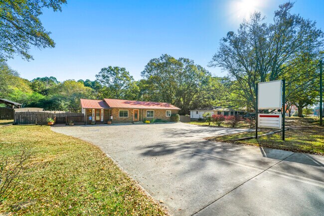
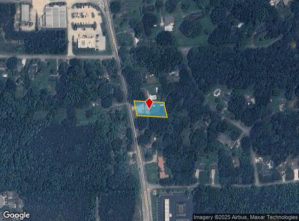
Property Record
402 Carrollton St, Temple, GA 30179

NEARBY LISTINGS FOR SALE OR LEASE
-
-
View all Temple listings for sale on LoopNet.com
Property Detail
402 Carrollton St
T04-0060032
COMM BLDG/.44AC 402 CARROLLTON ST T31
Commercialnec
Carroll
X
Georgia
13143C0260B
0.44 AC
2025
Villa Rica/W Outlying
2025
Atlanta
910202
Atlanta-Sandy Springs-Roswell, GA
1,576 SF
DEMOGRAPHICS near 402 Carrollton St
1 mile
3 mile
5 mile
2024 Total Population
2,810
11,892
24,084
2029 Population
3,156
13,338
26,819
Pop Growth 2024-2029
+ 12.31%
+ 12.16%
+ 11.36%
Average Age
36
37
37
2024 Total Households
948
4,100
8,410
HH Growth 2024-2029
+ 12.45%
+ 12.24%
+ 11.46%
Median Household Inc
$73,865
$68,661
$66,900
Avg Household Size
2.90
2.90
2.80
2024 Avg HH Vehicles
2.00
2.00
2.00
Median Home Value
$187,729
$200,309
$211,269
Median Year Built
1998
1997
1995
Nearby Places
Map Layers
Map Styles
 Street
 Aerial
Transit
 Traffic
 Biking
Places
Listings with unknown addresses are not visible on the map
- Restaurants
- Banks
- Shops
- Fitness
- Groceries
SALE & LEASE HISTORY
LISTING DATE
SALE/LEASE

Nov 12, 2023
For Sale
May 01, 2025
For Sale
Nearby Properties
Address
Land Use
TOTAL SIZE
Lot Size
Zoning
Address
Land Use
TOTAL SIZE
Lot Size
Zoning
228,640 SF
17.27 AC
I
Address
Land Use
TOTAL SIZE
Lot Size
Zoning
280,118 SF
22.72 AC
I
Address
Land Use
TOTAL SIZE
Lot Size
Zoning
83,083 SF
11.21 AC
GC
Address
Land Use
TOTAL SIZE
Lot Size
Zoning
138,953 SF
18.97 AC
RD
Address
Land Use
TOTAL SIZE
Lot Size
Zoning
25,562 SF
7.81 AC
R14
Address
Land Use
TOTAL SIZE
Lot Size
Zoning
102,856 SF
13.13 AC
I
Address
Land Use
TOTAL SIZE
Lot Size
Zoning
17,182 SF
27.39 AC
GC
Address
Land Use
TOTAL SIZE
Lot Size
Zoning
138.26 AC
A
Address
Land Use
TOTAL SIZE
Lot Size
Zoning
24,904 SF
9.93 AC
GC
Address
Land Use
TOTAL SIZE
Lot Size
Zoning
86,167 SF
6.90 AC
RD
Address
Land Use
TOTAL SIZE
Lot Size
Zoning
36,322 SF
101.77 AC
A
Address
Land Use
TOTAL SIZE
Lot Size
Zoning
37,169 SF
3.18 AC
I
Address
Land Use
TOTAL SIZE
Lot Size
Zoning
10,142 SF
15.49 AC
A
Address
Land Use
TOTAL SIZE
Lot Size
Zoning
14,520 SF
17.31 AC
A
Address
Land Use
TOTAL SIZE
Lot Size
Zoning
3,096 SF
6.86 AC
GC
Address
Land Use
TOTAL SIZE
Lot Size
Zoning
2,220 SF
8.88 AC
C
Address
Land Use
TOTAL SIZE
Lot Size
Zoning
15.18 AC
001
Address
Land Use
TOTAL SIZE
Lot Size
Zoning
10,532 SF
8.75 AC
AG
Address
Land Use
TOTAL SIZE
Lot Size
Zoning
4,345 SF
1.75 AC
GC
Address
Land Use
TOTAL SIZE
Lot Size
Zoning
67.54 AC
A
Address
Land Use
TOTAL SIZE
Lot Size
Zoning
65.39 AC
A
Address
Land Use
TOTAL SIZE
Lot Size
Zoning
10,222 SF
19.66 AC
AG
Address
Land Use
TOTAL SIZE
Lot Size
Zoning
4,328 SF
5.76 AC
C
Address
Land Use
TOTAL SIZE
Lot Size
Zoning
13,614 SF
2.24 AC
R14
Address
Land Use
TOTAL SIZE
Lot Size
Zoning
27,834 SF
15.28 AC
001
Address
Land Use
TOTAL SIZE
Lot Size
Zoning
53.40 AC
A
Address
Land Use
TOTAL SIZE
Lot Size
Zoning
4,098 SF
1.06 AC
GC
Address
Land Use
TOTAL SIZE
Lot Size
Zoning
10,584 SF
2.99 AC
DCD
Address
Land Use
TOTAL SIZE
Lot Size
Zoning
17,500 SF
8.93 AC
I
Address
Land Use
TOTAL SIZE
Lot Size
Zoning
27,150 SF
3.71 AC
LI
The World's #1 Commercial Real Estate Marketplace
Connect with us
© 2026 CoStar Group
The information above has been obtained from sources believed reliable. While we do not doubt its accuracy we have not verified it and make no guarantee, warranty or representation about it. It is your responsibility to independently confirm its accuracy and completeness. Any projections, opinions, assumptions, or estimates used are for example only and do not represent the current or future performance of the property. The value of this transaction to you depends on tax and other factors which should be evaluated by your tax, financial, and legal advisors. You and your advisors should conduct a careful, independent investigation of the property to determine to your satisfaction the suitability of the property for your needs.