Property Record
405 Mayfield Rd, Warrenton, GA 30828
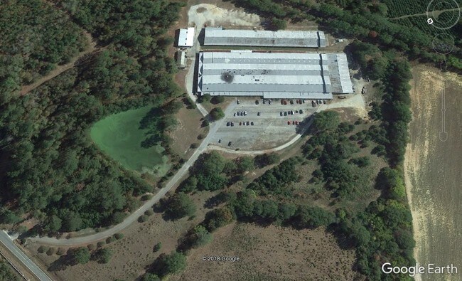

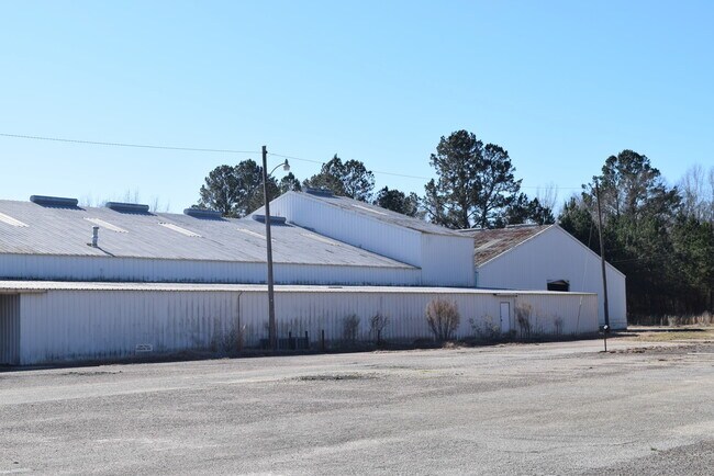
This Property Is For Sale
Current Lease Availabilities
Property Detail
405 Mayfield Rd
Industrialgeneral
26.44 AC S/S MAYFLD RD IN CITY
RESIDENTIA
Warren
B and X Area of moderate flood hazard, usually the area between the limits of the 100-year and 500-year floods.
Georgia
2025
26.44 AC
2025
Georgia Northeast
970400
Other Market Areas
121,120 SF
049-006W
NEARBY LISTINGS FOR SALE OR LEASE
DEMOGRAPHICS near 405 Mayfield Rd
1 mile
3 mile
5 mile
2025 Total Population
739
2,210
3,362
2030 Population
726
2,174
3,326
Pop Growth 2025-2030
(1.76%)
(1.63%)
(1.07%)
Average Age
42
42
44
2025 Total Households
294
892
1,380
HH Growth 2025-2030
(2.04%)
(1.57%)
(1.01%)
Median Household Inc
$33,944
$33,830
$41,818
Avg Household Size
2.40
2.40
2.40
2025 Avg HH Vehicles
2.00
2.00
2.00
Median Home Value
$87,634
$80,744
$81,817
Median Year Built
1976
1976
1978
Nearby Places
Map Layers
Map Styles
 Street
 Aerial
Layers
 Traffic
 Biking
Places
Listings with unknown addresses are not visible on the map
- Restaurants
- Banks
- Shops
- Fitness
- Groceries
Nearby Properties
Address
Land Use
TOTAL SIZE
Lot Size
Zoning
Address
Land Use
TOTAL SIZE
Lot Size
Zoning
12,000 SF
103.26 AC
INDUSTRIAL
Address
Land Use
TOTAL SIZE
Lot Size
Zoning
2,743 SF
13.59 AC
UNZONED SM
Address
Land Use
TOTAL SIZE
Lot Size
Zoning
5,382 SF
45.85 AC
INDUSTRIAL
Address
Land Use
TOTAL SIZE
Lot Size
Zoning
4 AC
UNZONED SM
Address
Land Use
TOTAL SIZE
Lot Size
Zoning
673.63 AC
UNZONED RU
Address
Land Use
TOTAL SIZE
Lot Size
Zoning
43,750 SF
10.78 AC
INDUSTRIAL
Address
Land Use
TOTAL SIZE
Lot Size
Zoning
26,849 SF
4.79 AC
RESIDENTIA
Address
Land Use
TOTAL SIZE
Lot Size
Zoning
1,278 SF
439.04 AC
UNZONED RU
Address
Land Use
TOTAL SIZE
Lot Size
Zoning
689.91 AC
UNZONED RU
Address
Land Use
TOTAL SIZE
Lot Size
Zoning
14,420 SF
5 AC
COMMERCIAL
Address
Land Use
TOTAL SIZE
Lot Size
Zoning
5,600 SF
49.08 AC
INDUSTRIAL
Address
Land Use
TOTAL SIZE
Lot Size
Zoning
11,000 SF
2.22 AC
RESIDENTIA
Address
Land Use
TOTAL SIZE
Lot Size
Zoning
22,400 SF
4.70 AC
COMMERCIAL
Address
Land Use
TOTAL SIZE
Lot Size
Zoning
605 SF
2.78 AC
COMMERCIAL
Address
Land Use
TOTAL SIZE
Lot Size
Zoning
355.74 AC
UNZONED RU
Address
Land Use
TOTAL SIZE
Lot Size
Zoning
362.55 AC
UNZONED RU
Address
Land Use
TOTAL SIZE
Lot Size
Zoning
12,504 SF
3.21 AC
COMMERCIAL
Address
Land Use
TOTAL SIZE
Lot Size
Zoning
4,821 SF
2.81 AC
COMMERCIAL
Address
Land Use
TOTAL SIZE
Lot Size
Zoning
13,900 SF
1.16 AC
RESIDENTIA
Address
Land Use
TOTAL SIZE
Lot Size
Zoning
211.04 AC
UNZONED RU
Address
Land Use
TOTAL SIZE
Lot Size
Zoning
74,850 SF
8.73 AC
INDUSTRIAL
Address
Land Use
TOTAL SIZE
Lot Size
Zoning
5,015 SF
3.28 AC
UNZONED SM
Address
Land Use
TOTAL SIZE
Lot Size
Zoning
8,000 SF
13.52 AC
INDUSTRIAL
Address
Land Use
TOTAL SIZE
Lot Size
Zoning
151.59 AC
UNZONED RU
Address
Land Use
TOTAL SIZE
Lot Size
Zoning
8,208 SF
1.44 AC
COMMERCIAL
Address
Land Use
TOTAL SIZE
Lot Size
Zoning
3,756 SF
125.16 AC
COMMERCIAL
Address
Land Use
TOTAL SIZE
Lot Size
Zoning
10,230 SF
1.09 AC
RESIDENTIA
Address
Land Use
TOTAL SIZE
Lot Size
Zoning
136.49 AC
RURAL
Address
Land Use
TOTAL SIZE
Lot Size
Zoning
132.69 AC
UNZONED RU
The World's #1 Commercial Real Estate Marketplace
Connect with us
© 2026 CoStar Group
The information above has been obtained from sources believed reliable. While we do not doubt its accuracy we have not verified it and make no guarantee, warranty or representation about it. It is your responsibility to independently confirm its accuracy and completeness. Any projections, opinions, assumptions, or estimates used are for example only and do not represent the current or future performance of the property. The value of this transaction to you depends on tax and other factors which should be evaluated by your tax, financial, and legal advisors. You and your advisors should conduct a careful, independent investigation of the property to determine to your satisfaction the suitability of the property for your needs.