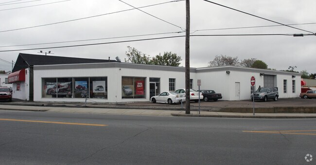
Property Record
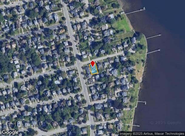
407 Taunton Ave, East Providence, RI 02914
NEARBY LISTINGS FOR SALE OR LEASE
Property Detail
407 Taunton Ave
EPRO-000306-000009-000008-000010
Providence
Commercialnec
Rhode Island
X
8
44007C0328J
1.96 AC
2025
East Providence
2025
Providence
010400
Providence-Warwick, RI-MA
2,788 SF
DEMOGRAPHICS near 407 Taunton Ave
1 Mile
3 Mile
5 Mile
2024 Total Population
14,671
104,221
358,045
2029 Population
14,469
103,959
354,426
Pop Growth 2024-2029
(1.38%)
(0.25%)
(1.01%)
Average Age
42
39
38
2024 Total Households
6,328
42,879
141,699
HH Growth 2024-2029
(1.44%)
(0.02%)
(0.96%)
Median Household Inc
$50,535
$67,944
$62,097
Avg Household Size
2.20
2.10
2.40
2024 Avg HH Vehicles
2.00
1.00
1.00
Median Home Value
$269,700
$361,319
$293,930
Median Year Built
1948
1950
1948
Nearby Places
Map Layers
Map Styles
 Street
 Aerial
- Restaurants
- Banks
- Shops
- Fitness
- Groceries
PUBLIC TRANSPORTATION
COMMUTER RAIL
Providence (Providence/Stoughton Line - Massachusetts Bay Transportation Authority Commuter Rail (Purple Line))
DRIVE
WALK
Distance
Providence (Providence/Stoughton Line - Massachusetts Bay Transportation Authority Commuter Rail (Purple Line))
8 min
4.2 mi
Tf Green Airport (Providence/Stoughton Line - MBTA)
DRIVE
WALK
Distance
Tf Green Airport (Providence/Stoughton Line - MBTA)
11 min
5.1 mi
AIRPORT
Rhode Island Tf Green International
DRIVE
WALK
Distance
Rhode Island Tf Green International
11 min
4.9 mi
Freight Ports
Port of Davisville, RI
DRIVE
WALK
Distance
Port of Davisville, RI
33 min
19.1 mi
Nearby Properties
Address
Land Use
TOTAL SIZE
Lot Size
Zoning
Address
Land Use
TOTAL SIZE
Lot Size
Zoning
233,468 SF
1.55 AC
I-1-20
Address
Land Use
TOTAL SIZE
Lot Size
Zoning
174,352 SF
2.50 AC
I-1-20
Address
Land Use
TOTAL SIZE
Lot Size
Zoning
Address
Land Use
TOTAL SIZE
Lot Size
Zoning
7.53 AC
I-2
Address
Land Use
TOTAL SIZE
Lot Size
Zoning
6.80 AC
R-3
Address
Land Use
TOTAL SIZE
Lot Size
Zoning
126,703 SF
6.53 AC
I-2
Address
Land Use
TOTAL SIZE
Lot Size
Zoning
15.20 AC
R5
Address
Land Use
TOTAL SIZE
Lot Size
Zoning
99,500 SF
4.94 AC
PS
Address
Land Use
TOTAL SIZE
Lot Size
Zoning
104,999 SF
8.86 AC
C-3
Address
Land Use
TOTAL SIZE
Lot Size
Zoning
455.47 AC
I3
Address
Land Use
TOTAL SIZE
Lot Size
Zoning
247,671 SF
10.78 AC
A7
Address
Land Use
TOTAL SIZE
Lot Size
Zoning
139.58 AC
O1
Address
Land Use
TOTAL SIZE
Lot Size
Zoning
16.48 AC
W-3
Address
Land Use
TOTAL SIZE
Lot Size
Zoning
10.90 AC
EI
Address
Land Use
TOTAL SIZE
Lot Size
Zoning
4.91 AC
I-2
Address
Land Use
TOTAL SIZE
Lot Size
Zoning
Address
Land Use
TOTAL SIZE
Lot Size
Zoning
Address
Land Use
TOTAL SIZE
Lot Size
Zoning
2,308 SF
12.82 AC
B2
Address
Land Use
TOTAL SIZE
Lot Size
Zoning
138,056 SF
3.22 AC
PS
Address
Land Use
TOTAL SIZE
Lot Size
Zoning
4.62 AC
R5
Address
Land Use
TOTAL SIZE
Lot Size
Zoning
77,631 SF
2.97 AC
I-2
Address
Land Use
TOTAL SIZE
Lot Size
Zoning
12.67 AC
R5
Address
Land Use
TOTAL SIZE
Lot Size
Zoning
110,031 SF
5.07 AC
EH
Address
Land Use
TOTAL SIZE
Lot Size
Zoning
9.35 AC
C1
Address
Land Use
TOTAL SIZE
Lot Size
Zoning
6.30 AC
PS
Address
Land Use
TOTAL SIZE
Lot Size
Zoning
184,286 SF
2.91 AC
C1
Address
Land Use
TOTAL SIZE
Lot Size
Zoning
2.81 AC
I-1-20
Address
Land Use
TOTAL SIZE
Lot Size
Zoning
2.36 AC
PS
Address
Land Use
TOTAL SIZE
Lot Size
Zoning
225,458 SF
24.95 AC
I1
Address
Land Use
TOTAL SIZE
Lot Size
Zoning
123,706 SF
1.85 AC
M2
The World's #1 Commercial Real Estate Marketplace
Connect with us
© 2025 CoStar Group
The information above has been obtained from sources believed reliable. While we do not doubt its accuracy we have not verified it and make no guarantee, warranty or representation about it. It is your responsibility to independently confirm its accuracy and completeness. Any projections, opinions, assumptions, or estimates used are for example only and do not represent the current or future performance of the property. The value of this transaction to you depends on tax and other factors which should be evaluated by your tax, financial, and legal advisors. You and your advisors should conduct a careful, independent investigation of the property to determine to your satisfaction the suitability of the property for your needs.