Property Record
4080 Duncan Rd, Punta Gorda, FL 33982
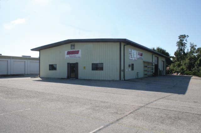

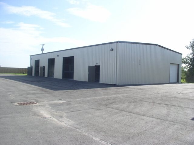

Property Detail
4080 Duncan Rd
402430101003
30 40 24 P6-4 1.74 A M/L COMM AT NW COR SEC 30 TH S ALG W LN 664.06 FT E 116.27 FT TO E ROW SR 35 & POB CONT E 263.73 FT S 309.85 FT W 175.98 FT TO C/L OF FLOW WAY NW ALG C/L 192.69 FT TO E ROW SR 35 N ALG ARC 155.49 FT TO POB 1879/1549 2610/281
Lightindustrial
Charlotte
IG
Florida
AE The base floodplain where base flood elevations are provided. AE Zones are now used on new format FIRMs instead of A1-A30 Zones.
2.73 AC
2024
Charlotte County
2025
Southwest Florida
010100
Punta Gorda, FL
18,144 SF
NEARBY LISTINGS FOR SALE OR LEASE
DEMOGRAPHICS near 4080 Duncan Rd
1 mile
3 mile
5 mile
2025 Total Population
671
6,016
21,372
2030 Population
752
6,659
23,592
Pop Growth 2025-2030
+ 12.07%
+ 10.69%
+ 10.39%
Average Age
53
50
50
2025 Total Households
326
2,725
9,539
HH Growth 2025-2030
+ 11.96%
+ 10.50%
+ 10.32%
Median Household Inc
$34,332
$59,520
$64,962
Avg Household Size
2.00
2.20
2.20
2025 Avg HH Vehicles
2.00
2.00
2.00
Median Home Value
$233,333
$369,752
$339,156
Median Year Built
1988
1990
1995
Nearby Places
Map Layers
Map Styles
 Street
 Aerial
Layers
 Traffic
 Biking
Places
Listings with unknown addresses are not visible on the map
- Restaurants
- Banks
- Shops
- Fitness
- Groceries
PUBLIC TRANSPORTATION
AIRPORT
Punta Gorda
Drive
Walk
Distance
Punta Gorda
12 min
6.6 mi
Southwest Florida International
Drive
Walk
Distance
Southwest Florida International
51 min
41.1 mi
Nearby Properties
Address
Land Use
TOTAL SIZE
Lot Size
Zoning
Address
Land Use
TOTAL SIZE
Lot Size
Zoning
2,148 SF
121.95 AC
PD
Address
Land Use
TOTAL SIZE
Lot Size
Zoning
1,556 SF
23.08 AC
CG
Address
Land Use
TOTAL SIZE
Lot Size
Zoning
31,194 SF
7.93 AC
CG
Address
Land Use
TOTAL SIZE
Lot Size
Zoning
34,854 SF
655 AC
ES
Address
Land Use
TOTAL SIZE
Lot Size
Zoning
8,750 SF
21.19 AC
CG
Address
Land Use
TOTAL SIZE
Lot Size
Zoning
720 SF
314 AC
PD
Address
Land Use
TOTAL SIZE
Lot Size
Zoning
2,400 SF
1.65 AC
IG
Address
Land Use
TOTAL SIZE
Lot Size
Zoning
16,969 SF
81.30 AC
EM
Address
Land Use
TOTAL SIZE
Lot Size
Zoning
18,256 SF
5.20 AC
RE1
Address
Land Use
TOTAL SIZE
Lot Size
Zoning
21,609 SF
20 AC
AG
Address
Land Use
TOTAL SIZE
Lot Size
Zoning
13.53 AC
CG
Address
Land Use
TOTAL SIZE
Lot Size
Zoning
10 AC
ECAP
Address
Land Use
TOTAL SIZE
Lot Size
Zoning
1,960 SF
2.03 AC
IG
Address
Land Use
TOTAL SIZE
Lot Size
Zoning
1,416 SF
3.85 AC
RMF5
Address
Land Use
TOTAL SIZE
Lot Size
Zoning
4,926 SF
8.10 AC
PKR
Address
Land Use
TOTAL SIZE
Lot Size
Zoning
15,000 SF
1.50 AC
IG
Address
Land Use
TOTAL SIZE
Lot Size
Zoning
8,823 SF
73.60 AC
RE1
Address
Land Use
TOTAL SIZE
Lot Size
Zoning
10,500 SF
0.97 AC
CG
Address
Land Use
TOTAL SIZE
Lot Size
Zoning
12,360 SF
1.59 AC
CG
Address
Land Use
TOTAL SIZE
Lot Size
Zoning
5,400 SF
7.09 AC
CG
Address
Land Use
TOTAL SIZE
Lot Size
Zoning
11,776 SF
0.90 AC
IG
Address
Land Use
TOTAL SIZE
Lot Size
Zoning
6,960 SF
0.86 AC
CG
Address
Land Use
TOTAL SIZE
Lot Size
Zoning
8,500 SF
0.76 AC
IG
Address
Land Use
TOTAL SIZE
Lot Size
Zoning
4,881 SF
3.95 AC
CG
Address
Land Use
TOTAL SIZE
Lot Size
Zoning
3,881 SF
1.49 AC
CG
Address
Land Use
TOTAL SIZE
Lot Size
Zoning
2,332 SF
7.13 AC
II
Address
Land Use
TOTAL SIZE
Lot Size
Zoning
9,086 SF
1.46 AC
CG
Address
Land Use
TOTAL SIZE
Lot Size
Zoning
7,500 SF
0.83 AC
IG
Address
Land Use
TOTAL SIZE
Lot Size
Zoning
6,109 SF
2 AC
RE1
The World's #1 Commercial Real Estate Marketplace
Connect with us
© 2026 CoStar Group
The information above has been obtained from sources believed reliable. While we do not doubt its accuracy we have not verified it and make no guarantee, warranty or representation about it. It is your responsibility to independently confirm its accuracy and completeness. Any projections, opinions, assumptions, or estimates used are for example only and do not represent the current or future performance of the property. The value of this transaction to you depends on tax and other factors which should be evaluated by your tax, financial, and legal advisors. You and your advisors should conduct a careful, independent investigation of the property to determine to your satisfaction the suitability of the property for your needs.