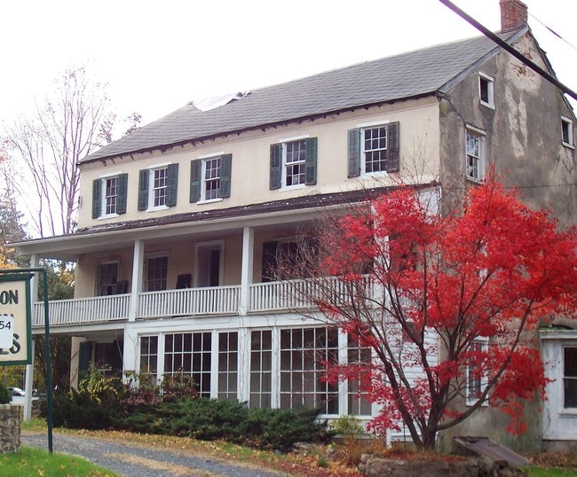
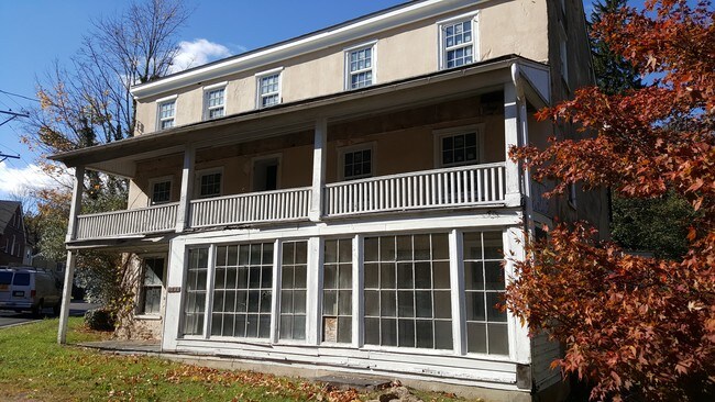
Property Record
4092 Route 202, Doylestown, PA 18902

Property Detail
4092 Route 202
06-010-015
NW COR US202 & T394 100X105
Transientlodging
Bucks
VC1
Pennsylvania
C and X Area of minimal flood hazard, usually depicted on FIRMs as above the 500-year flood level.
0.14 AC
2024
Central Bucks County
2025
Philadelphia
104503
Philadelphia-Camden-Wilmington, PA-NJ-DE-MD
4,450 SF
NEARBY LISTINGS FOR SALE OR LEASE
-
-
View all Doylestown listings for sale on LoopNet.com
DEMOGRAPHICS near 4092 Route 202
1 mile
3 mile
5 mile
2025 Total Population
2,276
32,722
69,230
2030 Population
2,239
33,032
69,618
Pop Growth 2025-2030
(1.63%)
+ 0.95%
+ 0.56%
Average Age
45
45
45
2025 Total Households
820
12,875
25,869
HH Growth 2025-2030
(1.83%)
+ 1.48%
+ 0.82%
Median Household Inc
$198,725
$141,606
$140,039
Avg Household Size
2.80
2.50
2.50
2025 Avg HH Vehicles
3.00
2.00
2.00
Median Home Value
$777,777
$695,338
$676,039
Median Year Built
1974
1983
1987
Nearby Places
Map Layers
Map Styles
 Street
 Aerial
Transit
 Traffic
 Biking
Places
Listings with unknown addresses are not visible on the map
- Restaurants
- Banks
- Shops
- Fitness
- Groceries
PUBLIC TRANSPORTATION
COMMUTER RAIL
Doylestown (R5 - Southeastern Pennsylvania Transportation Authority Regional Rail (SEPTA Regional Rail))
Drive
Walk
Distance
Doylestown (R5 - Southeastern Pennsylvania Transportation Authority Regional Rail (SEPTA Regional Rail))
6 min
2.8 mi
Delaware Valley College (R5 - Southeastern Pennsylvania Transportation Authority Regional Rail (SEPTA Regional Rail))
Drive
Walk
Distance
Delaware Valley College (R5 - Southeastern Pennsylvania Transportation Authority Regional Rail (SEPTA Regional Rail))
10 min
5.5 mi
AIRPORT
Trenton Mercer
Drive
Walk
Distance
Trenton Mercer
33 min
19.6 mi
Lehigh Valley International
Drive
Walk
Distance
Lehigh Valley International
60 min
35.1 mi
Philadelphia International
Drive
Walk
Distance
Philadelphia International
71 min
42.0 mi
Freight Ports
Port of Philadelphia
Drive
Walk
Distance
Port of Philadelphia
49 min
27.7 mi
SALE & LEASE HISTORY
LISTING DATE
SALE/LEASE

Mar 23, 2018
For Sale
Aug 02, 2017
For Sale
Nearby Properties
Address
Land Use
TOTAL SIZE
Lot Size
Zoning
Address
Land Use
TOTAL SIZE
Lot Size
Zoning
254,699 SF
22.06 AC
RC
Address
Land Use
TOTAL SIZE
Lot Size
Zoning
192,365 SF
30.81 AC
C2
Address
Land Use
TOTAL SIZE
Lot Size
Zoning
90,000 SF
7.25 AC
R2
Address
Land Use
TOTAL SIZE
Lot Size
Zoning
77,630 SF
28.53 AC
R2B
Address
Land Use
TOTAL SIZE
Lot Size
Zoning
91,222 SF
13.75 AC
R2
Address
Land Use
TOTAL SIZE
Lot Size
Zoning
109,660 SF
9.81 AC
R3
Address
Land Use
TOTAL SIZE
Lot Size
Zoning
97,496 SF
12.67 AC
R3
Address
Land Use
TOTAL SIZE
Lot Size
Zoning
60,500 SF
5.90 AC
C2
Address
Land Use
TOTAL SIZE
Lot Size
Zoning
230,150 SF
12.10 AC
CR-H
Address
Land Use
TOTAL SIZE
Lot Size
Zoning
77,964 SF
9.79 AC
R3
Address
Land Use
TOTAL SIZE
Lot Size
Zoning
32,319 SF
7.30 AC
C1
Address
Land Use
TOTAL SIZE
Lot Size
Zoning
114,588 SF
0.82 AC
FC
Address
Land Use
TOTAL SIZE
Lot Size
Zoning
50,049 SF
5.45 AC
PC1
Address
Land Use
TOTAL SIZE
Lot Size
Zoning
16,828 SF
3.28 AC
R2
Address
Land Use
TOTAL SIZE
Lot Size
Zoning
38,320 SF
11.91 AC
AG
Address
Land Use
TOTAL SIZE
Lot Size
Zoning
51,286 SF
12.56 AC
R1
Address
Land Use
TOTAL SIZE
Lot Size
Zoning
21,285 SF
118.88 AC
R1
Address
Land Use
TOTAL SIZE
Lot Size
Zoning
25,043 SF
0.36 AC
LC
Address
Land Use
TOTAL SIZE
Lot Size
Zoning
32,298 SF
3.97 AC
R3
Address
Land Use
TOTAL SIZE
Lot Size
Zoning
45,479 SF
6.79 AC
LC
Address
Land Use
TOTAL SIZE
Lot Size
Zoning
25,479 SF
15.35 AC
I
Address
Land Use
TOTAL SIZE
Lot Size
Zoning
36,635 SF
2.97 AC
CR-H
Address
Land Use
TOTAL SIZE
Lot Size
Zoning
85,416 SF
4.30 AC
PC1
Address
Land Use
TOTAL SIZE
Lot Size
Zoning
23,038 SF
149.20 AC
AG
Address
Land Use
TOTAL SIZE
Lot Size
Zoning
34,068 SF
1.09 AC
R2
Address
Land Use
TOTAL SIZE
Lot Size
Zoning
15,336 SF
9.10 AC
R3
Address
Land Use
TOTAL SIZE
Lot Size
Zoning
38,530 SF
2.38 AC
RC1
Address
Land Use
TOTAL SIZE
Lot Size
Zoning
190,326 SF
8.95 AC
C1
Address
Land Use
TOTAL SIZE
Lot Size
Zoning
45,953 SF
2.12 AC
C2
Address
Land Use
TOTAL SIZE
Lot Size
Zoning
27,042 SF
4.02 AC
C1
The World's #1 Commercial Real Estate Marketplace
Connect with us
© 2026 CoStar Group
The information above has been obtained from sources believed reliable. While we do not doubt its accuracy we have not verified it and make no guarantee, warranty or representation about it. It is your responsibility to independently confirm its accuracy and completeness. Any projections, opinions, assumptions, or estimates used are for example only and do not represent the current or future performance of the property. The value of this transaction to you depends on tax and other factors which should be evaluated by your tax, financial, and legal advisors. You and your advisors should conduct a careful, independent investigation of the property to determine to your satisfaction the suitability of the property for your needs.