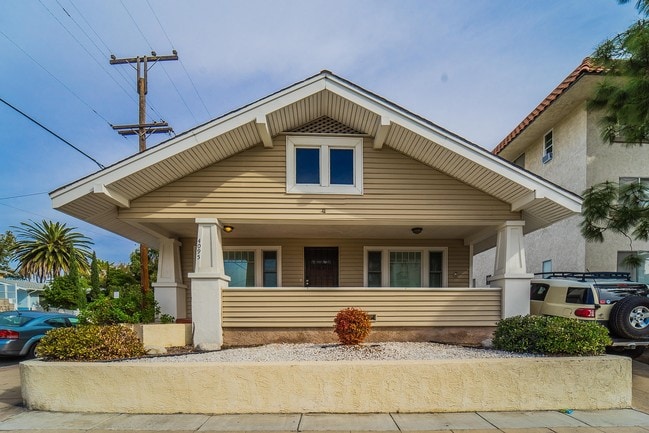
Property Record
4095 Front St, San Diego, CA 92103


Save to a Folder
{{folder.Name}}
{{folder.ListingIds.length}} Properties
{{folder.ListingIds.length}} Property
Create a New Folder
Property Detail
4095 Front St
444-492-01
BLK 1 LOT 1 TR 000892
Multifamilydwelling
San Diego
RM-3-9
California
B and X Area of moderate flood hazard, usually the area between the limits of the 100-year and 500-year floods.
1
2025
0.12 AC
2025
Hillcrest
000400
San Diego
3,534 SF
San Diego-Chula Vista-Carlsbad, CA
NEARBY LISTINGS FOR SALE OR LEASE
DEMOGRAPHICS near 4095 Front St
1 mile
3 mile
5 mile
2025 Total Population
24,839
227,875
526,560
2030 Population
25,207
230,921
531,281
Pop Growth 2025-2030
+ 1.48%
+ 1.34%
+ 0.90%
Average Age
43
40
39
2025 Total Households
14,170
111,904
224,232
HH Growth 2025-2030
+ 1.42%
+ 1.39%
+ 0.96%
Median Household Inc
$104,330
$98,972
$95,160
Avg Household Size
1.70
1.90
2.20
2025 Avg HH Vehicles
1.00
1.00
2.00
Median Home Value
$946,334
$895,128
$899,909
Median Year Built
1974
1980
1974
Nearby Places
Map Layers
Map Styles
 Street
 Aerial
Layers
 Traffic
 Biking
Places
Listings with unknown addresses are not visible on the map
- Restaurants
- Banks
- Shops
- Fitness
- Groceries
PUBLIC TRANSPORTATION
COMMUTER RAIL
Old Town Transit Center (Coaster - San Diego North County Transit District (Coaster/Sprinter/Breeze))
Drive
Walk
Distance
Old Town Transit Center (Coaster - San Diego North County Transit District (Coaster/Sprinter/Breeze))
6 min
3.1 mi
San Diego (Santa Fe Depot) (Coaster - San Diego North County Transit District (Coaster/Sprinter/Breeze))
Drive
Walk
Distance
San Diego (Santa Fe Depot) (Coaster - San Diego North County Transit District (Coaster/Sprinter/Breeze))
7 min
3.1 mi
AIRPORT
San Diego International
Drive
Walk
Distance
San Diego International
5 min
2.4 mi
SALE & LEASE HISTORY
LISTING DATE
SALE/LEASE

May 07, 2024
For Sale
May 07, 2019
For Sale
Mar 17, 2025
For Sale
Feb 05, 2018
For Sale
Nearby Properties
Address
Land Use
TOTAL SIZE
Lot Size
Zoning
Address
Land Use
TOTAL SIZE
Lot Size
Zoning
8.75 AC
60
Address
Land Use
TOTAL SIZE
Lot Size
Zoning
30,000 SF
62.51 AC
MVPD-MV-CR
Address
Land Use
TOTAL SIZE
Lot Size
Zoning
5.99 AC
C
Address
Land Use
TOTAL SIZE
Lot Size
Zoning
3.24 AC
C
Address
Land Use
TOTAL SIZE
Lot Size
Zoning
0.33 AC
CCPD-NC
Address
Land Use
TOTAL SIZE
Lot Size
Zoning
1.38 AC
CCPD-R
Address
Land Use
TOTAL SIZE
Lot Size
Zoning
11.59 AC
CO-3-1
Address
Land Use
TOTAL SIZE
Lot Size
Zoning
12.97 AC
RM-3-7
Address
Land Use
TOTAL SIZE
Lot Size
Zoning
37.33 AC
C
Address
Land Use
TOTAL SIZE
Lot Size
Zoning
9,999 SF
1.18 AC
C
Address
Land Use
TOTAL SIZE
Lot Size
Zoning
107.28 AC
UNZONED
Address
Land Use
TOTAL SIZE
Lot Size
Zoning
496,552 SF
27.12 AC
M
Address
Land Use
TOTAL SIZE
Lot Size
Zoning
0.21 AC
CCPD-R
Address
Land Use
TOTAL SIZE
Lot Size
Zoning
10,000 SF
0.21 AC
CCPD-NC
Address
Land Use
TOTAL SIZE
Lot Size
Zoning
1.38 AC
CCPD-CORE
Address
Land Use
TOTAL SIZE
Lot Size
Zoning
18.97 AC
C
Address
Land Use
TOTAL SIZE
Lot Size
Zoning
2.53 AC
EMX-1
Address
Land Use
TOTAL SIZE
Lot Size
Zoning
CCPD-ER
Address
Land Use
TOTAL SIZE
Lot Size
Zoning
1.51 AC
CC-3-9
Address
Land Use
TOTAL SIZE
Lot Size
Zoning
0.57 AC
CCPD-NC
Address
Land Use
TOTAL SIZE
Lot Size
Zoning
1.38 AC
CCPD-R
Address
Land Use
TOTAL SIZE
Lot Size
Zoning
RM-4-10
Address
Land Use
TOTAL SIZE
Lot Size
Zoning
6.96 AC
MVPD-MVR-4
Address
Land Use
TOTAL SIZE
Lot Size
Zoning
19.25 AC
CC-3-5
Address
Land Use
TOTAL SIZE
Lot Size
Zoning
15.37 AC
CC-3-8
Address
Land Use
TOTAL SIZE
Lot Size
Zoning
0.24 AC
CCPD-CORE
Address
Land Use
TOTAL SIZE
Lot Size
Zoning
CCPD-PC
Address
Land Use
TOTAL SIZE
Lot Size
Zoning
2.50 AC
MVPD-MV-CO
Address
Land Use
TOTAL SIZE
Lot Size
Zoning
5.35 AC
MVPD-MV-CR
Address
Land Use
TOTAL SIZE
Lot Size
Zoning
0.58 AC
CCPD-CORE
The World's #1 Commercial Real Estate Marketplace
Connect with us
© 2026 CoStar Group
The information above has been obtained from sources believed reliable. While we do not doubt its accuracy we have not verified it and make no guarantee, warranty or representation about it. It is your responsibility to independently confirm its accuracy and completeness. Any projections, opinions, assumptions, or estimates used are for example only and do not represent the current or future performance of the property. The value of this transaction to you depends on tax and other factors which should be evaluated by your tax, financial, and legal advisors. You and your advisors should conduct a careful, independent investigation of the property to determine to your satisfaction the suitability of the property for your needs.