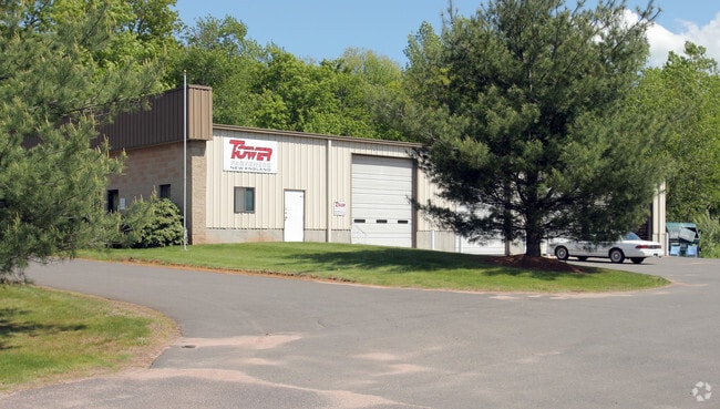
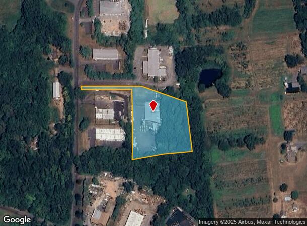
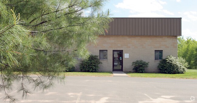
Property Record
41 Industrial Park Access Rd, Middlefield, CT 06455
NEARBY LISTINGS FOR SALE OR LEASE
Property Detail
41 Industrial Park Access Rd
MFLD-000018-000000-000027-000013
Middlesex
Industrialgeneral
Connecticut
X
27-13
09009C0330H
2.61 AC
2025
NW Middlesex/Mid'town
2025
Hartford
580100
Hartford-West Hartford-East Hartford, CT
8,000 SF
DEMOGRAPHICS near 41 Industrial Park Access Rd
1 Mile
3 Mile
5 Mile
2024 Total Population
961
11,434
53,046
2029 Population
947
11,352
52,687
Pop Growth 2024-2029
(1.46%)
(0.72%)
(0.68%)
Average Age
44
44
42
2024 Total Households
391
4,688
21,369
HH Growth 2024-2029
(1.79%)
(0.85%)
(0.59%)
Median Household Inc
$99,876
$102,209
$85,177
Avg Household Size
2.40
2.40
2.30
2024 Avg HH Vehicles
2.00
2.00
2.00
Median Home Value
$305,909
$299,461
$271,120
Median Year Built
1974
1973
1967
Nearby Places
Map Layers
Map Styles
 Street
 Aerial
- Restaurants
- Banks
- Shops
- Fitness
- Groceries
PUBLIC TRANSPORTATION
COMMUTER RAIL
DRIVE
WALK
Distance
19 min
9.4 mi
DRIVE
WALK
Distance
19 min
9.5 mi
AIRPORT
Tweed/New Haven
DRIVE
WALK
Distance
Tweed/New Haven
45 min
25.1 mi
Bradley International
DRIVE
WALK
Distance
Bradley International
60 min
37.3 mi
Freight Ports
Port of New Haven
DRIVE
WALK
Distance
Port of New Haven
39 min
24.0 mi
Nearby Properties
Address
Land Use
TOTAL SIZE
Lot Size
Zoning
Address
Land Use
TOTAL SIZE
Lot Size
Zoning
197,789 SF
31.92 AC
R-15
Address
Land Use
TOTAL SIZE
Lot Size
Zoning
108,540 SF
22.99 AC
R-15
Address
Land Use
TOTAL SIZE
Lot Size
Zoning
10.10 AC
M
Address
Land Use
TOTAL SIZE
Lot Size
Zoning
54,264 SF
15 AC
PRD
Address
Land Use
TOTAL SIZE
Lot Size
Zoning
124,940 SF
49.46 AC
FARM -
Address
Land Use
TOTAL SIZE
Lot Size
Zoning
92,968 SF
20.35 AC
R-15
Address
Land Use
TOTAL SIZE
Lot Size
Zoning
20.60 AC
I-4
Address
Land Use
TOTAL SIZE
Lot Size
Zoning
49,299 SF
19.98 AC
IPD1
Address
Land Use
TOTAL SIZE
Lot Size
Zoning
19,186 SF
103.50 AC
R-15
Address
Land Use
TOTAL SIZE
Lot Size
Zoning
40,938 SF
14.53 AC
FARM -
Address
Land Use
TOTAL SIZE
Lot Size
Zoning
36,106 SF
14.73 AC
MD
Address
Land Use
TOTAL SIZE
Lot Size
Zoning
32.52 AC
AG2
Address
Land Use
TOTAL SIZE
Lot Size
Zoning
62,967 SF
9.40 AC
MAIN S
Address
Land Use
TOTAL SIZE
Lot Size
Zoning
59,557 SF
12.24 AC
I-4
Address
Land Use
TOTAL SIZE
Lot Size
Zoning
30.51 AC
MAIN S
Address
Land Use
TOTAL SIZE
Lot Size
Zoning
32,375 SF
18.94 AC
FARM -
Address
Land Use
TOTAL SIZE
Lot Size
Zoning
4.35 AC
R-15
Address
Land Use
TOTAL SIZE
Lot Size
Zoning
93,345 SF
50.98 AC
FARM -
Address
Land Use
TOTAL SIZE
Lot Size
Zoning
36.01 AC
I-4
Address
Land Use
TOTAL SIZE
Lot Size
Zoning
3.27 AC
HEAVY
Address
Land Use
TOTAL SIZE
Lot Size
Zoning
18,892 SF
0.79 AC
R-15
Address
Land Use
TOTAL SIZE
Lot Size
Zoning
11.21 AC
R-15
Address
Land Use
TOTAL SIZE
Lot Size
Zoning
12.62 AC
HEAVY
Address
Land Use
TOTAL SIZE
Lot Size
Zoning
264 AC
HEAVY
Address
Land Use
TOTAL SIZE
Lot Size
Zoning
183.67 AC
AG2
Address
Land Use
TOTAL SIZE
Lot Size
Zoning
26,750 SF
5.30 AC
MXI
Address
Land Use
TOTAL SIZE
Lot Size
Zoning
15,661 SF
1.07 AC
HD2
Address
Land Use
TOTAL SIZE
Lot Size
Zoning
6.40 AC
I-4
Address
Land Use
TOTAL SIZE
Lot Size
Zoning
18.08 AC
MAIN S
Address
Land Use
TOTAL SIZE
Lot Size
Zoning
1.98 AC
R-30
The World's #1 Commercial Real Estate Marketplace
Connect with us
© 2025 CoStar Group
The information above has been obtained from sources believed reliable. While we do not doubt its accuracy we have not verified it and make no guarantee, warranty or representation about it. It is your responsibility to independently confirm its accuracy and completeness. Any projections, opinions, assumptions, or estimates used are for example only and do not represent the current or future performance of the property. The value of this transaction to you depends on tax and other factors which should be evaluated by your tax, financial, and legal advisors. You and your advisors should conduct a careful, independent investigation of the property to determine to your satisfaction the suitability of the property for your needs.