Property Record
41 State Highway 67, Woodland Park, CO 80863
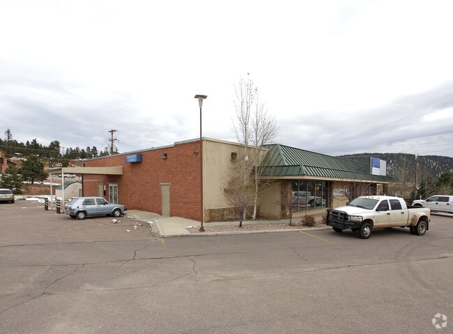

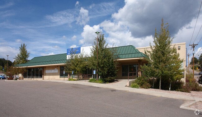
Property Detail
41 State Highway 67
R0000748
L7-9 B25 HIGHLAND ADD
Medicalbuilding
Teller
WP
Colorado
B and X Area of moderate flood hazard, usually the area between the limits of the 100-year and 500-year floods.
7-9
2025
0.53 AC
2024
Teller County
010104
Colorado Springs
9,770 SF
Colorado Springs, CO
NEARBY LISTINGS FOR SALE OR LEASE
DEMOGRAPHICS near 41 State Highway 67
1 mile
3 mile
5 mile
2025 Total Population
4,833
10,878
13,089
2030 Population
4,770
10,766
12,992
Pop Growth 2025-2030
(1.30%)
(1.03%)
(0.74%)
Average Age
45
46
46
2025 Total Households
2,007
4,521
5,474
HH Growth 2025-2030
(1.35%)
(1.04%)
(0.75%)
Median Household Inc
$95,148
$101,109
$99,403
Avg Household Size
2.40
2.40
2.30
2025 Avg HH Vehicles
2.00
2.00
2.00
Median Home Value
$536,111
$573,013
$572,346
Median Year Built
1986
1987
1986
Nearby Places
Map Layers
Map Styles
 Street
 Aerial
Transit
 Traffic
 Biking
Places
Listings with unknown addresses are not visible on the map
- Restaurants
- Banks
- Shops
- Fitness
- Groceries
PUBLIC TRANSPORTATION
AIRPORT
City of Colorado Springs Municipal
Drive
Walk
Distance
City of Colorado Springs Municipal
48 min
29.4 mi
Freight Ports
Tulsa Port Of Catoosa
Drive
Walk
Distance
Tulsa Port Of Catoosa
772 min
713.5 mi
Nearby Properties
Address
Land Use
TOTAL SIZE
Lot Size
Zoning
Address
Land Use
TOTAL SIZE
Lot Size
Zoning
41,542 SF
145.43 AC
Address
Land Use
TOTAL SIZE
Lot Size
Zoning
161,632 SF
19.24 AC
A1
Address
Land Use
TOTAL SIZE
Lot Size
Zoning
54,600 SF
6.70 AC
WP
Address
Land Use
TOTAL SIZE
Lot Size
Zoning
15,414 SF
1.76 AC
WP
Address
Land Use
TOTAL SIZE
Lot Size
Zoning
26,664 SF
9.24 AC
MHP
Address
Land Use
TOTAL SIZE
Lot Size
Zoning
20,398 SF
Address
Land Use
TOTAL SIZE
Lot Size
Zoning
29,161 SF
2.04 AC
Address
Land Use
TOTAL SIZE
Lot Size
Zoning
32,146 SF
2.06 AC
Address
Land Use
TOTAL SIZE
Lot Size
Zoning
8,645 SF
3.09 AC
WP
Address
Land Use
TOTAL SIZE
Lot Size
Zoning
13,221 SF
1.53 AC
Address
Land Use
TOTAL SIZE
Lot Size
Zoning
26,268 SF
1.73 AC
Address
Land Use
TOTAL SIZE
Lot Size
Zoning
16,458 SF
16.04 AC
A1
Address
Land Use
TOTAL SIZE
Lot Size
Zoning
35,209 SF
6.04 AC
WP
Address
Land Use
TOTAL SIZE
Lot Size
Zoning
23,892 SF
5.41 AC
R1SR
Address
Land Use
TOTAL SIZE
Lot Size
Zoning
21,970 SF
5.24 AC
Address
Land Use
TOTAL SIZE
Lot Size
Zoning
33,680 SF
1.30 AC
WP
Address
Land Use
TOTAL SIZE
Lot Size
Zoning
16,200 SF
2.10 AC
WP
Address
Land Use
TOTAL SIZE
Lot Size
Zoning
8,520 SF
1.36 AC
WPCC
Address
Land Use
TOTAL SIZE
Lot Size
Zoning
5,041 SF
2.49 AC
WP
Address
Land Use
TOTAL SIZE
Lot Size
Zoning
32,400 SF
7 AC
A1HSCLI
Address
Land Use
TOTAL SIZE
Lot Size
Zoning
18,112 SF
6.33 AC
WP
Address
Land Use
TOTAL SIZE
Lot Size
Zoning
10,581 SF
1.14 AC
WP
Address
Land Use
TOTAL SIZE
Lot Size
Zoning
23,056 SF
2.46 AC
Address
Land Use
TOTAL SIZE
Lot Size
Zoning
12,839 SF
5.94 AC
WP
Address
Land Use
TOTAL SIZE
Lot Size
Zoning
1,192 SF
1.60 AC
C1
Address
Land Use
TOTAL SIZE
Lot Size
Zoning
9,982 SF
1.12 AC
WP
Address
Land Use
TOTAL SIZE
Lot Size
Zoning
1,480 SF
40 AC
A-5
Address
Land Use
TOTAL SIZE
Lot Size
Zoning
8,798 SF
4.88 AC
WPPUD
Address
Land Use
TOTAL SIZE
Lot Size
Zoning
76.58 AC
Address
Land Use
TOTAL SIZE
Lot Size
Zoning
14,171 SF
1.37 AC
WP
The World's #1 Commercial Real Estate Marketplace
Connect with us
© 2026 CoStar Group
The information above has been obtained from sources believed reliable. While we do not doubt its accuracy we have not verified it and make no guarantee, warranty or representation about it. It is your responsibility to independently confirm its accuracy and completeness. Any projections, opinions, assumptions, or estimates used are for example only and do not represent the current or future performance of the property. The value of this transaction to you depends on tax and other factors which should be evaluated by your tax, financial, and legal advisors. You and your advisors should conduct a careful, independent investigation of the property to determine to your satisfaction the suitability of the property for your needs.