Property Record
41 Veterans Memorial Hwy Se, Mableton, GA 30126
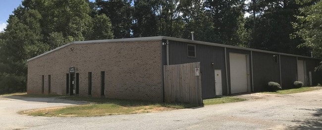
This Property Is For Sale
NEARBY LISTINGS FOR SALE OR LEASE
Property Detail
41 Veterans Memorial Hwy Se
18-0043-0-012-0
DEVELOPMENT LAND
Industrialgeneral
Cobb
X
Georgia
13121C0216F
1.01 AC
2025
I-20 W/Douglasville
2025
Atlanta
031317
Atlanta-Sandy Springs-Roswell, GA
10,000 SF
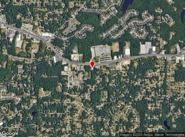
DEMOGRAPHICS near 41 Veterans Memorial Hwy Se
1 Mile
3 Mile
5 Mile
2024 Total Population
6,533
59,086
163,659
2029 Population
6,682
60,280
167,161
Pop Growth 2024-2029
+ 2.28%
+ 2.02%
+ 2.14%
Average Age
38
37
38
2024 Total Households
2,477
21,930
64,704
HH Growth 2024-2029
+ 2.22%
+ 2.02%
+ 2.15%
Median Household Inc
$69,550
$80,961
$75,614
Avg Household Size
2.60
2.60
2.50
2024 Avg HH Vehicles
2.00
2.00
2.00
Median Home Value
$308,997
$304,496
$308,535
Median Year Built
1973
1988
1988
Nearby Places
- Restaurants
- Banks
- Shops
- Fitness
- Groceries
PUBLIC TRANSPORTATION
AIRPORT
Hartsfield - Jackson Atlanta International
DRIVE
WALK
Distance
Hartsfield - Jackson Atlanta International
32 min
20.8 mi
Freight Ports
Georgia Ports - Savannah
DRIVE
WALK
Distance
Georgia Ports - Savannah
295 min
260.1 mi
Nearby Properties
Address
Land Use
TOTAL SIZE
Lot Size
Zoning
Address
Land Use
TOTAL SIZE
Lot Size
Zoning
290,784 SF
21.09 AC
RM-12
Address
Land Use
TOTAL SIZE
Lot Size
Zoning
694,436 SF
36.80 AC
HI
Address
Land Use
TOTAL SIZE
Lot Size
Zoning
283,396 SF
29.88 AC
RM-12
Address
Land Use
TOTAL SIZE
Lot Size
Zoning
241,200 SF
18.40 AC
RM-12
Address
Land Use
TOTAL SIZE
Lot Size
Zoning
191,400 SF
25.70 AC
LI
Address
Land Use
TOTAL SIZE
Lot Size
Zoning
152,348 SF
12.76 AC
RM-12
Address
Land Use
TOTAL SIZE
Lot Size
Zoning
150,440 SF
25 AC
LI
Address
Land Use
TOTAL SIZE
Lot Size
Zoning
350,840 SF
22.90 AC
LI
Address
Land Use
TOTAL SIZE
Lot Size
Zoning
151,436 SF
11.42 AC
RM-12
Address
Land Use
TOTAL SIZE
Lot Size
Zoning
353,269 SF
32.80 AC
LI
Address
Land Use
TOTAL SIZE
Lot Size
Zoning
377,059 SF
32.20 AC
LI
Address
Land Use
TOTAL SIZE
Lot Size
Zoning
217,412 SF
18.29 AC
RM-12
Address
Land Use
TOTAL SIZE
Lot Size
Zoning
16.56 AC
LI
Address
Land Use
TOTAL SIZE
Lot Size
Zoning
3.46 AC
RM-12
Address
Land Use
TOTAL SIZE
Lot Size
Zoning
192,776 SF
16.35 AC
RM-12
Address
Land Use
TOTAL SIZE
Lot Size
Zoning
259,325 SF
23.30 AC
LI
Address
Land Use
TOTAL SIZE
Lot Size
Zoning
111,047 SF
14.40 AC
GC
Address
Land Use
TOTAL SIZE
Lot Size
Zoning
111,246 SF
11.28 AC
RM-12
Address
Land Use
TOTAL SIZE
Lot Size
Zoning
121,625 SF
10.40 AC
RM-12
Address
Land Use
TOTAL SIZE
Lot Size
Zoning
109,072 SF
15.23 AC
NRC
Address
Land Use
TOTAL SIZE
Lot Size
Zoning
134,574 SF
11.24 AC
LI
Address
Land Use
TOTAL SIZE
Lot Size
Zoning
114,622 SF
11.31 AC
RM-12
Address
Land Use
TOTAL SIZE
Lot Size
Zoning
119,424 SF
11.32 AC
RM-12
Address
Land Use
TOTAL SIZE
Lot Size
Zoning
150,311 SF
10.88 AC
LI
Address
Land Use
TOTAL SIZE
Lot Size
Zoning
113,244 SF
7.95 AC
RM-12
Address
Land Use
TOTAL SIZE
Lot Size
Zoning
115,380 SF
10.12 AC
RM-12
Address
Land Use
TOTAL SIZE
Lot Size
Zoning
550,800 SF
34.65 AC
HI
Address
Land Use
TOTAL SIZE
Lot Size
Zoning
354,306 SF
15.01 AC
M2
Address
Land Use
TOTAL SIZE
Lot Size
Zoning
89,686 SF
10.60 AC
NRC
Address
Land Use
TOTAL SIZE
Lot Size
Zoning
117,715 SF
7.88 AC
RM-12
The World's #1 Commercial Real Estate Marketplace
Connect with us
© 2025 CoStar Group
The information above has been obtained from sources believed reliable. While we do not doubt its accuracy we have not verified it and make no guarantee, warranty or representation about it. It is your responsibility to independently confirm its accuracy and completeness. Any projections, opinions, assumptions, or estimates used are for example only and do not represent the current or future performance of the property. The value of this transaction to you depends on tax and other factors which should be evaluated by your tax, financial, and legal advisors. You and your advisors should conduct a careful, independent investigation of the property to determine to your satisfaction the suitability of the property for your needs.