Property Record
4101 3Rd St, San Francisco, CA 94124
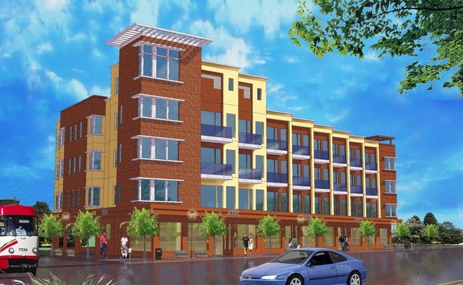


Property Detail
4101 3Rd St
San Francisco-San Mateo-Redwood City, CA
SAN FRANCISCO
5260-001
California
Vacantlandnec
1
M1
0.17 AC
2024
Bayview/Hunters Point
2025
San Francisco
061200
NEARBY LISTINGS FOR SALE OR LEASE
DEMOGRAPHICS near 4101 3Rd St
1 mile
3 mile
5 mile
2025 Total Population
26,896
283,462
713,752
2030 Population
26,739
287,014
722,344
Pop Growth 2025-2030
(0.58%)
+ 1.25%
+ 1.20%
Average Age
41
42
43
2025 Total Households
7,813
109,248
301,585
HH Growth 2025-2030
(0.70%)
+ 1.47%
+ 1.40%
Median Household Inc
$74,747
$136,205
$128,816
Avg Household Size
3.00
2.40
2.20
2025 Avg HH Vehicles
1.00
1.00
1.00
Median Home Value
$1,034,463
$1,085,003
$1,087,459
Median Year Built
1960
1958
1950
Nearby Places
Map Layers
Map Styles
 Street
 Aerial
Layers
 Traffic
 Biking
Places
Listings with unknown addresses are not visible on the map
- Restaurants
- Banks
- Shops
- Fitness
- Groceries
PUBLIC TRANSPORTATION
TRANSIT/SUBWAY
Hudson/Innes Station (T Third Street - San Francisco Municipal Railway (MUNI Metro))
Drive
Walk
Distance
Hudson/Innes Station (T Third Street - San Francisco Municipal Railway (MUNI Metro))
0 min
0 min
0.0 mi
Kirkwood/La Salle Station (T Third Street - San Francisco Municipal Railway (MUNI Metro))
Drive
Walk
Distance
Kirkwood/La Salle Station (T Third Street - San Francisco Municipal Railway (MUNI Metro))
1 min
3 min
0.2 mi
Evans Avenue Station Outbound (T Third Street - San Francisco Municipal Railway (MUNI Metro))
Drive
Walk
Distance
Evans Avenue Station Outbound (T Third Street - San Francisco Municipal Railway (MUNI Metro))
1 min
3 min
0.2 mi
Oakdale/Palou Station (T Third Street - San Francisco Municipal Railway (MUNI Metro))
Drive
Walk
Distance
Oakdale/Palou Station (T Third Street - San Francisco Municipal Railway (MUNI Metro))
2 min
8 min
0.4 mi
Marin Street Station (T Third Street - San Francisco Municipal Railway (MUNI Metro))
Drive
Walk
Distance
Marin Street Station (T Third Street - San Francisco Municipal Railway (MUNI Metro))
3 min
12 min
0.6 mi
COMMUTER RAIL
Drive
Walk
Distance
8 min
3.0 mi
Drive
Walk
Distance
7 min
3.3 mi
AIRPORT
San Francisco International
Drive
Walk
Distance
San Francisco International
19 min
10.9 mi
Metro Oakland International
Drive
Walk
Distance
Metro Oakland International
35 min
22.4 mi
Norman Y Mineta San Jose International
Drive
Walk
Distance
Norman Y Mineta San Jose International
54 min
42.5 mi
Freight Ports
Port of San Francisco
Drive
Walk
Distance
Port of San Francisco
12 min
5.4 mi
SALE & LEASE HISTORY
LISTING DATE
SALE/LEASE

Dec 19, 2024
For Sale
Nearby Properties
Address
Land Use
TOTAL SIZE
Lot Size
Zoning
Address
Land Use
TOTAL SIZE
Lot Size
Zoning
750,370 SF
3.25 AC
MBR3
Address
Land Use
TOTAL SIZE
Lot Size
Zoning
248,303 SF
4.35 AC
Address
Land Use
TOTAL SIZE
Lot Size
Zoning
717,234 SF
3.47 AC
UMU
Address
Land Use
TOTAL SIZE
Lot Size
Zoning
10.92 AC
Address
Land Use
TOTAL SIZE
Lot Size
Zoning
885,581 SF
5.20 AC
M2
Address
Land Use
TOTAL SIZE
Lot Size
Zoning
1.52 AC
C3G
Address
Land Use
TOTAL SIZE
Lot Size
Zoning
2.74 AC
Address
Land Use
TOTAL SIZE
Lot Size
Zoning
313,306 SF
1.23 AC
WMUG
Address
Land Use
TOTAL SIZE
Lot Size
Zoning
314,826 SF
1.85 AC
MB-RA
Address
Land Use
TOTAL SIZE
Lot Size
Zoning
10.92 AC
Address
Land Use
TOTAL SIZE
Lot Size
Zoning
393,918 SF
3.36 AC
WMUG
Address
Land Use
TOTAL SIZE
Lot Size
Zoning
24.37 AC
Address
Land Use
TOTAL SIZE
Lot Size
Zoning
241,659 SF
3.76 AC
Address
Land Use
TOTAL SIZE
Lot Size
Zoning
230,853 SF
3.76 AC
Address
Land Use
TOTAL SIZE
Lot Size
Zoning
302,084 SF
0.88 AC
MBO
Address
Land Use
TOTAL SIZE
Lot Size
Zoning
674,317 SF
3.36 AC
UMU
Address
Land Use
TOTAL SIZE
Lot Size
Zoning
319,119 SF
0.76 AC
Address
Land Use
TOTAL SIZE
Lot Size
Zoning
222,000 SF
1 AC
MB-RA
Address
Land Use
TOTAL SIZE
Lot Size
Zoning
10.92 AC
Address
Land Use
TOTAL SIZE
Lot Size
Zoning
2.93 AC
Address
Land Use
TOTAL SIZE
Lot Size
Zoning
342,727 SF
1.36 AC
C3G
Address
Land Use
TOTAL SIZE
Lot Size
Zoning
291,522 SF
6.66 AC
CM
Address
Land Use
TOTAL SIZE
Lot Size
Zoning
250,884 SF
1.66 AC
MB-RA
Address
Land Use
TOTAL SIZE
Lot Size
Zoning
375,030 SF
0.96 AC
Address
Land Use
TOTAL SIZE
Lot Size
Zoning
248,974 SF
0.88 AC
MBO
Address
Land Use
TOTAL SIZE
Lot Size
Zoning
345,000 SF
1.74 AC
WMUG
Address
Land Use
TOTAL SIZE
Lot Size
Zoning
0.75 AC
SLI
Address
Land Use
TOTAL SIZE
Lot Size
Zoning
428,194 SF
1.65 AC
M1
Address
Land Use
TOTAL SIZE
Lot Size
Zoning
2.22 AC
M1
Address
Land Use
TOTAL SIZE
Lot Size
Zoning
2.06 AC
The World's #1 Commercial Real Estate Marketplace
Connect with us
© 2026 CoStar Group
The information above has been obtained from sources believed reliable. While we do not doubt its accuracy we have not verified it and make no guarantee, warranty or representation about it. It is your responsibility to independently confirm its accuracy and completeness. Any projections, opinions, assumptions, or estimates used are for example only and do not represent the current or future performance of the property. The value of this transaction to you depends on tax and other factors which should be evaluated by your tax, financial, and legal advisors. You and your advisors should conduct a careful, independent investigation of the property to determine to your satisfaction the suitability of the property for your needs.