Property Record
4114 Riggins Mill Rd, Macon, GA 31217

Save to a Folder
{{folder.Name}}
{{folder.ListingIds.length}} Properties
{{folder.ListingIds.length}} Property
Create a New Folder
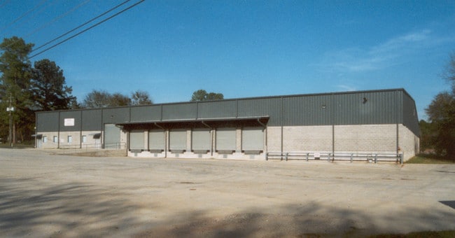
Property Detail
4114 Riggins Mill Rd
V081-0021
Bibb
Warehouse
Georgia
C-2
89
B and X Area of moderate flood hazard, usually the area between the limits of the 100-year and 500-year floods.
2.96 AC
2025
Outlying Bibb County
2025
Atlanta
013302
Macon-Bibb County, GA
50,000 SF
NEARBY LISTINGS FOR SALE OR LEASE
DEMOGRAPHICS near 4114 Riggins Mill Rd
1 mile
3 mile
5 mile
2025 Total Population
1,165
11,602
36,376
2030 Population
1,183
11,744
37,117
Pop Growth 2025-2030
+ 1.55%
+ 1.22%
+ 2.04%
Average Age
41
40
39
2025 Total Households
466
4,444
14,881
HH Growth 2025-2030
+ 1.93%
+ 1.26%
+ 2.09%
Median Household Inc
$61,667
$43,287
$39,007
Avg Household Size
2.30
2.40
2.30
2025 Avg HH Vehicles
2.00
2.00
2.00
Median Home Value
$147,033
$135,580
$148,151
Median Year Built
1971
1969
1968
Nearby Places
Map Layers
Map Styles
 Street
 Aerial
Layers
 Traffic
 Biking
Places
Listings with unknown addresses are not visible on the map
- Restaurants
- Banks
- Shops
- Fitness
- Groceries
SALE & LEASE HISTORY
LISTING DATE
SALE/LEASE

Feb 15, 2022
For Sale
Apr 17, 2023
For Lease
Nearby Properties
Address
Land Use
TOTAL SIZE
Lot Size
Zoning
Address
Land Use
TOTAL SIZE
Lot Size
Zoning
Address
Land Use
TOTAL SIZE
Lot Size
Zoning
Address
Land Use
TOTAL SIZE
Lot Size
Zoning
Address
Land Use
TOTAL SIZE
Lot Size
Zoning
269,568 SF
29.43 AC
M-2
Address
Land Use
TOTAL SIZE
Lot Size
Zoning
Address
Land Use
TOTAL SIZE
Lot Size
Zoning
395,555 SF
246 AC
M-2
Address
Land Use
TOTAL SIZE
Lot Size
Zoning
113,664 SF
10.21 AC
M-2
Address
Land Use
TOTAL SIZE
Lot Size
Zoning
Address
Land Use
TOTAL SIZE
Lot Size
Zoning
Address
Land Use
TOTAL SIZE
Lot Size
Zoning
90,323 SF
16.06 AC
M-2
Address
Land Use
TOTAL SIZE
Lot Size
Zoning
183,682 SF
78.30 AC
M-2
Address
Land Use
TOTAL SIZE
Lot Size
Zoning
283,200 SF
22.92 AC
M-2
Address
Land Use
TOTAL SIZE
Lot Size
Zoning
Address
Land Use
TOTAL SIZE
Lot Size
Zoning
350,100 SF
51.92 AC
M-2
Address
Land Use
TOTAL SIZE
Lot Size
Zoning
Address
Land Use
TOTAL SIZE
Lot Size
Zoning
Address
Land Use
TOTAL SIZE
Lot Size
Zoning
Address
Land Use
TOTAL SIZE
Lot Size
Zoning
Address
Land Use
TOTAL SIZE
Lot Size
Zoning
99,187 SF
13.36 AC
M-2
Address
Land Use
TOTAL SIZE
Lot Size
Zoning
33,396 SF
204.69 AC
M-2
Address
Land Use
TOTAL SIZE
Lot Size
Zoning
Address
Land Use
TOTAL SIZE
Lot Size
Zoning
200,000 SF
20.50 AC
M-2
Address
Land Use
TOTAL SIZE
Lot Size
Zoning
160 SF
243.85 AC
PDE
Address
Land Use
TOTAL SIZE
Lot Size
Zoning
Address
Land Use
TOTAL SIZE
Lot Size
Zoning
178,844 SF
29.31 AC
M-2
Address
Land Use
TOTAL SIZE
Lot Size
Zoning
198,000 SF
16.88 AC
M-2
Address
Land Use
TOTAL SIZE
Lot Size
Zoning
169,200 SF
15.54 AC
M-2
Address
Land Use
TOTAL SIZE
Lot Size
Zoning
624 SF
117.96 AC
R-1A
Address
Land Use
TOTAL SIZE
Lot Size
Zoning
Address
Land Use
TOTAL SIZE
Lot Size
Zoning
51,072 SF
21.18 AC
R-3
The World's #1 Commercial Real Estate Marketplace
Connect with us
© 2026 CoStar Group
The information above has been obtained from sources believed reliable. While we do not doubt its accuracy we have not verified it and make no guarantee, warranty or representation about it. It is your responsibility to independently confirm its accuracy and completeness. Any projections, opinions, assumptions, or estimates used are for example only and do not represent the current or future performance of the property. The value of this transaction to you depends on tax and other factors which should be evaluated by your tax, financial, and legal advisors. You and your advisors should conduct a careful, independent investigation of the property to determine to your satisfaction the suitability of the property for your needs.