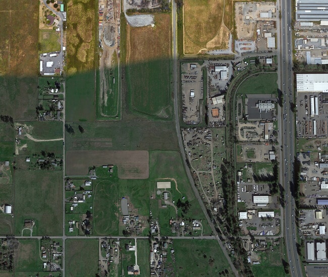
Property Record
4120 Langner Ave, Santa Rosa, CA 95407
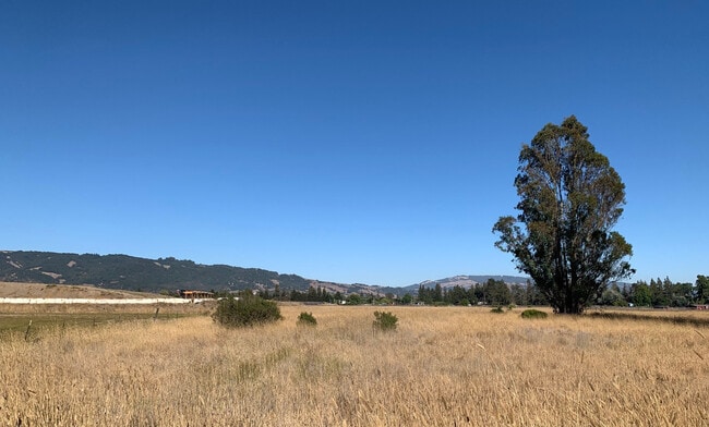

This Property Is For Sale
Property Detail
4120 Langner Ave
Santa Rosa-Petaluma, CA
MAP 27 PG 25 LOT 4
045-013-001
SONOMA
Residentialacreage
California
M35
4
B and X Area of moderate flood hazard, usually the area between the limits of the 100-year and 500-year floods.
10.04 AC
2025
Santa Rosa
2025
North Bay/Santa Rosa
153202
NEARBY LISTINGS FOR SALE OR LEASE
DEMOGRAPHICS near 4120 Langner Ave
1 mile
3 mile
5 mile
2025 Total Population
1,342
58,527
166,218
2030 Population
1,300
58,766
166,554
Pop Growth 2025-2030
(3.13%)
+ 0.41%
+ 0.20%
Average Age
41
39
40
2025 Total Households
418
20,111
59,049
HH Growth 2025-2030
(3.59%)
+ 0.33%
+ 0.20%
Median Household Inc
$79,844
$90,000
$92,205
Avg Household Size
2.80
2.80
2.70
2025 Avg HH Vehicles
3.00
2.00
2.00
Median Home Value
$705,414
$674,029
$705,345
Median Year Built
1963
1985
1980
Nearby Places
Map Layers
Map Styles
 Street
 Aerial
Layers
 Traffic
 Biking
Places
Listings with unknown addresses are not visible on the map
- Restaurants
- Banks
- Shops
- Fitness
- Groceries
PUBLIC TRANSPORTATION
COMMUTER RAIL
Smart Rohnert Park (Main Line - Sonoma Marin Area Rail Transit)
Drive
Walk
Distance
Smart Rohnert Park (Main Line - Sonoma Marin Area Rail Transit)
9 min
3.7 mi
Smart Cotati (Main Line - Sonoma Marin Area Rail Transit)
Drive
Walk
Distance
Smart Cotati (Main Line - Sonoma Marin Area Rail Transit)
12 min
5.5 mi
AIRPORT
Charles M Schulz - Sonoma County
Drive
Walk
Distance
Charles M Schulz - Sonoma County
22 min
13.2 mi
Freight Ports
Port of Richmond
Drive
Walk
Distance
Port of Richmond
61 min
44.8 mi
Nearby Properties
Address
Land Use
TOTAL SIZE
Lot Size
Zoning
Address
Land Use
TOTAL SIZE
Lot Size
Zoning
22,841 SF
8.23 AC
Address
Land Use
TOTAL SIZE
Lot Size
Zoning
23,112 SF
12.30 AC
Address
Land Use
TOTAL SIZE
Lot Size
Zoning
59,220 SF
22.98 AC
C-2
Address
Land Use
TOTAL SIZE
Lot Size
Zoning
4,652 SF
11.09 AC
MLPD
Address
Land Use
TOTAL SIZE
Lot Size
Zoning
28,750 SF
9.35 AC
Address
Land Use
TOTAL SIZE
Lot Size
Zoning
61,756 SF
15.83 AC
CITYRP
Address
Land Use
TOTAL SIZE
Lot Size
Zoning
26,699 SF
6 AC
MLPD
Address
Land Use
TOTAL SIZE
Lot Size
Zoning
29,235 SF
8.08 AC
Address
Land Use
TOTAL SIZE
Lot Size
Zoning
22,869 SF
4.65 AC
Address
Land Use
TOTAL SIZE
Lot Size
Zoning
181,816 SF
8.64 AC
Address
Land Use
TOTAL SIZE
Lot Size
Zoning
10,134 SF
3.03 AC
RM
Address
Land Use
TOTAL SIZE
Lot Size
Zoning
12,640 SF
4.94 AC
CITYRP
Address
Land Use
TOTAL SIZE
Lot Size
Zoning
96,051 SF
5.55 AC
CITYRP
Address
Land Use
TOTAL SIZE
Lot Size
Zoning
85,034 SF
5.43 AC
Address
Land Use
TOTAL SIZE
Lot Size
Zoning
19,444 SF
7.91 AC
C2
Address
Land Use
TOTAL SIZE
Lot Size
Zoning
5,370 SF
4.85 AC
M3
Address
Land Use
TOTAL SIZE
Lot Size
Zoning
213,331 SF
12.53 AC
CREC
Address
Land Use
TOTAL SIZE
Lot Size
Zoning
12,491 SF
5.40 AC
MLPD
Address
Land Use
TOTAL SIZE
Lot Size
Zoning
149,007 SF
0.25 AC
M1RP
Address
Land Use
TOTAL SIZE
Lot Size
Zoning
145,976 SF
7.09 AC
R210
Address
Land Use
TOTAL SIZE
Lot Size
Zoning
7,745 SF
2.28 AC
Address
Land Use
TOTAL SIZE
Lot Size
Zoning
55,826 SF
13.15 AC
CRPD
Address
Land Use
TOTAL SIZE
Lot Size
Zoning
61,880 SF
2.53 AC
Address
Land Use
TOTAL SIZE
Lot Size
Zoning
107,599 SF
2.98 AC
Address
Land Use
TOTAL SIZE
Lot Size
Zoning
67,584 SF
4.79 AC
CITYRP
Address
Land Use
TOTAL SIZE
Lot Size
Zoning
53,600 SF
7.37 AC
C4
Address
Land Use
TOTAL SIZE
Lot Size
Zoning
142,272 SF
0.25 AC
C2
Address
Land Use
TOTAL SIZE
Lot Size
Zoning
144,198 SF
12.08 AC
CRPD
Address
Land Use
TOTAL SIZE
Lot Size
Zoning
26,390 SF
3.33 AC
MLPD
Address
Land Use
TOTAL SIZE
Lot Size
Zoning
38,830 SF
2.09 AC
CITYRP
The World's #1 Commercial Real Estate Marketplace
Connect with us
© 2026 CoStar Group
The information above has been obtained from sources believed reliable. While we do not doubt its accuracy we have not verified it and make no guarantee, warranty or representation about it. It is your responsibility to independently confirm its accuracy and completeness. Any projections, opinions, assumptions, or estimates used are for example only and do not represent the current or future performance of the property. The value of this transaction to you depends on tax and other factors which should be evaluated by your tax, financial, and legal advisors. You and your advisors should conduct a careful, independent investigation of the property to determine to your satisfaction the suitability of the property for your needs.