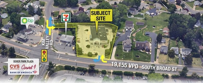
Property Record
4125 S Broad St, Trenton, NJ 08620


Save to a Folder
{{folder.Name}}
{{folder.ListingIds.length}} Properties
{{folder.ListingIds.length}} Property
Create a New Folder
Current Lease Availabilities
Property Detail
4125 S Broad St
03-02632-0000-00002
07957-Z43
Vacantlandnec
Mercer
CC
New Jersey
B and X Area of moderate flood hazard, usually the area between the limits of the 100-year and 500-year floods.
2
2025
1.97 AC
2026
Trenton
003003
Northern New Jersey
9,600 SF
Trenton-Princeton, NJ
NEARBY LISTINGS FOR SALE OR LEASE
DEMOGRAPHICS near 4125 S Broad St
1 mile
3 mile
5 mile
2025 Total Population
9,098
59,551
186,884
2030 Population
9,392
61,352
191,657
Pop Growth 2025-2030
+ 3.23%
+ 3.02%
+ 2.55%
Average Age
46
43
40
2025 Total Households
3,860
23,373
66,698
HH Growth 2025-2030
+ 3.21%
+ 3.20%
+ 2.78%
Median Household Inc
$91,341
$94,482
$88,154
Avg Household Size
2.40
2.40
2.70
2025 Avg HH Vehicles
2.00
2.00
2.00
Median Home Value
$349,683
$337,743
$344,296
Median Year Built
1962
1965
1959
Nearby Places
Map Layers
Map Styles
 Street
 Aerial
Layers
 Traffic
 Biking
Places
Listings with unknown addresses are not visible on the map
- Restaurants
- Banks
- Shops
- Fitness
- Groceries
PUBLIC TRANSPORTATION
COMMUTER RAIL
Trenton Transit Center (NJT) (Northeast Corridor Line - NJ Transit Commuter Rail (NJ Transit), River LINE - River LINE (River LINE))
Drive
Walk
Distance
Trenton Transit Center (NJT) (Northeast Corridor Line - NJ Transit Commuter Rail (NJ Transit), River LINE - River LINE (River LINE))
12 min
5.5 mi
Drive
Walk
Distance
10 min
6.1 mi
AIRPORT
Trenton Mercer
Drive
Walk
Distance
Trenton Mercer
22 min
12.0 mi
Freight Ports
South Jersey Port
Drive
Walk
Distance
South Jersey Port
46 min
33.6 mi
Nearby Properties
Address
Land Use
TOTAL SIZE
Lot Size
Zoning
Address
Land Use
TOTAL SIZE
Lot Size
Zoning
561.91 AC
AG
Address
Land Use
TOTAL SIZE
Lot Size
Zoning
31.05 AC
Address
Land Use
TOTAL SIZE
Lot Size
Zoning
23.13 AC
RD
Address
Land Use
TOTAL SIZE
Lot Size
Zoning
30.94 AC
Address
Land Use
TOTAL SIZE
Lot Size
Zoning
51.10 AC
Address
Land Use
TOTAL SIZE
Lot Size
Zoning
60.26 AC
RD
Address
Land Use
TOTAL SIZE
Lot Size
Zoning
585,222 SF
44.82 AC
RD
Address
Land Use
TOTAL SIZE
Lot Size
Zoning
392,050 SF
45.57 AC
Address
Land Use
TOTAL SIZE
Lot Size
Zoning
Address
Land Use
TOTAL SIZE
Lot Size
Zoning
18.33 AC
Address
Land Use
TOTAL SIZE
Lot Size
Zoning
266,000 SF
56.90 AC
RD
Address
Land Use
TOTAL SIZE
Lot Size
Zoning
64.45 AC
REO5
Address
Land Use
TOTAL SIZE
Lot Size
Zoning
339,339 SF
33.91 AC
RD
Address
Land Use
TOTAL SIZE
Lot Size
Zoning
9.63 AC
RD
Address
Land Use
TOTAL SIZE
Lot Size
Zoning
263,232 SF
39.16 AC
CI
Address
Land Use
TOTAL SIZE
Lot Size
Zoning
23.53 AC
AT
Address
Land Use
TOTAL SIZE
Lot Size
Zoning
6.79 AC
R7
Address
Land Use
TOTAL SIZE
Lot Size
Zoning
15.80 AC
C
Address
Land Use
TOTAL SIZE
Lot Size
Zoning
21.62 AC
RD
Address
Land Use
TOTAL SIZE
Lot Size
Zoning
Address
Land Use
TOTAL SIZE
Lot Size
Zoning
23,540 SF
18.14 AC
HC
Address
Land Use
TOTAL SIZE
Lot Size
Zoning
5,079 SF
7.82 AC
Address
Land Use
TOTAL SIZE
Lot Size
Zoning
Address
Land Use
TOTAL SIZE
Lot Size
Zoning
77,722 SF
39.13 AC
Address
Land Use
TOTAL SIZE
Lot Size
Zoning
60,564 SF
18.37 AC
RD
Address
Land Use
TOTAL SIZE
Lot Size
Zoning
141,175 SF
17.06 AC
RD
Address
Land Use
TOTAL SIZE
Lot Size
Zoning
93,840 SF
2.89 AC
RD
Address
Land Use
TOTAL SIZE
Lot Size
Zoning
21.91 AC
R10
Address
Land Use
TOTAL SIZE
Lot Size
Zoning
13.61 AC
AT
Address
Land Use
TOTAL SIZE
Lot Size
Zoning
122,941 SF
55.49 AC
RD
The World's #1 Commercial Real Estate Marketplace
Connect with us
© 2026 CoStar Group
The information above has been obtained from sources believed reliable. While we do not doubt its accuracy we have not verified it and make no guarantee, warranty or representation about it. It is your responsibility to independently confirm its accuracy and completeness. Any projections, opinions, assumptions, or estimates used are for example only and do not represent the current or future performance of the property. The value of this transaction to you depends on tax and other factors which should be evaluated by your tax, financial, and legal advisors. You and your advisors should conduct a careful, independent investigation of the property to determine to your satisfaction the suitability of the property for your needs.