Property Record
415 Gregg Ave, Reading, PA 19611
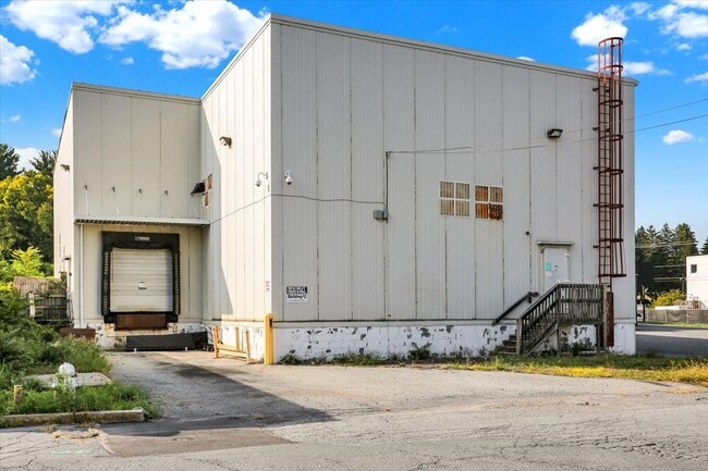


Property Detail
415 Gregg Ave
18-5306-49-55-5120
Berks
Shipyard
Pennsylvania
B and X Area of moderate flood hazard, usually the area between the limits of the 100-year and 500-year floods.
171
2025
0.18 AC
2025
Berks
002600
Philadelphia
4,860 SF
Reading, PA
NEARBY LISTINGS FOR SALE OR LEASE
DEMOGRAPHICS near 415 Gregg Ave
1 mile
3 mile
5 mile
2025 Total Population
18,748
135,256
210,602
2030 Population
19,095
137,746
214,677
Pop Growth 2025-2030
+ 1.85%
+ 1.84%
+ 1.93%
Average Age
37
38
39
2025 Total Households
6,740
49,530
78,743
HH Growth 2025-2030
+ 1.62%
+ 1.89%
+ 1.98%
Median Household Inc
$45,469
$54,895
$64,713
Avg Household Size
2.50
2.60
2.50
2025 Avg HH Vehicles
1.00
1.00
2.00
Median Home Value
$153,470
$174,525
$218,444
Median Year Built
1950
1949
1958
Nearby Places
Map Layers
Map Styles
 Street
 Aerial
Layers
 Traffic
 Biking
Places
Listings with unknown addresses are not visible on the map
- Restaurants
- Banks
- Shops
- Fitness
- Groceries
SALE & LEASE HISTORY
LISTING DATE
SALE/LEASE

Sep 20, 2024
For Sale
Nearby Properties
Address
Land Use
TOTAL SIZE
Lot Size
Zoning
Address
Land Use
TOTAL SIZE
Lot Size
Zoning
732,361 SF
110.76 AC
Address
Land Use
TOTAL SIZE
Lot Size
Zoning
33,761 SF
4.38 AC
Address
Land Use
TOTAL SIZE
Lot Size
Zoning
392,251 SF
78.10 AC
Address
Land Use
TOTAL SIZE
Lot Size
Zoning
342,332 SF
3.30 AC
Address
Land Use
TOTAL SIZE
Lot Size
Zoning
144,696 SF
7.43 AC
Address
Land Use
TOTAL SIZE
Lot Size
Zoning
88,576 SF
1.80 AC
Address
Land Use
TOTAL SIZE
Lot Size
Zoning
209,584 SF
24.33 AC
Address
Land Use
TOTAL SIZE
Lot Size
Zoning
130,410 SF
23.02 AC
Address
Land Use
TOTAL SIZE
Lot Size
Zoning
138,752 SF
21.81 AC
Address
Land Use
TOTAL SIZE
Lot Size
Zoning
104,559 SF
14.14 AC
Address
Land Use
TOTAL SIZE
Lot Size
Zoning
20,731 SF
28.51 AC
Address
Land Use
TOTAL SIZE
Lot Size
Zoning
71,271 SF
1.42 AC
Address
Land Use
TOTAL SIZE
Lot Size
Zoning
174,046 SF
6.92 AC
Address
Land Use
TOTAL SIZE
Lot Size
Zoning
62,907 SF
5.25 AC
Address
Land Use
TOTAL SIZE
Lot Size
Zoning
116,788 SF
13.11 AC
Address
Land Use
TOTAL SIZE
Lot Size
Zoning
163,466 SF
19.19 AC
Address
Land Use
TOTAL SIZE
Lot Size
Zoning
66,610 SF
5.38 AC
Address
Land Use
TOTAL SIZE
Lot Size
Zoning
27,055 SF
1.77 AC
Address
Land Use
TOTAL SIZE
Lot Size
Zoning
104,304 SF
9.77 AC
Address
Land Use
TOTAL SIZE
Lot Size
Zoning
107,379 SF
3.30 AC
Address
Land Use
TOTAL SIZE
Lot Size
Zoning
295,427 SF
9.71 AC
Address
Land Use
TOTAL SIZE
Lot Size
Zoning
24,245 SF
4 AC
Address
Land Use
TOTAL SIZE
Lot Size
Zoning
81,892 SF
2.61 AC
Address
Land Use
TOTAL SIZE
Lot Size
Zoning
30,384 SF
2.95 AC
Address
Land Use
TOTAL SIZE
Lot Size
Zoning
42,496 SF
10.43 AC
Address
Land Use
TOTAL SIZE
Lot Size
Zoning
125,406 SF
14.35 AC
Address
Land Use
TOTAL SIZE
Lot Size
Zoning
204,844 SF
16.33 AC
Address
Land Use
TOTAL SIZE
Lot Size
Zoning
57,750 SF
4.07 AC
Address
Land Use
TOTAL SIZE
Lot Size
Zoning
84,599 SF
28.56 AC
Address
Land Use
TOTAL SIZE
Lot Size
Zoning
37,960 SF
21.97 AC
The World's #1 Commercial Real Estate Marketplace
Connect with us
© 2026 CoStar Group
The information above has been obtained from sources believed reliable. While we do not doubt its accuracy we have not verified it and make no guarantee, warranty or representation about it. It is your responsibility to independently confirm its accuracy and completeness. Any projections, opinions, assumptions, or estimates used are for example only and do not represent the current or future performance of the property. The value of this transaction to you depends on tax and other factors which should be evaluated by your tax, financial, and legal advisors. You and your advisors should conduct a careful, independent investigation of the property to determine to your satisfaction the suitability of the property for your needs.