Property Record
650 S Green Rd, Cleveland, OH 44121
This Property Is For Sale
NEARBY LISTINGS FOR SALE OR LEASE
Property Detail
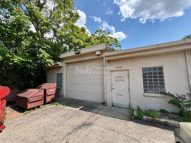
650 S Green Rd
Cleveland-Elyria, OH
S Of Green
701-11-048
60 SP 210FT S OF GREENVALE DR
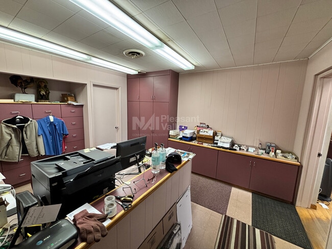
Autorepair
Cuyahoga
X
Ohio
39035C0092E
60
2024
0.48 AC
2024
East
185101
Cleveland
3,950 SF
DEMOGRAPHICS near 650 S Green Rd
1 Mile
3 Mile
5 Mile
2024 Total Population
12,110
108,749
285,356
2029 Population
11,800
107,039
281,634
Pop Growth 2024-2029
(2.56%)
(1.57%)
(1.30%)
Average Age
41
42
41
2024 Total Households
5,042
48,306
126,306
HH Growth 2024-2029
(2.82%)
(1.63%)
(1.34%)
Median Household Inc
$59,614
$47,808
$49,403
Avg Household Size
2.30
2.20
2.10
2024 Avg HH Vehicles
2.00
1.00
1.00
Median Home Value
$122,035
$139,808
$158,132
Median Year Built
1953
1953
1953
Nearby Places
- Restaurants
- Banks
- Shops
- Fitness
- Groceries
PUBLIC TRANSPORTATION
AIRPORT
Cleveland-Hopkins International
DRIVE
WALK
Distance
Cleveland-Hopkins International
42 min
25.3 mi
Freight Ports
Port of Toledo
DRIVE
WALK
Distance
Port of Toledo
156 min
125.7 mi
Nearby Properties
Address
Land Use
TOTAL SIZE
Lot Size
Zoning
Address
Land Use
TOTAL SIZE
Lot Size
Zoning
379,326 SF
43.45 AC
CRG
Address
Land Use
TOTAL SIZE
Lot Size
Zoning
44,577 SF
39.90 AC
SI
Address
Land Use
TOTAL SIZE
Lot Size
Zoning
257,048 SF
17.93 AC
S1
Address
Land Use
TOTAL SIZE
Lot Size
Zoning
112,657 SF
19.88 AC
U3
Address
Land Use
TOTAL SIZE
Lot Size
Zoning
252,759 SF
27.66 AC
R-1
Address
Land Use
TOTAL SIZE
Lot Size
Zoning
92,442 SF
159.84 AC
I-1
Address
Land Use
TOTAL SIZE
Lot Size
Zoning
166,392 SF
36.46 AC
RMF-2
Address
Land Use
TOTAL SIZE
Lot Size
Zoning
91,540 SF
14.35 AC
CRG
Address
Land Use
TOTAL SIZE
Lot Size
Zoning
2.53 AC
U6
Address
Land Use
TOTAL SIZE
Lot Size
Zoning
222,426 SF
3.60 AC
U1
Address
Land Use
TOTAL SIZE
Lot Size
Zoning
131,846 SF
5.94 AC
U-9
Address
Land Use
TOTAL SIZE
Lot Size
Zoning
628,514 SF
25.95 AC
B-2
Address
Land Use
TOTAL SIZE
Lot Size
Zoning
100,469 SF
25.96 AC
AA
Address
Land Use
TOTAL SIZE
Lot Size
Zoning
255,964 SF
39.41 AC
R-75
Address
Land Use
TOTAL SIZE
Lot Size
Zoning
275,040 SF
9.07 AC
U3
Address
Land Use
TOTAL SIZE
Lot Size
Zoning
628,514 SF
0.67 AC
B-2
Address
Land Use
TOTAL SIZE
Lot Size
Zoning
27,466 SF
13.39 AC
U6
Address
Land Use
TOTAL SIZE
Lot Size
Zoning
157,761 SF
14.27 AC
R-50
Address
Land Use
TOTAL SIZE
Lot Size
Zoning
89,347 SF
1.10 AC
CRG
Address
Land Use
TOTAL SIZE
Lot Size
Zoning
61,352 SF
10.79 AC
M-I
Address
Land Use
TOTAL SIZE
Lot Size
Zoning
129,593 SF
72.95 AC
P
Address
Land Use
TOTAL SIZE
Lot Size
Zoning
111,800 SF
8 AC
1F-4
Address
Land Use
TOTAL SIZE
Lot Size
Zoning
65,444 SF
7.10 AC
C-C
Address
Land Use
TOTAL SIZE
Lot Size
Zoning
249,374 SF
18.67 AC
1F-4
Address
Land Use
TOTAL SIZE
Lot Size
Zoning
162,679 SF
26.07 AC
1F-2
Address
Land Use
TOTAL SIZE
Lot Size
Zoning
97,120 SF
16.61 AC
C-C
Address
Land Use
TOTAL SIZE
Lot Size
Zoning
339,686 SF
5.65 AC
2F
Address
Land Use
TOTAL SIZE
Lot Size
Zoning
183,165 SF
18.93 AC
C-2
Address
Land Use
TOTAL SIZE
Lot Size
Zoning
80,547 SF
4.52 AC
CRG
Address
Land Use
TOTAL SIZE
Lot Size
Zoning
235,391 SF
4.90 AC
S1
The World's #1 Commercial Real Estate Marketplace
Connect with us
© 2025 CoStar Group
The information above has been obtained from sources believed reliable. While we do not doubt its accuracy we have not verified it and make no guarantee, warranty or representation about it. It is your responsibility to independently confirm its accuracy and completeness. Any projections, opinions, assumptions, or estimates used are for example only and do not represent the current or future performance of the property. The value of this transaction to you depends on tax and other factors which should be evaluated by your tax, financial, and legal advisors. You and your advisors should conduct a careful, independent investigation of the property to determine to your satisfaction the suitability of the property for your needs.