Property Record
42 Leonard St, Norton, MA 02766
NEARBY LISTINGS FOR SALE OR LEASE
Property Detail
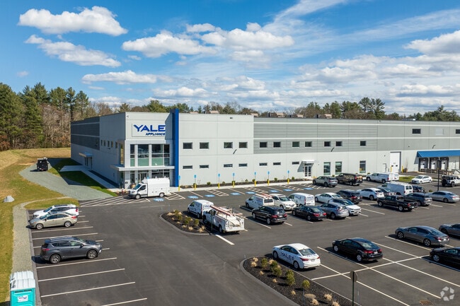
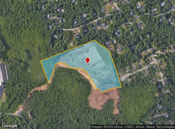
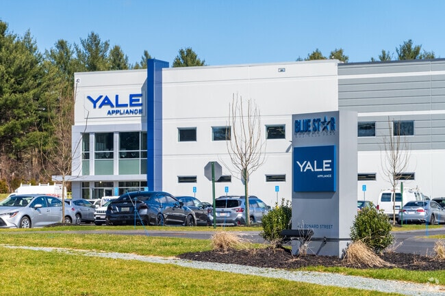
42 Leonard St
Warehouse
Bristol
X
Massachusetts
25005C0132F
18.47 AC
2025
Attleboro/New Bedford
2025
Boston
611102
Providence-Warwick, RI-MA
225,600 SF
NORT M:11 P:25-01
DEMOGRAPHICS near 42 Leonard St
1 Mile
3 Mile
5 Mile
2024 Total Population
2,568
17,462
61,985
2029 Population
2,554
17,393
61,656
Pop Growth 2024-2029
(0.55%)
(0.40%)
(0.53%)
Average Age
42
41
42
2024 Total Households
992
6,042
23,286
HH Growth 2024-2029
(0.60%)
(0.25%)
(0.52%)
Median Household Inc
$107,954
$117,936
$108,990
Avg Household Size
2.60
2.70
2.50
2024 Avg HH Vehicles
2.00
2.00
2.00
Median Home Value
$498,675
$485,188
$464,782
Median Year Built
1987
1983
1980
Nearby Places
Map Layers
Map Styles
 Street
 Aerial
- Restaurants
- Banks
- Shops
- Fitness
- Groceries
PUBLIC TRANSPORTATION
COMMUTER RAIL
Mansfield (Foxboro Line (Special Events Only) - Massachusetts Bay Transportation Authority Commuter Rail (Purple Line), Providence/Stoughton Line - Massachusetts Bay Transportation Authority Commuter Rail (Purple Line))
DRIVE
WALK
Distance
Mansfield (Foxboro Line (Special Events Only) - Massachusetts Bay Transportation Authority Commuter Rail (Purple Line), Providence/Stoughton Line - Massachusetts Bay Transportation Authority Commuter Rail (Purple Line))
16 min
8.2 mi
Attleboro (Providence/Stoughton Line - Massachusetts Bay Transportation Authority Commuter Rail (Purple Line))
DRIVE
WALK
Distance
Attleboro (Providence/Stoughton Line - Massachusetts Bay Transportation Authority Commuter Rail (Purple Line))
18 min
9.6 mi
AIRPORT
General Edward Lawrence Logan International
DRIVE
WALK
Distance
General Edward Lawrence Logan International
55 min
34.5 mi
Rhode Island Tf Green International
DRIVE
WALK
Distance
Rhode Island Tf Green International
53 min
34.6 mi
Freight Ports
Port of Boston
DRIVE
WALK
Distance
Port of Boston
52 min
32.3 mi
Nearby Properties
Address
Land Use
TOTAL SIZE
Lot Size
Zoning
Address
Land Use
TOTAL SIZE
Lot Size
Zoning
20.33 AC
Address
Land Use
TOTAL SIZE
Lot Size
Zoning
559,641 SF
73.61 AC
Address
Land Use
TOTAL SIZE
Lot Size
Zoning
3,838 SF
1.11 AC
R80
Address
Land Use
TOTAL SIZE
Lot Size
Zoning
223,480 SF
37.59 AC
Address
Land Use
TOTAL SIZE
Lot Size
Zoning
315,896 SF
24.53 AC
INDUST
Address
Land Use
TOTAL SIZE
Lot Size
Zoning
225,600 SF
18.47 AC
R80
Address
Land Use
TOTAL SIZE
Lot Size
Zoning
212,672 SF
34.40 AC
Address
Land Use
TOTAL SIZE
Lot Size
Zoning
201,634 SF
12.01 AC
Address
Land Use
TOTAL SIZE
Lot Size
Zoning
361,737 SF
20 AC
INDUST
Address
Land Use
TOTAL SIZE
Lot Size
Zoning
25.26 AC
INDUST
Address
Land Use
TOTAL SIZE
Lot Size
Zoning
145,360 SF
11.80 AC
Address
Land Use
TOTAL SIZE
Lot Size
Zoning
Address
Land Use
TOTAL SIZE
Lot Size
Zoning
Address
Land Use
TOTAL SIZE
Lot Size
Zoning
123,740 SF
10.67 AC
R80
Address
Land Use
TOTAL SIZE
Lot Size
Zoning
213,128 SF
12 AC
INDUST
Address
Land Use
TOTAL SIZE
Lot Size
Zoning
105,664 SF
13.16 AC
Address
Land Use
TOTAL SIZE
Lot Size
Zoning
26.70 AC
Address
Land Use
TOTAL SIZE
Lot Size
Zoning
153,057 SF
13.96 AC
INDUST
Address
Land Use
TOTAL SIZE
Lot Size
Zoning
198,720 SF
15.10 AC
INDUST
Address
Land Use
TOTAL SIZE
Lot Size
Zoning
32.93 AC
BIZDIS
Address
Land Use
TOTAL SIZE
Lot Size
Zoning
82,946 SF
25.50 AC
Address
Land Use
TOTAL SIZE
Lot Size
Zoning
129,261 SF
12.87 AC
Address
Land Use
TOTAL SIZE
Lot Size
Zoning
103,765 SF
19.83 AC
Address
Land Use
TOTAL SIZE
Lot Size
Zoning
117,076 SF
5.16 AC
INDUST
Address
Land Use
TOTAL SIZE
Lot Size
Zoning
62,555 SF
5.09 AC
OFFDIS
Address
Land Use
TOTAL SIZE
Lot Size
Zoning
143,860 SF
12.71 AC
INDUST
Address
Land Use
TOTAL SIZE
Lot Size
Zoning
112,500 SF
13.83 AC
Address
Land Use
TOTAL SIZE
Lot Size
Zoning
80,405 SF
6.09 AC
INDUST
Address
Land Use
TOTAL SIZE
Lot Size
Zoning
49,200 SF
11.57 AC
Address
Land Use
TOTAL SIZE
Lot Size
Zoning
15.28 AC
The World's #1 Commercial Real Estate Marketplace
Connect with us
© 2026 CoStar Group
The information above has been obtained from sources believed reliable. While we do not doubt its accuracy we have not verified it and make no guarantee, warranty or representation about it. It is your responsibility to independently confirm its accuracy and completeness. Any projections, opinions, assumptions, or estimates used are for example only and do not represent the current or future performance of the property. The value of this transaction to you depends on tax and other factors which should be evaluated by your tax, financial, and legal advisors. You and your advisors should conduct a careful, independent investigation of the property to determine to your satisfaction the suitability of the property for your needs.