Property Record
420 Munson Ave, Traverse City, MI 49686
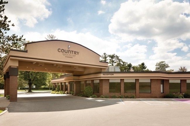

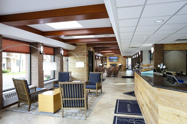
Property Detail
420 Munson Ave
51-180-001-00
UNIT 1 OF M-8-2 CONDOMINIUM GTC CONDO SUB PLAN NO 425 2018C-00032 MASTER DEED FILED MAY 21, 2018. 2018C-00061 1ST AMENDMENT T
Commercialnec
GRAND TRAVERSE
B and X Area of moderate flood hazard, usually the area between the limits of the 100-year and 500-year floods.
Michigan
2024
0.85 AC
2025
Michigan Northwest Area
551000
Other Market Areas
46,824 SF
Traverse City, MI
NEARBY LISTINGS FOR SALE OR LEASE
DEMOGRAPHICS near 420 Munson Ave
1 mile
3 mile
5 mile
2025 Total Population
4,536
23,843
43,441
2030 Population
4,553
23,763
43,191
Pop Growth 2025-2030
+ 0.37%
(0.34%)
(0.58%)
Average Age
42
44
44
2025 Total Households
1,969
11,262
19,736
HH Growth 2025-2030
+ 0.36%
(0.36%)
(0.57%)
Median Household Inc
$83,035
$69,597
$78,443
Avg Household Size
2.10
2.00
2.10
2025 Avg HH Vehicles
2.00
2.00
2.00
Median Home Value
$365,492
$352,930
$361,409
Median Year Built
1968
1976
1982
Nearby Places
Map Layers
Map Styles
 Street
 Aerial
Layers
 Traffic
 Biking
Places
Listings with unknown addresses are not visible on the map
- Restaurants
- Banks
- Shops
- Fitness
- Groceries
PUBLIC TRANSPORTATION
AIRPORT
Cherry Capital
Drive
Walk
Distance
Cherry Capital
7 min
1.8 mi
Freight Ports
Port Milwaukee
Drive
Walk
Distance
Port Milwaukee
461 min
402.7 mi
SALE & LEASE HISTORY
LISTING DATE
SALE/LEASE

Feb 07, 2020
For Sale
Apr 18, 2019
For Sale
Nearby Properties
Address
Land Use
TOTAL SIZE
Lot Size
Zoning
Address
Land Use
TOTAL SIZE
Lot Size
Zoning
100,935 SF
35.95 AC
Address
Land Use
TOTAL SIZE
Lot Size
Zoning
81,900 SF
870.88 AC
Address
Land Use
TOTAL SIZE
Lot Size
Zoning
103,000 SF
4.77 AC
Address
Land Use
TOTAL SIZE
Lot Size
Zoning
123,544 SF
3.93 AC
Address
Land Use
TOTAL SIZE
Lot Size
Zoning
53,806 SF
77.29 AC
Address
Land Use
TOTAL SIZE
Lot Size
Zoning
41,084 SF
22.79 AC
Address
Land Use
TOTAL SIZE
Lot Size
Zoning
75,085 SF
0.84 AC
Address
Land Use
TOTAL SIZE
Lot Size
Zoning
72,997 SF
0.65 AC
Address
Land Use
TOTAL SIZE
Lot Size
Zoning
78,393 SF
7.83 AC
Address
Land Use
TOTAL SIZE
Lot Size
Zoning
131,040 SF
22.23 AC
Address
Land Use
TOTAL SIZE
Lot Size
Zoning
77,000 SF
1.71 AC
Address
Land Use
TOTAL SIZE
Lot Size
Zoning
6,354 SF
97.88 AC
Address
Land Use
TOTAL SIZE
Lot Size
Zoning
40,790 SF
2.31 AC
Address
Land Use
TOTAL SIZE
Lot Size
Zoning
33,184 SF
0.76 AC
Address
Land Use
TOTAL SIZE
Lot Size
Zoning
139,710 SF
8.04 AC
Address
Land Use
TOTAL SIZE
Lot Size
Zoning
71,400 SF
3.69 AC
Address
Land Use
TOTAL SIZE
Lot Size
Zoning
155,000 SF
12.63 AC
Address
Land Use
TOTAL SIZE
Lot Size
Zoning
89,143 SF
2.73 AC
Address
Land Use
TOTAL SIZE
Lot Size
Zoning
8,820 SF
15.24 AC
Address
Land Use
TOTAL SIZE
Lot Size
Zoning
38,232 SF
0.65 AC
Address
Land Use
TOTAL SIZE
Lot Size
Zoning
28,620 SF
3.86 AC
Address
Land Use
TOTAL SIZE
Lot Size
Zoning
54,254 SF
4.83 AC
Address
Land Use
TOTAL SIZE
Lot Size
Zoning
720 SF
3.80 AC
Address
Land Use
TOTAL SIZE
Lot Size
Zoning
11.25 AC
Address
Land Use
TOTAL SIZE
Lot Size
Zoning
186,482 SF
1.43 AC
Address
Land Use
TOTAL SIZE
Lot Size
Zoning
65,392 SF
1.54 AC
Address
Land Use
TOTAL SIZE
Lot Size
Zoning
17,892 SF
18.28 AC
Address
Land Use
TOTAL SIZE
Lot Size
Zoning
65,775 SF
1.99 AC
Address
Land Use
TOTAL SIZE
Lot Size
Zoning
4,377 SF
3.90 AC
Address
Land Use
TOTAL SIZE
Lot Size
Zoning
74,411 SF
28.31 AC
The World's #1 Commercial Real Estate Marketplace
Connect with us
© 2026 CoStar Group
The information above has been obtained from sources believed reliable. While we do not doubt its accuracy we have not verified it and make no guarantee, warranty or representation about it. It is your responsibility to independently confirm its accuracy and completeness. Any projections, opinions, assumptions, or estimates used are for example only and do not represent the current or future performance of the property. The value of this transaction to you depends on tax and other factors which should be evaluated by your tax, financial, and legal advisors. You and your advisors should conduct a careful, independent investigation of the property to determine to your satisfaction the suitability of the property for your needs.