Property Record
4200 S East St, Indianapolis, IN 46227

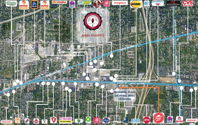

NEARBY LISTINGS FOR SALE OR LEASE
Property Detail
4200 S East St
49-11-36-104-055.000-570
5.00 S263.4 SW131.6 SW48.1 W1437.47 N261.98 E50.95 SERLY30.26 E2.92 SERLY174.19 SE96.76 N404.81 E32.38 N312.80 E31.50 N135 E594.23 N4.11 E577.44 TO BEG 26.805 AC.
Regionalshoppingcenterormallwithanchorstore
Marion
X
Indiana
18097C0234F
26.81 AC
2023
Edgewood/South County
2024
Indianapolis
380600
Indianapolis-Carmel-Greenwood, IN
220,708 SF
DEMOGRAPHICS near 4200 S East St
1 Mile
3 Mile
5 Mile
2024 Total Population
9,610
67,643
209,859
2029 Population
9,447
67,072
208,342
Pop Growth 2024-2029
(1.70%)
(0.84%)
(0.72%)
Average Age
35
36
37
2024 Total Households
3,609
26,219
84,969
HH Growth 2024-2029
(1.91%)
(0.92%)
(0.70%)
Median Household Inc
$57,256
$54,741
$58,939
Avg Household Size
2.30
2.40
2.40
2024 Avg HH Vehicles
2.00
2.00
2.00
Median Home Value
$151,609
$165,167
$171,487
Median Year Built
1963
1961
1967
Nearby Places
Map Layers
Map Styles
 Street
 Aerial
- Restaurants
- Banks
- Shops
- Fitness
- Groceries
PUBLIC TRANSPORTATION
COMMUTER RAIL
Indianapolis (Cardinal - Amtrak)
DRIVE
WALK
Distance
Indianapolis (Cardinal - Amtrak)
8 min
4.5 mi
AIRPORT
Indianapolis International
DRIVE
WALK
Distance
Indianapolis International
26 min
14.6 mi
Freight Ports
Port of Toledo
DRIVE
WALK
Distance
Port of Toledo
277 min
230.1 mi
SALE & LEASE HISTORY
LISTING DATE
SALE/LEASE

Sep 24, 2016
For Lease
Nearby Properties
Address
Land Use
TOTAL SIZE
Lot Size
Zoning
Address
Land Use
TOTAL SIZE
Lot Size
Zoning
19,927 SF
28.82 AC
ZO01
Address
Land Use
TOTAL SIZE
Lot Size
Zoning
405,888 SF
19.56 AC
ZO01
Address
Land Use
TOTAL SIZE
Lot Size
Zoning
3,782 SF
44.43 AC
ZO01
Address
Land Use
TOTAL SIZE
Lot Size
Zoning
80,348 SF
2.95 AC
ZO01
Address
Land Use
TOTAL SIZE
Lot Size
Zoning
1,812 SF
11.08 AC
ZO01
Address
Land Use
TOTAL SIZE
Lot Size
Zoning
3,818 SF
15.24 AC
Address
Land Use
TOTAL SIZE
Lot Size
Zoning
51,196 SF
50.61 AC
ZO01
Address
Land Use
TOTAL SIZE
Lot Size
Zoning
4,476 SF
12.18 AC
Address
Land Use
TOTAL SIZE
Lot Size
Zoning
3,003 SF
3.52 AC
ZO01
Address
Land Use
TOTAL SIZE
Lot Size
Zoning
5,665 SF
25.25 AC
ZO01
Address
Land Use
TOTAL SIZE
Lot Size
Zoning
39,618 SF
8.17 AC
ZO01
Address
Land Use
TOTAL SIZE
Lot Size
Zoning
405 SF
23.81 AC
ZO01
Address
Land Use
TOTAL SIZE
Lot Size
Zoning
1,932 SF
19.63 AC
ZO01
Address
Land Use
TOTAL SIZE
Lot Size
Zoning
2,928 SF
17.76 AC
Address
Land Use
TOTAL SIZE
Lot Size
Zoning
4,212 SF
16 AC
Address
Land Use
TOTAL SIZE
Lot Size
Zoning
4,872 SF
12.37 AC
Address
Land Use
TOTAL SIZE
Lot Size
Zoning
1,040 SF
15.62 AC
ZO01
Address
Land Use
TOTAL SIZE
Lot Size
Zoning
9,160 SF
2.54 AC
ZO01
Address
Land Use
TOTAL SIZE
Lot Size
Zoning
101,122 SF
16.44 AC
Address
Land Use
TOTAL SIZE
Lot Size
Zoning
1,372 SF
25.27 AC
Address
Land Use
TOTAL SIZE
Lot Size
Zoning
38,598 SF
2.83 AC
ZO01
Address
Land Use
TOTAL SIZE
Lot Size
Zoning
112,178 SF
23.51 AC
ZO01
Address
Land Use
TOTAL SIZE
Lot Size
Zoning
5,075 SF
8 AC
ZO01
Address
Land Use
TOTAL SIZE
Lot Size
Zoning
3,208 SF
5.22 AC
ZO01
Address
Land Use
TOTAL SIZE
Lot Size
Zoning
199,600 SF
12.31 AC
Address
Land Use
TOTAL SIZE
Lot Size
Zoning
24,808 SF
6.90 AC
ZO01
Address
Land Use
TOTAL SIZE
Lot Size
Zoning
27,703 SF
22 AC
Address
Land Use
TOTAL SIZE
Lot Size
Zoning
72,509 SF
11.07 AC
ZO01
Address
Land Use
TOTAL SIZE
Lot Size
Zoning
45,303 SF
15.51 AC
ZO01
The World's #1 Commercial Real Estate Marketplace
Connect with us
© 2026 CoStar Group
The information above has been obtained from sources believed reliable. While we do not doubt its accuracy we have not verified it and make no guarantee, warranty or representation about it. It is your responsibility to independently confirm its accuracy and completeness. Any projections, opinions, assumptions, or estimates used are for example only and do not represent the current or future performance of the property. The value of this transaction to you depends on tax and other factors which should be evaluated by your tax, financial, and legal advisors. You and your advisors should conduct a careful, independent investigation of the property to determine to your satisfaction the suitability of the property for your needs.